ORH_wxman
-
Posts
93,095 -
Joined
-
Last visited
Content Type
Profiles
Blogs
Forums
American Weather
Media Demo
Store
Gallery
Everything posted by ORH_wxman
-
December 2021 Obs/Disco...Dreaming of a White-Weenie Xmas
ORH_wxman replied to 40/70 Benchmark's topic in New England
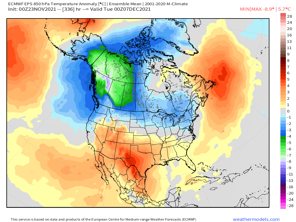
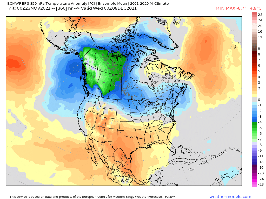
Pretty classic “good La Niña” look on that run where the N tier gets cold and active storm track. You can see the gradient there on the 850 temp anomalies (and it’s easy to see at H5 too). That’s definitely what we are hoping for. It helps that the Atlantic isn’t horrific...almost kind of neutral look there. PV also displaced a little south toward our side of the pole.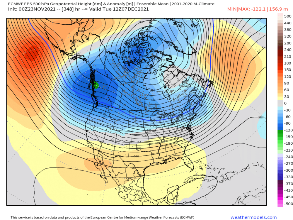
-
I’d be surprised if we don’t at least get the “first flakes” monkey off our back for many of the areas who haven’t seen them yet. Prob a lot of popcorn snow showers around with that upper level cold pool even if we don’t get a real storm.
-
December 2021 Obs/Disco...Dreaming of a White-Weenie Xmas
ORH_wxman replied to 40/70 Benchmark's topic in New England
EPS looked really solid last night. We’ll take this for sure....

-
May have to watch for a follow-up clipper if that Sunday/Monday system gets crunched offshore. The cold definitely has been getting prolonged on guidance. Seems like we may only torch for a brief time now...hopefully that holds.
-
The anomalies up there were incredible that winter. That had to be like a minus 3-sigma event.
-
This is the same "system" from the post I made several days ago....interesting that it has reappeared recently (GGEM has it too but just a day earlier).
-
December 2021 Obs/Disco...Dreaming of a White-Weenie Xmas
ORH_wxman replied to 40/70 Benchmark's topic in New England
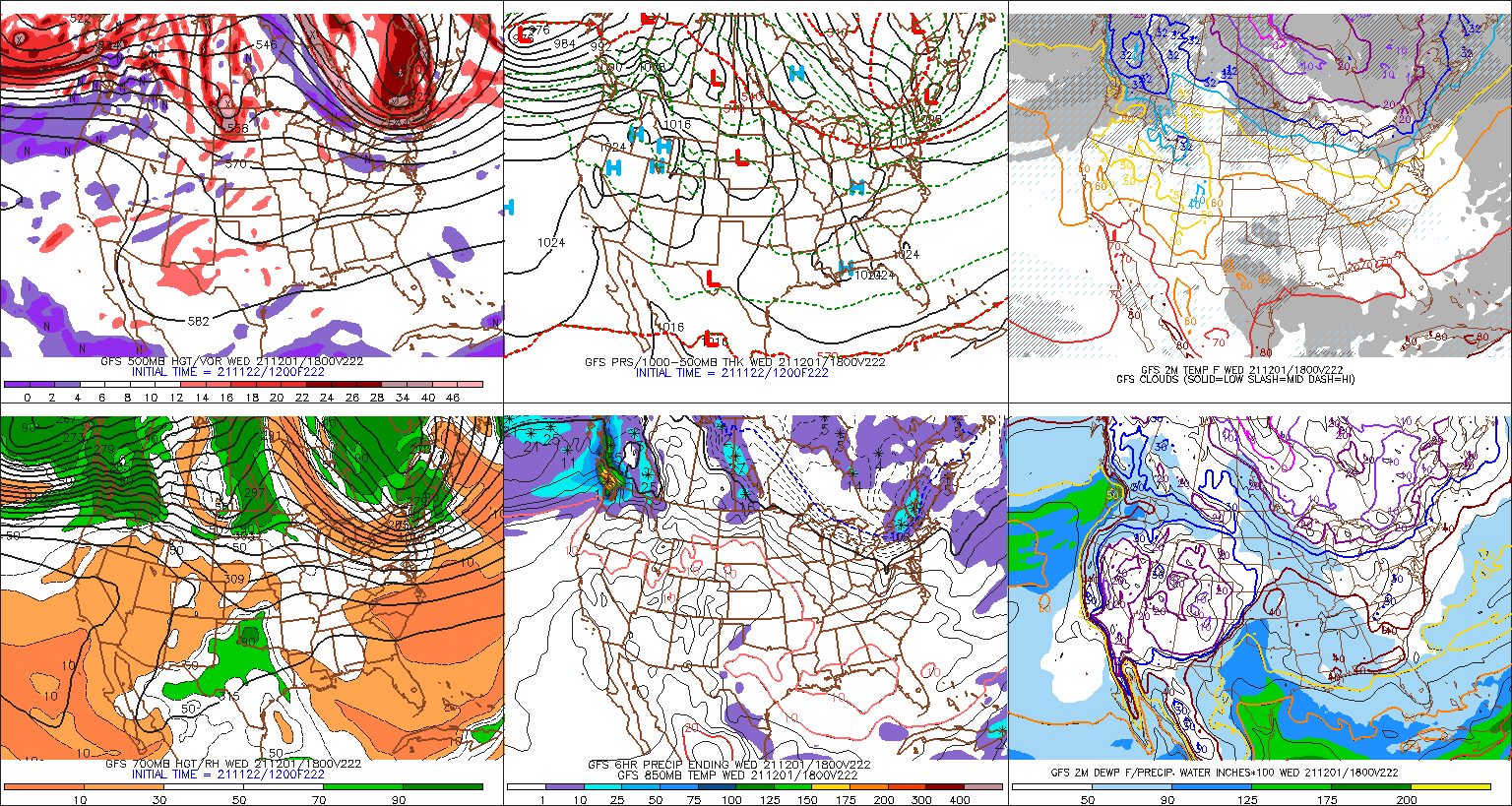
Maybe...there's a lot of uncertainty in our area actually for the first several days of December....several pieces of guidance are trying to drill a localized cold shot via a PV lobe into NE while the upper plains torch away....that could shorten the amount of time we have any real true torchy weather. Here's an example from the 12z GFS below....yes, its clown range so obviousl this can/will change, but we don;t know which direction it will change. Maybe we end up torchier, but we could also end up colder/snowier like the 12z GGEM shows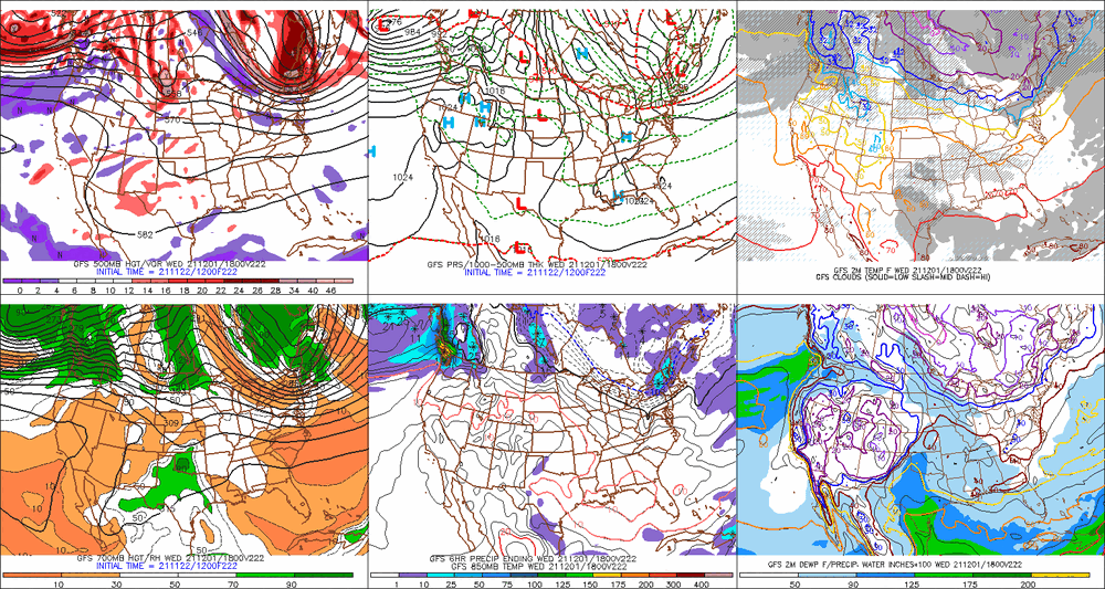
-
December 2021 Obs/Disco...Dreaming of a White-Weenie Xmas
ORH_wxman replied to 40/70 Benchmark's topic in New England
Most of those early Dec 1995 days in BOS were below average. I think we only cracked 40F maybe twice in ORH during that stretch.....but the real snow started on 12/9 when we got about 5 inches and then some ZR (BOS changed to rain in that one). We did have some leftover snow from 11/29/95 still in spots though before 12/9. -
Yeah the upslope spots will see some action on Friday/Saturday. Pretty good ULL spinning there nin N Maine and S Quebec for a couple days wrapping around some cyclonic flow and moisture.
-
December 2021 Obs/Disco...Dreaming of a White-Weenie Xmas
ORH_wxman replied to 40/70 Benchmark's topic in New England
What is good is that all the ensemble guidance (EPS/GEFS/GEPS) all show the Aleutian ridge rebuilding into the Bering Strait....so this isn't just one model ensemble showing it. We just need to keep an eye on the timing....if it keeps getting pushed back, then that would be trouble. If not, then we're probably going to have a nice period IMHO in mid-December. -
We actually had the ice storm that week....then a brief torch after the ice storm before things went crazy for a few days 12/19-12/21
-
December 2021 Obs/Disco...Dreaming of a White-Weenie Xmas
ORH_wxman replied to 40/70 Benchmark's topic in New England
Yeah model gudiance has punted very early December for a few days now....we're gonna get a full torch for a few days there. But they are pretty adamant about rebuilding the Aleutian ridging into the WPO region by about Dec 7-9 or so. That should set the stage for some cold air bleeding down into northern CONUS and get some winter wx threats. -
2pm Saturday, 11/20 @ Funky Murphy's ORH
ORH_wxman replied to 40/70 Benchmark's topic in New England
Looked like great times. Really bummed I had to bail on this one at the last second but couldn’t attend in good conscience being under the weather. I’ll def try and make the next one. -
Yes. It’s looking like we could go full-torch for a few days in early December as the pattern shuffles. But we’ll see. If the NAO hangs a little tougher then the mild air would be blunted. Longer range guidance has been fairly volatile so confidence is low. That Aleutian ridge building up has been pretty consistent though. It’s just a long ways out so the timing isn’t going to be exact.
-
2pm Saturday, 11/20 @ Funky Murphy's ORH
ORH_wxman replied to 40/70 Benchmark's topic in New England
Everyone woke up this morning in my house under the weather. Normally I’d still come but I can’t in good faith...esp with the holiday just a few days away. Real bummer. Was looking forward to this one too. I’ll def try make next one. -
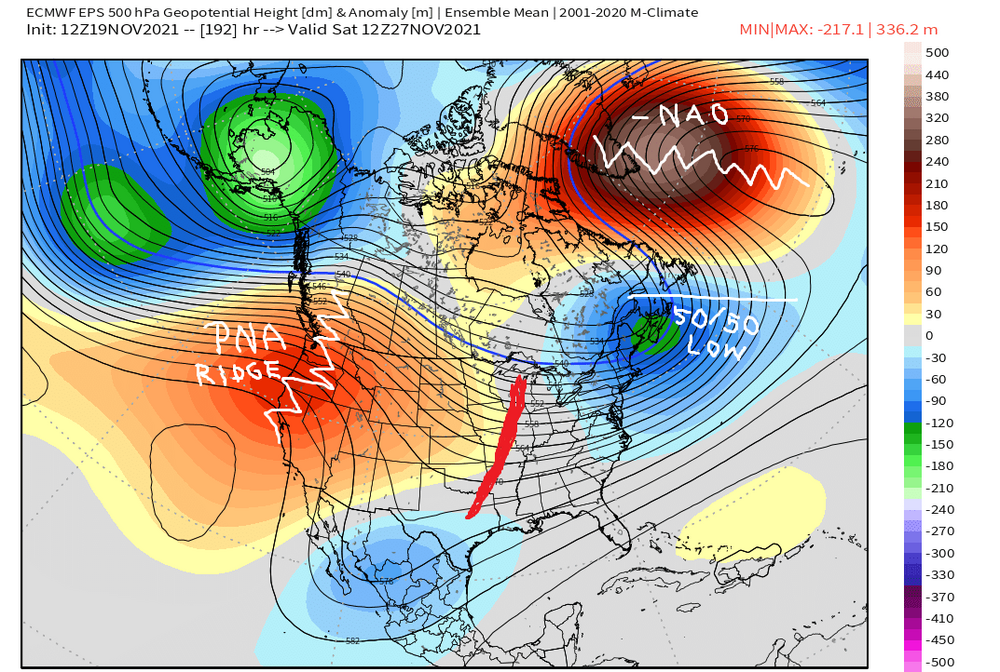
Here's the EPS....you can see how the longwave pattern is pretty decent synoptically for a threat....you obviously need the details to work out, but the larger pieces are there..... You have your -NAO forcing the PV lobe under it into 50/50 low position while you have the main trough axis still back in the center of the CONUS and a nice PNA ridge to help amplify anything diving into that trough. Still a long shot but it's at least a compelling setup.
-
The pattern is definitely trying to become favorable for a threat somewhere in that Nov 28-30 time frame. Nice little PV-lobe is trying to get forced underneath the -NAO after T-day which sets the stage for a shortwave to run into that cold air supply...aided by a little PNA ridge popping out west at the same time. Tip has been mentioning this symbiotic relationship between the NAO tanking and the PNA rising....and maybe this is finally the models "seeing" the correction event. We're still a long ways out, but it is a period to keep an eye on.
-
2pm Saturday, 11/20 @ Funky Murphy's ORH
ORH_wxman replied to 40/70 Benchmark's topic in New England
It' about 50/50 here I'd say. Back around late Aug and Sept, it had crept up to like 70-75% masked, but has since fallen back down to about half. Still not down to the low of maybe 20% we saw back in June (mostly pre-Delta). -
2pm Saturday, 11/20 @ Funky Murphy's ORH
ORH_wxman replied to 40/70 Benchmark's topic in New England
Once you are inside with food or a drink, they won't care. Everyone takes them off. Something like 94% of MA adults are vaxxed anyway...it's mostly a performative mandate. -
Little piggy never really gets established....transient....which is a good thing.
-
2019 went snowless in both Oct/Nov here. I’m using “snowless” as a synonym for no measurable since Kevin said flakes don’t count. We had it happen in 2017 too.
-
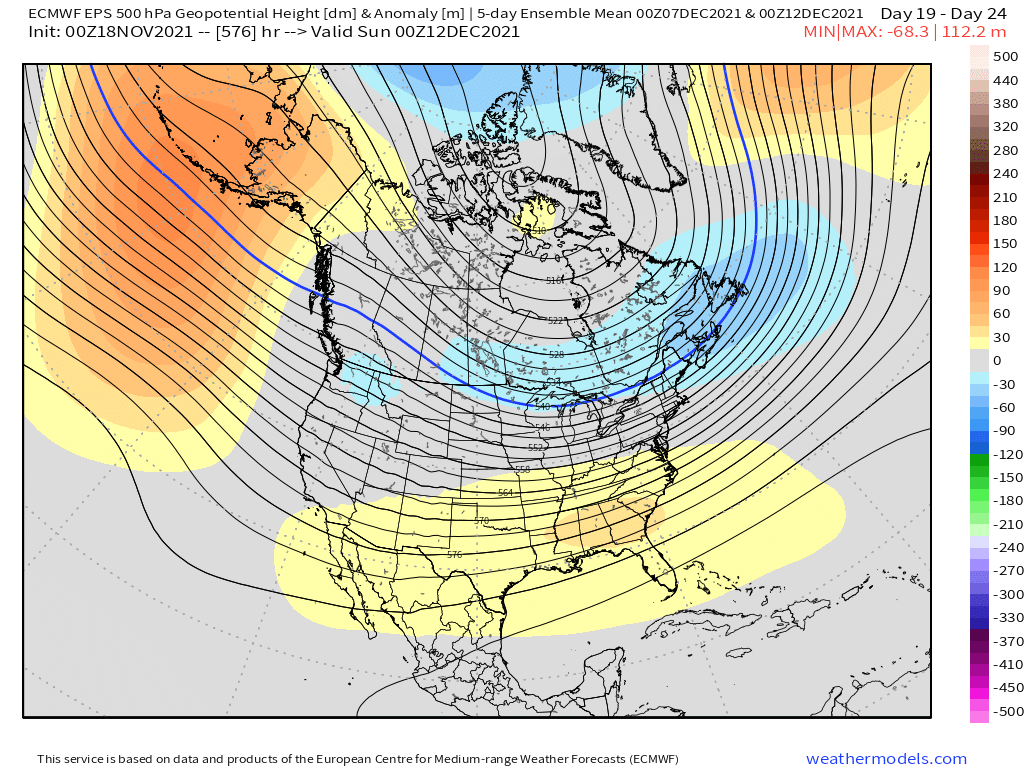
Pretty nice gradient pattern developing 2nd week of Dec

-
December looks pretty nice here on the weeklies....lets hope they have a clue. Lots of cold up north and we're mostly in on it in New England.
-
Yeah that looks tough....hopefully they get blitzed after like 12/5 as more western troughing takes hold. Sometimes it only takes one monster system out there to fix a couple bad weeks.
-
Weeklies also think the AK vortex is transient....quick Aleutian ridge spikes and we are into a classic Nina gradient pattern by 2nd week of December according to them.