ORH_wxman
-
Posts
93,095 -
Joined
-
Last visited
Content Type
Profiles
Blogs
Forums
American Weather
Media Demo
Store
Gallery
Everything posted by ORH_wxman
-
December 2021 Obs/Disco...Dreaming of a White-Weenie Xmas
ORH_wxman replied to 40/70 Benchmark's topic in New England
Agreed.
-
Anafront for sure...IVTs happen every winter pretty much whereas anafront is prob more like 1 every couple or 3 years.
-
December 2021 Obs/Disco...Dreaming of a White-Weenie Xmas
ORH_wxman replied to 40/70 Benchmark's topic in New England
You would think the fast flow would increase smaller events and decrease larger events, but that has not been the case. -
December 2021 Obs/Disco...Dreaming of a White-Weenie Xmas
ORH_wxman replied to 40/70 Benchmark's topic in New England
There's def a chance it comes back....it's really fast flow and models will struggle with it. There's actually quite a bit of spread on the ensembles over the Saturday deal. The trend last night was definitely to shear it out more, but it could easily reverse on the next run. -
December 2021 Obs/Disco...Dreaming of a White-Weenie Xmas
ORH_wxman replied to 40/70 Benchmark's topic in New England
Yeah, we can definitely say for sure that all threats have been identified already prior to 12/10 and we know the outcome of them. -
December 2021 Obs/Disco...Dreaming of a White-Weenie Xmas
ORH_wxman replied to 40/70 Benchmark's topic in New England
Just one season....like 2011-2012....some of these millennials need to experience a 4-5 year stretch like we did in the late 1980s/early 1990s. That'll bring appreciation back for 2-4" snow events. -
December 2021 Obs/Disco...Dreaming of a White-Weenie Xmas
ORH_wxman replied to 40/70 Benchmark's topic in New England
Correct. The warmth has been heavily skewed toward the minimum temps as well which we would expect....also doesn't affect snowfall that much because we aren't radiating during snowstorms. We are using the true profile of the atmosphere and not just the lowest couple hundred feet. -
December 2021 Obs/Disco...Dreaming of a White-Weenie Xmas
ORH_wxman replied to 40/70 Benchmark's topic in New England
You realize we have 10 days until 12/10, right? -
December 2021 Obs/Disco...Dreaming of a White-Weenie Xmas
ORH_wxman replied to 40/70 Benchmark's topic in New England
Not a bad guess....here is 1970-1989 and 2001-2020 for ORH snowfall through 12/10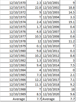
-
December 2021 Obs/Disco...Dreaming of a White-Weenie Xmas
ORH_wxman replied to 40/70 Benchmark's topic in New England
Great storms early that month, but the second half of that month was dogshit. Nice cutter right before Xmas too to wipe out any leftover snow. -
December 2021 Obs/Disco...Dreaming of a White-Weenie Xmas
ORH_wxman replied to 40/70 Benchmark's topic in New England
I'm also not totally convinced how much CC plays a role on these numbers versus just natural variability...you can clearly see there is decade-by-decade noise there. The increase in frequency in 12"+ events is *solely* driven by the 2010s increase. If you look at it from the 1950s-2000s, it is flat. My guess is CC contributes a little bit to the absolute monsters due to increased water vapor, but I think we often overstate the attribution. -
December 2021 Obs/Disco...Dreaming of a White-Weenie Xmas
ORH_wxman replied to 40/70 Benchmark's topic in New England
I actually ran these numbers a year or two ago and for ORH at least, only "small" events are down....middling events are actually up since the mid-20th century. Here is is in graph form: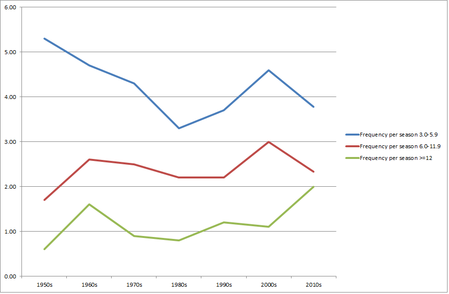
-
December 2021 Obs/Disco...Dreaming of a White-Weenie Xmas
ORH_wxman replied to 40/70 Benchmark's topic in New England
What do you think the average snowfall was by 12/10 in ORH in the 1970s/1980s when you were growing up? Just want to see if your memory matches the empirical data. -
That was exceptional there. I think the jackpot was near a foot or maybe even a little more and a large area in CT got 6-10”. We didn’t get much this way though which is why I excluded it. I think we had about 2-3”.
-
That one was incredible down there...some spots had over a foot in 3 hours. I think even the E Wareham coop had just shy of a foot but the jackpot was just west of them.
-
Actually 2/8/16 may have been one that dropped 4”+ now that I think about it. But that was still over 5 years ago.
-
IVTs are “rare” in the sense that they are modeled way more than they happen...but they actually aren’t THAT rare in an absolute sense. We probably get at least 1-2 per winter. Usually they are like an inch or two though. The ones that produce >4” of snow are definitely less frequent. I could count those on one hand per decade. We had two big ones in back to back winters in Feb 2013 and Jan 2014 in ORH but not sure we’ve had one since then that I can think of off the top of my head. We’re actually kind of “due”. We had good ones on Feb 22, 2007, Dec 19-20, 2007 and then again on December 20, 2008. Then we had one on 2/3/09 to cap off that great 6 weeks in the 08-09 winter before the pattern changed.
-
December 2021 Obs/Disco...Dreaming of a White-Weenie Xmas
ORH_wxman replied to 40/70 Benchmark's topic in New England
LR guidance has been really bad since about mid November. That said, there's some building consensus on a period of mild weather mid-month. Not set in stone though....GEFS have been kind of stubborn. -
December 2021 Obs/Disco...Dreaming of a White-Weenie Xmas
ORH_wxman replied to 40/70 Benchmark's topic in New England
Happened in April 1996 too....something about that year 1996, lol....and Dec 19-20, 2008 and Dec 21, 2008. The twin Feb 1994 storms as well. -
December 2021 Obs/Disco...Dreaming of a White-Weenie Xmas
ORH_wxman replied to 40/70 Benchmark's topic in New England
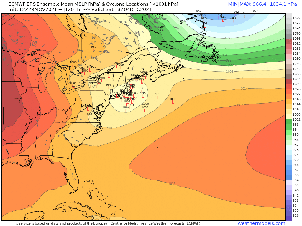
Monday almost looks like just a FROPA on the EPS. Maybe a hint of a wave. Saturday OTOH looked pretty good for a legit system on the ensembles: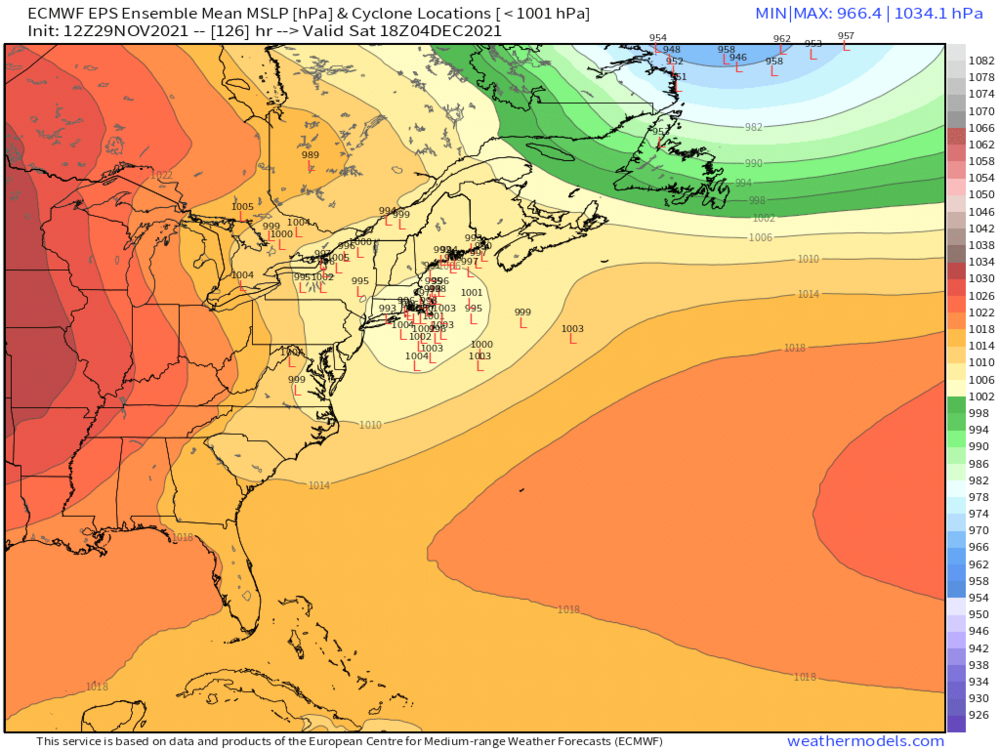
-
December 2021 Obs/Disco...Dreaming of a White-Weenie Xmas
ORH_wxman replied to 40/70 Benchmark's topic in New England
EPS is a lot more bullish for Saturday than the OP and less bullish for Monday. -
December 2021 Obs/Disco...Dreaming of a White-Weenie Xmas
ORH_wxman replied to 40/70 Benchmark's topic in New England
Yeah that's a big hit for 12/6 on Euro...only 7 more days! -
December 2021 Obs/Disco...Dreaming of a White-Weenie Xmas
ORH_wxman replied to 40/70 Benchmark's topic in New England
12/6 is going to come in wintry on the Euro this run....prob a redeveloper look. -
December 2021 Obs/Disco...Dreaming of a White-Weenie Xmas
ORH_wxman replied to 40/70 Benchmark's topic in New England
Euro is a little too flat for 12/4...gets the south coast and Cape with some light snow though. Wouldn't take much though to get a nice stripe over the rest of the region....just need that shortwave a little more robust and not shredded as much in the flow. -
December 2021 Obs/Disco...Dreaming of a White-Weenie Xmas
ORH_wxman replied to 40/70 Benchmark's topic in New England
Both GFS ad Ukie are in on the Saturday/Sat night event. GGEM isn't biting yet....suppressed and flat.