ORH_wxman
-
Posts
93,095 -
Joined
-
Last visited
Content Type
Profiles
Blogs
Forums
American Weather
Media Demo
Store
Gallery
Everything posted by ORH_wxman
-
Wednesday 12/8 Possible Snow/Ice/Rain? Discussion
ORH_wxman replied to Torch Tiger's topic in New England
Yeah probably, but someone may get lucky with 3 or 4" if there's enough LL convergence. -
Wednesday 12/8 Possible Snow/Ice/Rain? Discussion
ORH_wxman replied to Torch Tiger's topic in New England
RGEM likes C/W MA and CT. -
Wednesday 12/8 Possible Snow/Ice/Rain? Discussion
ORH_wxman replied to Torch Tiger's topic in New England
NAM tries to bring some 600mb goodies into the Cape late today...might be something to watch there. I'm a bit skeptical, but can't rule it out. 06z Euro wasn't that far off...just a little offshore with them. IF they got some of that outer ML fronto stuff, they could flip to wet snow for several hours. -
December 2021 Obs/Disco...Dreaming of a White-Weenie Xmas
ORH_wxman replied to 40/70 Benchmark's topic in New England
Even EPS may start offering winter wx chances again around 12/18-12/19. It's not a bad look.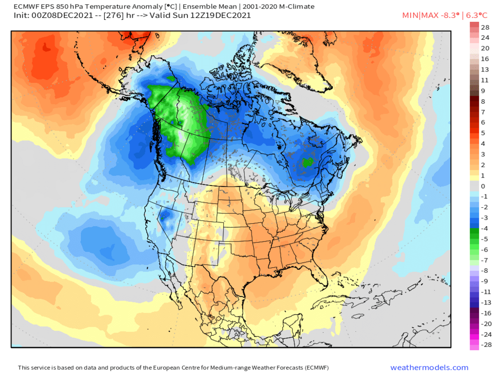
-
Wednesday 12/8 Possible Snow/Ice/Rain? Discussion
ORH_wxman replied to Torch Tiger's topic in New England
Trough axis isn't really stationary long enough to be a NORLUN, but it gets close. The instability is there though. Would like to see a little more LL convergence....here's the NAM sounding near Ginxy tonight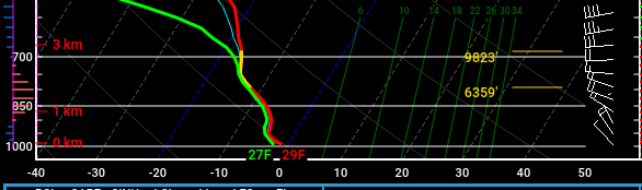
-
December 2021 Obs/Disco...Dreaming of a White-Weenie Xmas
ORH_wxman replied to 40/70 Benchmark's topic in New England
Ensembles trended a bit better overnight. Still a ways out but perhaps Xmas week can be salvaged. Monster EPO ridge... -
Wednesday 12/8 Possible Snow/Ice/Rain? Discussion
ORH_wxman replied to Torch Tiger's topic in New England
Jeez I wake up to like 3 pages of global warming discussion....lol. Model guidance has become more confident in widespread light snows. Someone is prob going to get lucky with a 4”+ lolli too given the nice soundings. It’ll just be a matter of where some LL convergence sets up the strongest and for longest period of time. Good nowcast event at least...these aren’t easy even at 6-8 hours lead time. -
Wednesday 12/8 Possible Snow/Ice/Rain? Discussion
ORH_wxman replied to Torch Tiger's topic in New England
You’re trying to find where the best low level convergence is because that is the primary forcing mechanism. Most guidance has been pretty consistent showing it somewhere between Portland ME area down to RI. The “natural” IVT looks like it wants to go over central/eastern SNE but S ME is always in the game because of the natural shape of the coast there which sort of promotes an IVT. -
Wednesday 12/8 Possible Snow/Ice/Rain? Discussion
ORH_wxman replied to Torch Tiger's topic in New England
Last week was less favorable. Moisture was really lacking aloft which is not the case this time. Most people will prob miss out in this but I do think it’s going to set up somewhere. -
Wednesday 12/8 Possible Snow/Ice/Rain? Discussion
ORH_wxman replied to Torch Tiger's topic in New England
00z NAM back with the strong IVT for central/eastern areas of SNE. -
Wednesday 12/8 Possible Snow/Ice/Rain? Discussion
ORH_wxman replied to Torch Tiger's topic in New England
Not sure...but I figured after the holidays you’d be relaxed and may accept your fate of a record snowless winter in Tolland. -
Wednesday 12/8 Possible Snow/Ice/Rain? Discussion
ORH_wxman replied to Torch Tiger's topic in New England
Just log off and return after New Years all refreshed. -
December 2021 Obs/Disco...Dreaming of a White-Weenie Xmas
ORH_wxman replied to 40/70 Benchmark's topic in New England
Yeah and it's also possible the downstream ridging is overdone (or the extent of the western PNA trough)....I know I don't have to tell you that even if you displace that eastern ridge by a couple hundred miles to the south, we'd probably be quite cold as the northern edge of the positive 500mb height anomalies are quite cold underneath...that arctic airmass will be sloped of course. -
December 2021 Obs/Disco...Dreaming of a White-Weenie Xmas
ORH_wxman replied to 40/70 Benchmark's topic in New England
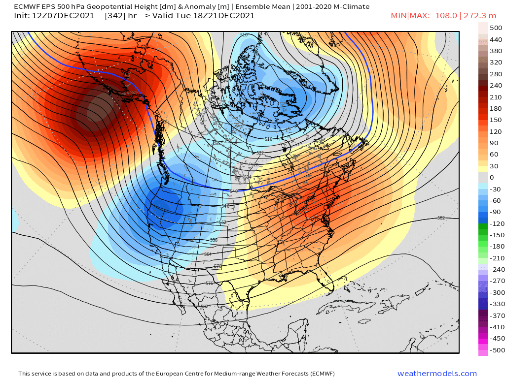
The extreme -PNA is really crushing the east with warmth in the extended. We can usually deal with a -PNA at this latitude, but not when there entire longwave trough is digging down into Baja. Like, here's the EPS at D15....you can see the AK ridge is totally restored...that is actually quite a stout -EPO, but look at how insane that -PNA is.
-
December 2021 Obs/Disco...Dreaming of a White-Weenie Xmas
ORH_wxman replied to 40/70 Benchmark's topic in New England
Last year's grinch storm was an all timer. Prob 95% of grinch storms couldn't melt off 10"+ of pack in 8 hours like that one did....we had grinch storms in 2007 and 2008 which both failed to melt the pack. Last year's was like the Arnold Schwarzenegger of grinch storms. -
Wednesday 12/8 Possible Snow/Ice/Rain? Discussion
ORH_wxman replied to Torch Tiger's topic in New England
Euro was the most paltry out of all guidance down here. It is still showing that finger of snowfall from IVT though S RI up through central MA and S NH. -
Wednesday 12/8 Possible Snow/Ice/Rain? Discussion
ORH_wxman replied to Torch Tiger's topic in New England
12z guidance has actually been pretty consistent with the exception of the NAM going nuts on the IVT....most other guidance is pretty much in agreement on 1-2" for a larger chunk of the region. There will likely be some areas of enhanced rates but you just don't know where they will be. -
Wednesday 12/8 Possible Snow/Ice/Rain? Discussion
ORH_wxman replied to Torch Tiger's topic in New England
Decent IVT sig over RI/E MA that run. -
December 2021 Obs/Disco...Dreaming of a White-Weenie Xmas
ORH_wxman replied to 40/70 Benchmark's topic in New England
Yeah if we assume the model is handling the polar domains fairly well, I'm figuring we end up decently colder than it shows at least up in the northern latitudes. It's really hard to have a ridge in AK and some ridging in greenland and end up torching....I'm not even sure how that happens at all outside of a temporary cutter or something. -
Wednesday 12/8 Possible Snow/Ice/Rain? Discussion
ORH_wxman replied to Torch Tiger's topic in New England
Oh for sure...if it actually verified...someone would prob get 10-12" fluff bomb from that look. The problem as we've been saying, this might set up 200 miles away too. -
Wednesday 12/8 Possible Snow/Ice/Rain? Discussion
ORH_wxman replied to Torch Tiger's topic in New England
The ingredients are there for a good one...we have deep moisture....not dry above like 800mb, lol. Extremely unstable lapse rates occur too. You just need the LL convergence/lift. -
Wednesday 12/8 Possible Snow/Ice/Rain? Discussion
ORH_wxman replied to Torch Tiger's topic in New England
3km hugs the coast with it....congrats Scooter. -
Wednesday 12/8 Possible Snow/Ice/Rain? Discussion
ORH_wxman replied to Torch Tiger's topic in New England
Soundings become extremely unstable. I mean, this is classic heavy snow sounding from an IVT....I do think there's a decent chance something will set up, but we just don't know where yet.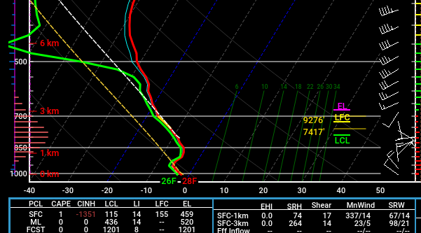
-
Wednesday 12/8 Possible Snow/Ice/Rain? Discussion
ORH_wxman replied to Torch Tiger's topic in New England
NAM gone wild with IVT -
Wednesday 12/8 Possible Snow/Ice/Rain? Discussion
ORH_wxman replied to Torch Tiger's topic in New England
Yeah this is really it....years ago you only had basic QPF maps and had to use experience to interpret snowfall based on thicknesses/mid-level temps, etc.....now you have a trillion weenie snow maps (many of which are awful...in both directions) that every person has access to and it can muddy the discourse quite a bit....esp beyond D5.