ORH_wxman
-
Posts
93,092 -
Joined
-
Last visited
Content Type
Profiles
Blogs
Forums
American Weather
Media Demo
Store
Gallery
Everything posted by ORH_wxman
-
Euro was a big thump for pike region northward. These solutions don’t really matter that much though at 6+ days out.
-
Yeah that looked good on 18z GFS. I’d like to see the vort track just a little further east though like more over PIT/CLE. Otherwise we risk getting a more shredded precip shield.
-
Yes....well not 70, but prob easily cracking 60.
-
Yeah they were always too amped on coastals....but they did WINDEX well. They were also good in icing events...prob mostly due to better resolution than most other guidance back then....I doubt they'd beat out the current hi res stuff in CAD nowadays.
-
The old RSM members on the SREF were excellent in WINDEX events too. Too bad we still can't have them around for winter.
-
It was the 1/28/10 event.
-
EPS is actually reloading the EPO at the end of the run too....we might be in that pattern for a while...maybe through mid-March, but we'll see if future runs break it down faster. The LR hasn't been very accurate this year.
-
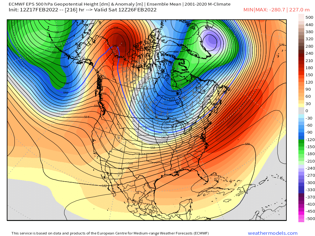
It's hard to have a crap pattern with 200+ DM anomalies at H5 over Yukon/NW territories. If you keep shifting the ridge westward over the Bering Strait and then shove a deep trough into the four corners, then I'd be a little more concerned.
-
Ridge is def further east on this EPS run for the pattern post-2/25. Then it retrogrades a bit back but into an excellent position still and it's associated with split flow.
-
It's a week out....meaningless at this point. But the pattern def favors a colder type overrunning storm with that monster EPO ridge displaced a bit east which is supporting a monster 1040+ high over Ontario/Quebec.
-
Can't buy one all winter. Maybe this is the one.
-
Why are you posting a 153 hour CMC map? That event isn't until like 174-180h, lol.
-
Saturday looks interesting with squalls, but it falls short of the highest events like 1/28/10. The biggest difference was an event like 2010 had saturation up to like 500mb...so you had the instability off the charts whereas tomorrow is more like up to 700mb and then it dries out above that. It's still very unstable but when you cap the cloud tops at H7 instead of H5 or higher, then it lowers the ceiling. But events like 2010 are a high bar...they happen maybe once or twice a decade. But tomorrow does check ALL the WINDEX parameters very well so I would be surprised if there weren't widespread squalls: 1. Big T difference (lapse rate) from sfc to H7 or H5 2. LL moisture pooling ahead of the front 3. Big lift (the primitive checklist used LI spike, but we know there's good lift around with soundings these days) 4. Strong positive PVA to help enhance the lift and concentrate it
-
Yeah you broke 48"....even back in Natick I measured 44" on the level and we got less than you in both the 2/7-9 and 2/14-15 events. Only time I had more than that was March 2001 in ORH when I was close to 48" (measured between 45-52" back then...but hard to know exactly how much it was for sure)
-
That composite loop didn't even include the SWFE threat late next week either. Would be nice to land a beefy warning SWFE event next Friday and then let her rip on this pattern for 2-3 weeks and see how much ground we can make up.
-
One of these years, Kevin will get his 2012 prediction correct.....we actually had back to back Marches like that in 1945 and 1946. Not happening this year.
-
You can see from the EPS animation, it's basically a standing wave over the PNA/EPO region.
-
That is so ridiculous. That's Feb 2015 vibes on that map.

-
Do Pinkham Notch
-
Been showing up on multiple runs of GFS/Euro/GGEM. Seems like one of those systems that models are identifying at a long lead time....we'll see though, lol.
-
Yeah the GFS look is cold....12z Ukie is still a torch and GGEM is in between though prob a bit closer to GFS.
-
The Tuesday system is getting colder too. Not convinced that one torches us...certainly for NNE.
-
ORH gusted to 49 knots a while ago...that's pretty good.
-
Pack melting fast here....backyard is mostly melted out....front yard still mostly covered but not for long.