ORH_wxman
-
Posts
93,110 -
Joined
-
Last visited
Content Type
Profiles
Blogs
Forums
American Weather
Media Demo
Store
Gallery
Everything posted by ORH_wxman
-
It was almost 3-pronged….you had the classic SWFE (all snow version) portion on 12/19…everyone gets 6-10” from that. Then on 12/20, we had the CJ/IVT hanging back with those frigid temps. Some places on the coast picked up an extra 6-7” of fluff. Even back in ORH, I had 3” from that. Then on 12/21 we had the late blooming redeveloper….that’s where you jackpotted for SNE playing naked twister with the CF(and really close to coast flipped to rain) and you also getting a piece of the late-blooming deformation zone later that evening to give you an extra 3-4”. I remember you had like 12-13” in that 12/21 portion while I had around 8-9” in ORH.
-
Ha I remember that happening in the 12/19-20, 2007 OES/IVT event. He had like an inch and then started dripping at 34F when the sun came out while it snowed for another 8-12 hours out east with temps in the 20s.
-
Yeah basically inside of 128 got screwed with BL temps. But even out in ORH where we stayed all snow, we got dryslotted horribly after 10 inches. It was a good storm but nothing amazing…and seeing the deformation band out in E NY down to NNJ made it less appealing too.
-
How about one of those really cold early season events to track where there’s ocean enhancement and light easterly flow. Like 12/19-20/08 or something like that.
-
I think he was saying “horrible” in that he didn’t want to experience that winter again down where he is. Despite the March ‘01 debacle down there, it actually wasn’t a bad winter for NYC. They got the big 12/30/00 storm, though 2/5/01 there was excruciating (big snow just to the west) and of course the March bust.
-
It depends if he ends up in the doghouse with his better half if there’s a big snow event in the first week of December.
-
Ok I’m officially in. Put it on my calendar. I’ll prob plan on getting there early for lunch and stay until about 4-430.
-
Problem in New England is we're one of the few places in the United States dumb enough to not have a pipeline to bring all that domestic/cheap nat gas from PA into our region. So incredibly, we get a lot imported from overseas which is why New England pays some of the most ridiculous prices for natgas in the country.
-
I dunno if I’d call that strongly negative. It’s kind of a weird looking map right now. You also want cold waters hugging the AK coast near Canada during a negative PDO and it’s the opposite right now. It’s def negative overall due to the previously stated bath water south of Aleutians but not as negative as it has been the past few months. I don’t expect it to trend much upward either until this Niña dies out.
-
Reflexive defense mechanism for those scared of a crappy winter. There's really nothing else to it. We've already gone over the empirical numbers. Some would rather spout voodoo instead.
-
I’d take snow in July. Id just rather have 65-70 in mid/late October vs 44 and overcast which is often what the choice is.
-
I think it’s also human nature to want an explanation for every deviation. Nobody wants to hear “we don’t actually know why the AO/NAO went through these large shifts over 10 year periods”.
-
CC gets blamed for a lot of stuff, and then it gets memory-holed when that "blame" doesn't turn out correct. CC was causing more +NAO/AO in the late 1990s/early 2000s, and then it all of the sudden wasn't....it "changed" and we saw all these papers about low sea ice and -AO/NAO.....then that "changed" too in recent years when had trouble getting big -AO/NAOs. I've actually asked people about this who work in the field and the answer I get is typically something like "there's a lot of pressure to come up with CC attribution studies"....which is understandable, but I wonder if it starts degrading the quality of the research when we try and rush to attribute 5 and 10 year trends (such as with the AO/NAO) to CC. I think the law of large numbers isn't appreciated enough on some of this stuff....hard to get really confident answers when you are using sample sizes in the low 10s. The only truly robust CC signal we have on winters is warmer temperatures overall (and especially low temperatures), though the temporal/spacial variation is still very large (see central Canada/N plains/N Rockies with a 30 year cooling trend in winter).
-
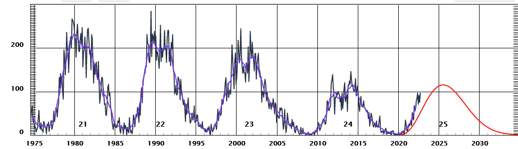
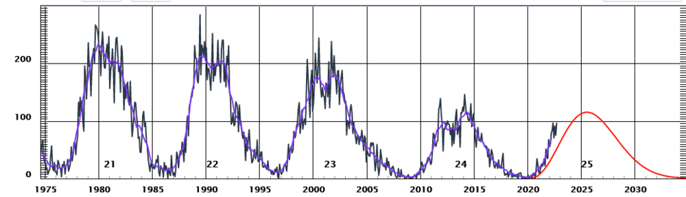
We are still fairly low solar by historical standards....SS24 had a very weak peak.
-
This is correct...it's all how NCDC (or whatever they are called now, NCEI?) split them up way back in the day to organize their climate data.
-
Yeah that would be ideal....but if the 3rd is better for most others, that is fine and I'll organize another one that I can definitely make later this winter.
-
We caught one on our trail cam in the woods behind my house. They are sneaky....hard to ever see, but they are around....esp in areas that have any type of undisturbed woods that are greater than like 10 acre chunks which is pretty common in the Holliston/Sherborn/Hopkinton stretch.
-
I'm not going to be here on the weekend of the 3rd, but I can make the 10th I think.
-
I’ll take a repeat of 2020. It didn’t ruin winter either. I could do without the tropical gales from Havana on Christmas though.
-
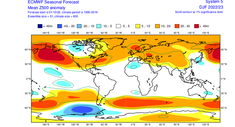
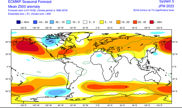
They probably aren't very good because the composites look like this..
-
Dec 2021 is the most negative PNA on record for a monthly value....so yea, people shouldn't be associating a conventional -PNA with December 2021. It's like people associating a conventional -NAO with February 2010. Euro's -PNA is a pretty good look for us since the Aleutian ridge is very poleward and it's couple with a -NAO/AO.
-
I would say the Pacific doesn't look like Dec 2000....that's a -PNA look with the huge heights near the Aleutians and some subtle troughiness near western Canada. But that is still a great look with big poleward Aleutian ridge and -NAO....reminds me a bit more of Dec 2010, though obviously 2010 had pretty extreme blocking.
-
One reason 1965 was so bad is that it was the lowest precip total on record.....but it was already following 2 years of low precip. By itself, it would have been pretty bad, but the fact it came on the heels of back to back very low precip years already made it so much worse. BTW, 1965 is so anomalous, that the 2nd driest year (1910) is closer to 14th place (2016) than 1965's total.
-
1960s was like a 4 year drought which is why it got so bad. That's hard to do around here though which is why all the subsequent "droughts" haven't been able to match it. They have trouble lasting more than a year. 1963-1966 was the last time BOS had 4 consecutive sub-40 inch precip year. IIRC, I don't think we've even had 3 in a row since then. It's difficult to avoid precip around here.
-
Still gotta watch out for some localized heavy downpours through afternoon. There will be more stuff rotating off the ocean.