ORH_wxman
-
Posts
93,092 -
Joined
-
Last visited
Content Type
Profiles
Blogs
Forums
American Weather
Media Demo
Store
Gallery
Everything posted by ORH_wxman
-
Hopefully it retrogrades by December...sometimes it can take a couple weeks to do it.
-
Big torch the next week and a half or so and then changes are coming it looks like.
-
Yeah it's not really feasible to go wire to wire. 1995-1996 did have all 4 big snow months above normal (Dec/Jan/Feb/Mar) but we obviously had that brutal thaw in 2nd half of January. 2000-2001 over the interior did as well. That year is prob the closest since it didn't have any brutal thaws after the 12/17/00 cutter (there were two small snow events in the week after that too which saved white Xmas) Only other one off the top of my head was maybe 1960-1961. '04-'05, '92-'93, and '93-'94 were all close but no cigar. They all had one month that was more like average instead of above avg. '07-'08 prob pulled it off in NNE.
-
They can get some obscene snow totals out there in November. Stuff you just can’t find back east even in our cold airmasses that early in the season.
-
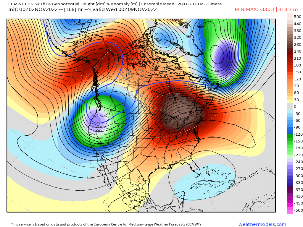
There seems to be plenty of agreement on big AK positive height anomalies by mid month but the PNA region is a little muddier. But it’s been trending “ridgier” out there.
-
That was a great event. Had over 8” in that which then produced a white Tday a week later because it really didn’t melt much. Had the coldest November day on record in most spots on Tday that year too.
-
OH i can see that too....my suet feeder is usually hogged by the larger woodpeckers but we do get the chickadees and nuthatches on it when it's free. Blue Jays use it too, esp in winter. I really need to get one or two more.
-
OP GFS trying to hit the PNA ridging too mid-month and beyond. It also produces the first snow threat in that time which would certainly be a possibility if we were able to get that type of western ridging and cold delivery. Ensembles will be more useful than OP runs, but they are all showing the same general theme today.
-
Chickadees don't sit and eat at bird feeders.....they typically grab one seed and then fly to a nearby branch or perch and eat the seed there and then return to the feeder for another one. Rinse and repeat. Titmice and nuthatches behave the same way. We have a ton of them that come to my feeders....prob seen 6-8 chickadees at once before near the feeders but typically not all on the feeder at the same time as they are in different stages of flying to and from the feeder after grabbing a seed. Years ago, I read one theory on why those types of bird do that and it was because their beaks aren't strong enough to crack open sunflower husks, so they need to peck at it while holding it down on a branch to open it. Finches, grosbeaks, cardinals, etc all have much stronger beaks that can crack open the sunflower in one shot.
-
Yeah when the EPO block "Folds over" itself, the next upstream trough tends to rejuvenate it in the PNA domain or at least closer to the PNA domain....you can kind of see it when we loop the EPS from about day 7 through D12.

-
The western ridging over PNA region is a new development out in the extended EPS. That would make the change more abrupt after mid-month. We'll see if it sticks.
-
Def not fake if the non-rad spots freeze. That’s usually pretty chilly during daytime too on those airmasses.
-
Euro and EPS both are trying for a cold shot around mid-month now. Might be the first freeze for the non-rad spots. FWIW, ORH latest freeze on record is 11/12 (1977 and 1916) This year has a legit shot to break that record.
-
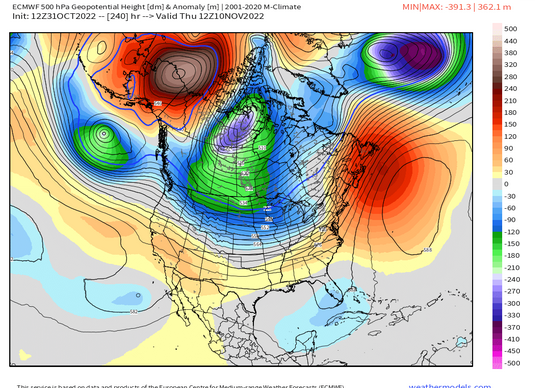
Euro also shows some of the Scandinavian ridging retrograding into Greenland at the end of the run....if that happened, that will also help push the lower height anomalies further east toward Lakes/New England rolling forward. So it's another perturbation to watch.
-
That D9-10 setup.....They usually can't get storms that cold in mid-January out there, nevermind early November.
-
Yep....though none of it matters without the QB. Jets would prob be a playoff team with a real QB. Too bad Breece Hall got injured. He looked like a stud in the making. Hopefully he comes back good next year.
-
I like the N PAC look on EPS....good -EPO. Still -PNA but we can deal with that....esp as the wavelengths lengthen.
-
First hand accounts of hurricane of ‘38 is expected now….
-
Yeah I guess that makes sense. I remember we didn’t hear about it for years and then all of the sudden the schools were all telling us to be careful of candy. Maybe it goes in phases/cycles….you get a couple incidents and everyone freaks out for a few years and then it dies down until the next incident. My kids haven’t heard of anything like that yet so we must be in a down phase of compromised candy. The only memos we’ve gotten in the past few years were to double check that candy wasn’t accidentally edibles that someone handed out…lol.
-
Yeah “poison in the candy” or “razor blades in the candy” was definitely a 1990s thing. I first remember hearing about it in the early 90s. Maybe even late 1980s. Then it kind of went away within a decade.
-
I think this time 11 years ago we were reading all those obs from southern CT where brief RA- flipped to snow and many started as straight snow. That’s when I was thinking “this is prob overperforming somewhere”….no QPF wasted.
-
Pretty heavy frost here even on the hill. Kind of surprised.
-
Devil's advocate is easy to play 5-6 weeks out too because model guidance isn't very skilled at that range.....almost anything can happen. There could be a massive pig over AK that the models don't see right now. But all else equal we'd rather not have the weeklies show it even if they aren't very skilled 5 weeks out. At least the more skilled ensembles at 2 weeks out show no sign of a terrible N PAC pattern which I think is the first thing you'd want to eliminate if you are trying to avoid a disaster (a la Dec 2011, 2015, etc)
-
These forums didn't start getting popular 20 years ago because of record high temperature enthusiasts.....you know that though since you were on them back then. Winter wx has always driven the traffic aside from some legit hurricane threats.
-
Forky pretends to hate winter wx.