ORH_wxman
-
Posts
93,095 -
Joined
-
Last visited
Content Type
Profiles
Blogs
Forums
American Weather
Media Demo
Store
Gallery
Everything posted by ORH_wxman
-
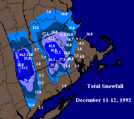
I actually have to extend that 20" contour further northeast to near Ray's current location (Groveland coop had over 20" from that event). I noticed it a few years ago but never updated it. Also have to extend it SE past my current area. The really tight gradient is near Walpole/Franklin.
-
Almost Halloween....time to give Scooter nightmares.
-
"I can't believe I got 12"!!!" (when every single model had an inch of QPF all snow with the dynamics to support it)
-
Both the reverse psychology and the over-zealous positive hype are manifestations of emotion over science and objectivity. They both degrade the integrity of the discussion from a scientific standpoint. Everyone is susceptible to it, but controlling it as much as possible will lead to more accurate forecasts and better dialogue.
-
Hype sells, but reverse psychology is also rampant on here. Just downplay and poo-poo every event so you can convince yourself that you are not "invested emotionally" in a winter or a storm threat.
-
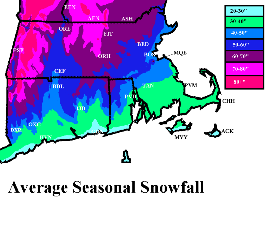
Foxborough itself is actually not bad for snow....gets more than Boston does being southwest inland and a few hundred feet in elevation. If you want, say, another 10-15" per year and a bit better retention, then you'll want to move northwest of Foxborough out toward ORH...but as someone already said, that's a bit of a haul. IF you don't mind an hour commute though, then it works. Best spot near ORH is probably on west side in the town of Paxton or some of the high spots in Holden. My current area (Holliston/Hopkinton/Ashland) is a bit closer and maybe 30 minutes away but probably gets 10" more than Foxborough with better retention. Hopkinton esp is good because it has a lot of spots over 500 feet in elevation. Here's my crude SNE annual snowfall map i made years ago. Foxborough is basically halfway between BOS and PVD in that band of 50"+ that extends southeast from the main dark blue area.
-
What did you get there? About 30 inches in that storm? There were other storms that month too which were good over the interior.
-
Yes it was still a good event inland but we spent most of that storm watching messenger post about heavy bands down in that area. Ray made a comment about the storm being a little lame compared to a few of the meso model runs early that morning and messenger posts about how good it is down there and then Ray just goes off about cranberry bogs and nobody giving a crap about the 5 people who live there…LOL. Just classic.
-
That’s when Ray went on his infamous Cranberry Bog rant….one of the all-timers. LOL.

-
Yep obviously. Lol. Still had a good pack on Xmas after the cutter on Xmas Eve but man, we were so close to currier and Ives perfection that year.
-
It was almost 3-pronged….you had the classic SWFE (all snow version) portion on 12/19…everyone gets 6-10” from that. Then on 12/20, we had the CJ/IVT hanging back with those frigid temps. Some places on the coast picked up an extra 6-7” of fluff. Even back in ORH, I had 3” from that. Then on 12/21 we had the late blooming redeveloper….that’s where you jackpotted for SNE playing naked twister with the CF(and really close to coast flipped to rain) and you also getting a piece of the late-blooming deformation zone later that evening to give you an extra 3-4”. I remember you had like 12-13” in that 12/21 portion while I had around 8-9” in ORH.
-
Ha I remember that happening in the 12/19-20, 2007 OES/IVT event. He had like an inch and then started dripping at 34F when the sun came out while it snowed for another 8-12 hours out east with temps in the 20s.
-
Yeah basically inside of 128 got screwed with BL temps. But even out in ORH where we stayed all snow, we got dryslotted horribly after 10 inches. It was a good storm but nothing amazing…and seeing the deformation band out in E NY down to NNJ made it less appealing too.
-
How about one of those really cold early season events to track where there’s ocean enhancement and light easterly flow. Like 12/19-20/08 or something like that.
-
I think he was saying “horrible” in that he didn’t want to experience that winter again down where he is. Despite the March ‘01 debacle down there, it actually wasn’t a bad winter for NYC. They got the big 12/30/00 storm, though 2/5/01 there was excruciating (big snow just to the west) and of course the March bust.
-
It depends if he ends up in the doghouse with his better half if there’s a big snow event in the first week of December.
-
Ok I’m officially in. Put it on my calendar. I’ll prob plan on getting there early for lunch and stay until about 4-430.
-
Problem in New England is we're one of the few places in the United States dumb enough to not have a pipeline to bring all that domestic/cheap nat gas from PA into our region. So incredibly, we get a lot imported from overseas which is why New England pays some of the most ridiculous prices for natgas in the country.
-
I dunno if I’d call that strongly negative. It’s kind of a weird looking map right now. You also want cold waters hugging the AK coast near Canada during a negative PDO and it’s the opposite right now. It’s def negative overall due to the previously stated bath water south of Aleutians but not as negative as it has been the past few months. I don’t expect it to trend much upward either until this Niña dies out.
-
Reflexive defense mechanism for those scared of a crappy winter. There's really nothing else to it. We've already gone over the empirical numbers. Some would rather spout voodoo instead.
-
I’d take snow in July. Id just rather have 65-70 in mid/late October vs 44 and overcast which is often what the choice is.
-
I think it’s also human nature to want an explanation for every deviation. Nobody wants to hear “we don’t actually know why the AO/NAO went through these large shifts over 10 year periods”.
-
CC gets blamed for a lot of stuff, and then it gets memory-holed when that "blame" doesn't turn out correct. CC was causing more +NAO/AO in the late 1990s/early 2000s, and then it all of the sudden wasn't....it "changed" and we saw all these papers about low sea ice and -AO/NAO.....then that "changed" too in recent years when had trouble getting big -AO/NAOs. I've actually asked people about this who work in the field and the answer I get is typically something like "there's a lot of pressure to come up with CC attribution studies"....which is understandable, but I wonder if it starts degrading the quality of the research when we try and rush to attribute 5 and 10 year trends (such as with the AO/NAO) to CC. I think the law of large numbers isn't appreciated enough on some of this stuff....hard to get really confident answers when you are using sample sizes in the low 10s. The only truly robust CC signal we have on winters is warmer temperatures overall (and especially low temperatures), though the temporal/spacial variation is still very large (see central Canada/N plains/N Rockies with a 30 year cooling trend in winter).
-
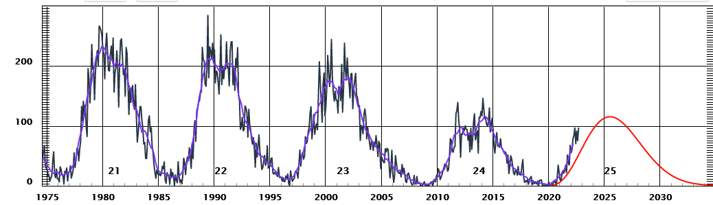
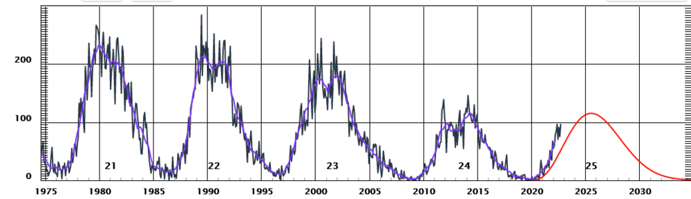
We are still fairly low solar by historical standards....SS24 had a very weak peak.
-
This is correct...it's all how NCDC (or whatever they are called now, NCEI?) split them up way back in the day to organize their climate data.