

ORH_wxman
-
Posts
93,095 -
Joined
-
Last visited
Content Type
Profiles
Blogs
Forums
American Weather
Media Demo
Store
Gallery
Everything posted by ORH_wxman
-
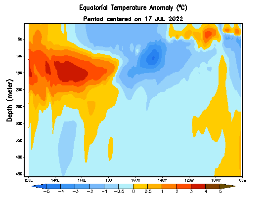
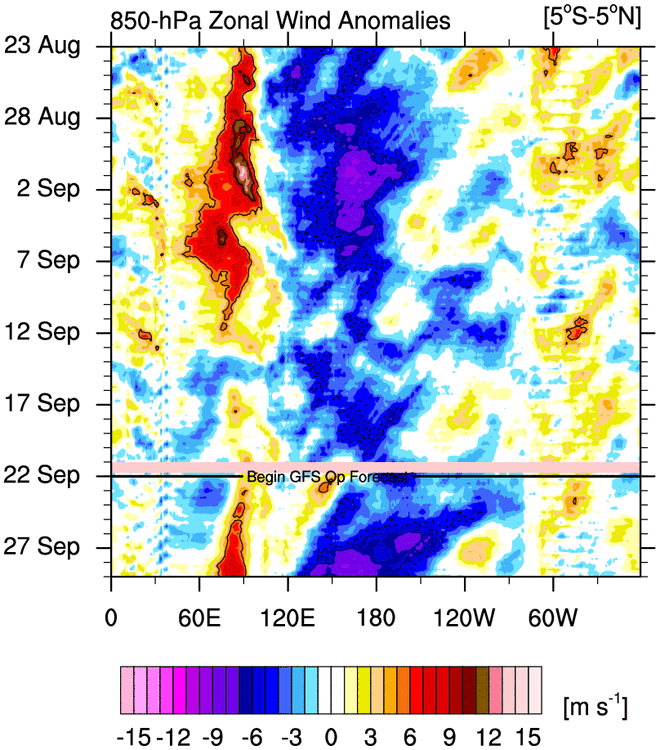
I think we'll know a lot more in the next 2-4 weeks on if this ENSO event will get one last surge into solid moderate territory or if it will just sort of straddle the line between weak/moderate. There's still very strong cold anomalies just lurkeng below the the sfc and the easterlies are forecast to pick up. Theoretically, we should see a strengthening of the Nina from this, but if it doesn't happen, we can prob stick a fork in anything stronger than low-end moderate. The previous round of easterlies though had trouble getting east of the dateline....so we'll see about this one over the next week.
-
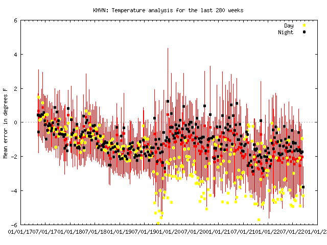
Yeah this seems to be a bug in MADIS checking all the other sites. They all seem to have this weird step-change on high temps around that time. I checked inland sites too like ORH, MMK (not too far form HVN), and IJD. What's weird is it doesn't seem to affect the night temps at all.
-
MADIS isn't always the most reliable, but HVN high temps look they have run really warm for a few years now. Starting in late 2019/early 2020 it seems like the high temps went wacko.
-
Update and verification of prediction earlier this season: On 9/20, the NSIDC extent had risen to 4.75 million sq km which puts it 130k above the minimum of 4.62 million sq km several days ago. It is pretty safe to call the minimum at 4.62 million sq km. This extent is 7th highest (or 9th lowest) since 2007. Both 2017 and 2018 finished at 4.63 million sq km.....barely higher than 2022. Area continues to rise too now at 3.6 million sq km, but we reached the minimum on that 9 days ago at 3.2 million sq km. The 3.2 million sq km area minimum ranks 5th highest since 2007....only 2009, 2013, 2014, and 2018 were higher. The reason area ranked higher than extent was that the ice pack was more compact this season than other years like 2021 and 2017 which had lower area numbers but higher extent minimum. The predictions quoted above were for area to finish at 3.00 million sq km (+ or - 300k) and for extent to finish at 4.6 million sq km (+ or - 500k). Verification fell within these predictions (and almost exactly for extent), so I am glad to see that the meltponding continues to be a very accurate predictor of minimum extent/area. I don't do predictions for volume, but PIOMAS volume minimum has likely been reached as well at 5039 cubic km.....which is the 10th lowest in the record. It is the highest minimum volume since 2015.
-
57 is rare in Sept under full sun. Usually you need precip for highs in the 50s in September. If we end up with more clouds, could easily be like low 50s. Hilltops in SNE don’t freeze that early. It would be the earliest freeze on record at ORH airport if that happened.
-
61 and socked in still....I'm all set with soupy upper 70s/low 80s.
-
Yeah rainfall could easily finish above normal at CON...prior to each cold shot, there will be a chance for some convective rains ahead of the front, so it will depend on that. But the temps look locked in pretty good.
-
ORH and BOS will prob finish below normal too.
-
Kind of hard to see how it doesn't finish below normal with the current model progs....could always change, but it would have to be pretty drastic. CON was +0.2F on the month coming into today and we have 2 pretty big cold shots on the models over the next 10 days.
-
58.6 and mist here.
-
Update: We've reached the minimum on NSIDC area....area on 9/18 was 3.47 million sq km which is 270k higher than the minimum so far this year. Losing 270k after 9/18 hasn't happened in the record and there's no reason to think this year will be different looking at the weather up there. So the minimum will go down as 3.2 million sq km on 9/12. Extent may or may not have reached the minimum yet. Extent on 9/18 stood at 4.68 million sq km. This is currently 60k above the minimum of 4.62 million so far this month, so there is still a low probability we fall back below that 4.62 million sq km number, but it's becoming more unlikely by the day. If extent rises over the next couple of days, we can probably safely call it.
-
That GFS cold shot is ridiculous for later next week. Prob record cold in a lot of spots. Would prob have a lot of first flakes of season in NNE too and even down into Berkshires/Monads/etc. Euro isn’t quite as crazy and is probably more reasonable. Still quite cold though.
-
2020 had that ridiculous stretch around the equinox. CON set 3 consecutive record lows (almost had 4)
-
First frost on the forum?
-
I’m on the NW edge of that gradient in Holliston. It rapidly decreases southeast of me. Between here and like Wrentham or Plainville is only like 15 miles but the difference can be night and day. Snow cover often rapidly decreases. Even between here and Norfolk/Walpole…though Walpole does a little better since they have some sneaky elevation.
-
Sometimes I feel like the longitude at which storms most rapidly deepen south of us plays a role. You start seeing that dryslot wrap in while it’s still over E LI into S RI but by the time it migrates eastward, the rapidly deepening midlevel centers are collapsing everything E and SE and it fills in by the time it reaches, say, TAN to PYM corridor.
-
I think it’s a fluke. Dec ‘92 didn’t screw N RI like Mar ‘13 did. Woonsocket over to Burrilville got annihilated.
-
You’d do well on a more easterly flow like a Dec ‘92. Regular coastal with winds more NNE don’t provide enhancement there….the rare westerly flow event does well there too.
-
Yeah some of those scrapers can give PTSD in the interior. But in my long experience with central MA wx, I feel like as long as you are on the east slope of the ORH hills, higher elevation is going to equal more ice and more snow. The extra elevation outstrips any other variable when you are still on the east side of the spine. Once you go west of the spine far enough, things change since you start to lose the orographic enhancement on easterly and northeasterly flow.
-
My guess is you get both a little more ice and a little more snow there.
-
No he must be up by Justice hill in Sterling...i don't think anywhere else is in town is high enough to be over 800 feet.
-
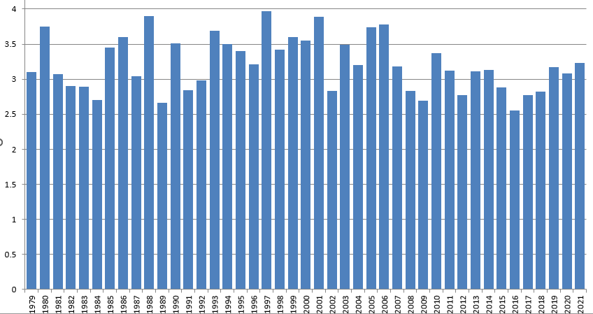
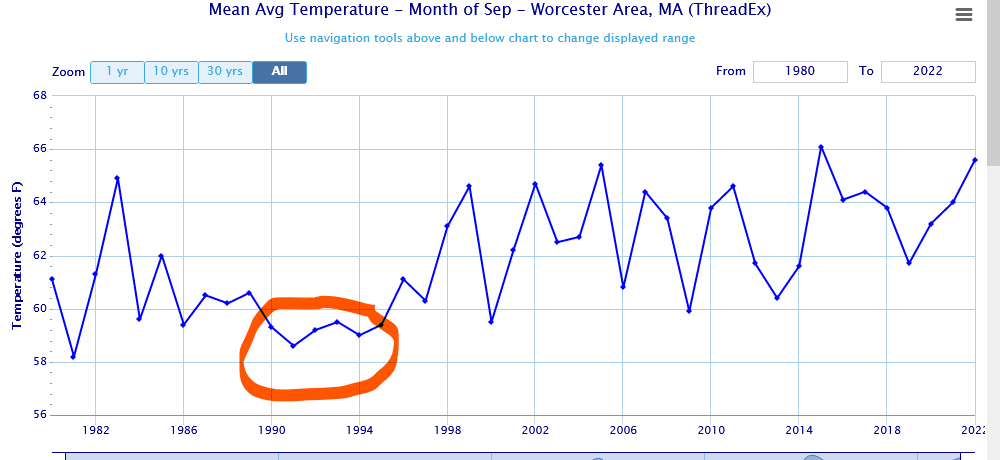
We had some cold Septembers back then....they show up well on the time series:
-
Took ORH until noontime to reach 60F under full sun. Pretty decent airmass for mid-September....esp compared to the most recent 10 or 15 years (Sept has been one of the warmest months relative to avg)
-
Update: NSIDC area stood at 3.28 million sq km on 9/15. There is a good chance we've reached the minimum already, but we're still close enough (80k higher than min) that we can't call it quite yet. NSIDC extent continues to fall though, down to 4.65 million sq km. So we likely haven't reached the min yet on extent. I'll do a full verification of earlier prediction on 7/1 once both area nd extent min have been reached.
-
Shortwave behind that tracks into Quebec....need it further south for a good SWFE.


