ORH_wxman
-
Posts
93,095 -
Joined
-
Last visited
Content Type
Profiles
Blogs
Forums
American Weather
Media Demo
Store
Gallery
Everything posted by ORH_wxman
-
Rap gone wild north of the pike.
-
Nickels and dimes are great around the holidays....gives it that great holiday vibe....but still, I am not sure I'd ever trade in a true monster storm for them. But since we've already had a dumpster fire season during the heart of cold/pack climo, there's no way I'd even think about preferring a bunch of nickel and dimes in late Feb and early Mar over a 30-burger. Late season is also big dog season....seasons in seasons as Kevin would say.
-
or 2016.....
-
What is the empirical basis of this statement as it pertains to our current guidance? It's a pretty clear outlier amongst all guidance that goes out far enough to see this system. Ukie/GGEM/Euro/Icon (if we want to include) are all pretty much on the same page synoptically....Euro juices it to another level, but the track is similar on all of them while the GFS is significantly further north and late with the redevelopment. I wouldn't completely discount the GFS, but I'd place it significantly less likely to verify than the other suite of guidance.
-
Everyone's grading system is their own. But I'd forgive a lot of sins if we got a 30"+ snowstorm....even in a winter like this. I wouldn't give it a good grade, but I'd prob elevate it to like a C or C-.
-
HRRR doesn't do that and neither does the Euro....NAM is the only one that erodes it all prior to round 2. It's gonna be hard to dislodge it once it oozes down....you need a legit mechanism to move that dense air. Right on the water it would be easier if you can turn the flow onshore, but I don't see how you remove it from, say, the 128 belt.
-
Pretty awesome continuity for an OP run that far out. Though as Tip and I were just discussing...it's almost an inevitable outcome once it reaches the Ohio Valley 36-48 hours earlier. So you'd expect to see good continuity when some of these larger scale features are not moving much.
-
Colder in BOS than upstate NY
-
There's no doubt the block raises the ceiling....it creates an opportunity for a slower system that wouldn't be possible without the block (never mind the track would also be a cutter without the block). But I'd like to see ore continuity on that round 2 insert.
-
Yeah, I'd caution everyone not to get married yet to the Euro enhancement from that second shortwave.....that's what turns a 6-10" storm into a HECS/KU type solution, but that first aspect of the storm is becoming a lot more likely. We'll see if we can get the nitro-boosted prototype that the Euro/EPS are selling as we get closer.
-
Right...agreed. Once it reaches a certain point, it has nowhere to go except to track into the favorable zone. The block is creating more margin for error than a typical "unmanned firehose" type setup where tiny perturbations create large final differences in outcomes....but with that block and the pacific flow upstream forcing this system to hum along to the east into that block, it's really game set match once it hits the Ohio Valley around 120 hours.
-
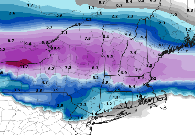
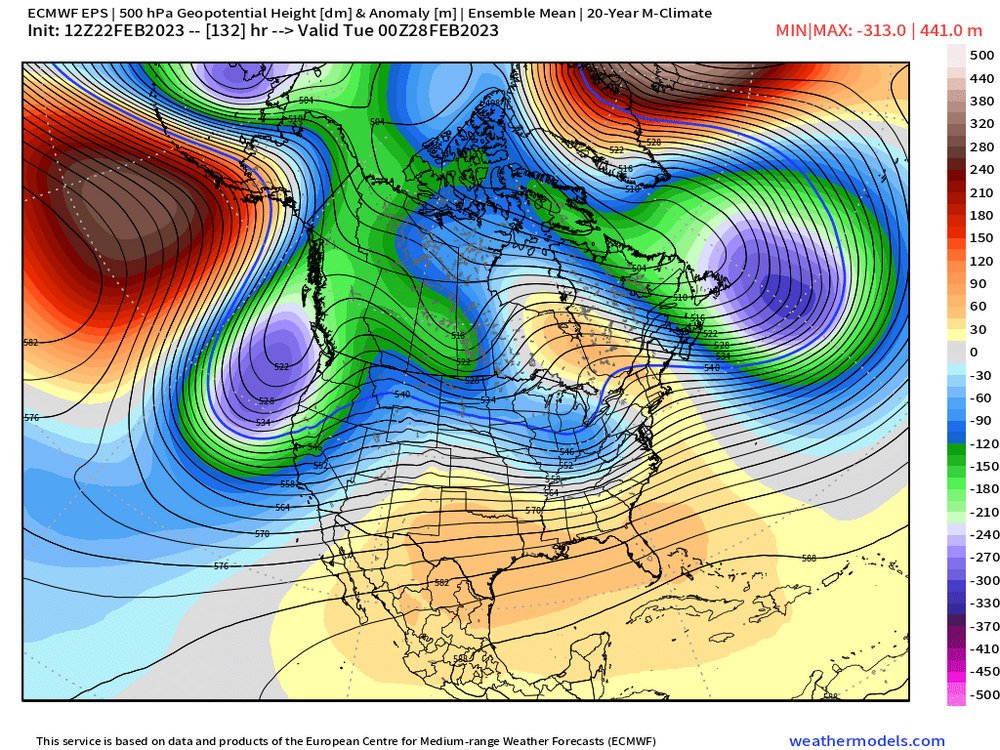
Yeah the Euro has the snow moving into western CT by 132 hours and all of SNE by 138 hours....it's not a 200 hour fantasy at this point. There is still time to screw this up, but it will need to reverse the trends we've seen the last 24 hours fairly quickly. IF we're seeing huge Miller B solutions still at this point tomorrow, now we're like 108 hours out and that's getting into pretty good skill range for guidance.
-
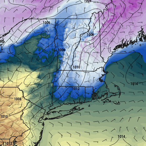
I wouldn't expect more than a tenth or so....maybe some of the high terrain gets a little more, but most of the danger comes with just a thin glaze of freezing drizzle when temps really drop tomorrow. There could be an additional tenth or so of glaze tomorrow night as that 2nd round of light precip comes through
-
Yes...the mini-split flow little Hudson Bay block/ridge is a very classic feature seen on so many of our Miller B storms. It all starts with the Atlantic car pileup from that developing block.
-
A few posts up....brooklynwx has an animation comparing them
-
Get that trailing shortwave north fo Montana/Dakotas to catch up with it right as it's nuking south of us....then get a 12-18 hour stall/bombogenesis there.
-
Synoptically, this is pretty classic for SNE Miller B. Ohio Valley shortwave running into a blocked 50/50 low
-
The last time we had a threat inside of 6 days that was this good-looking was probably last winter. 12/16 did look pretty good but not sure it ever really got inside of 6 days....the last great runs we saw on that one were during the 12/10 GTG when the Euro tried to reincarnate Dec '92....but then it turned crappier almost immediately after those runs. 12/23 looked good until about D7. This is prob the closest we've been all winter to a modeled warning snow event.
-
EPS definitely not holding back


-
This is like that stretch in 1956....one after the other every 2-3 days...just don't tell Ray.
-
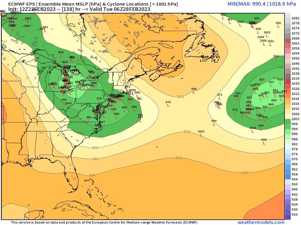
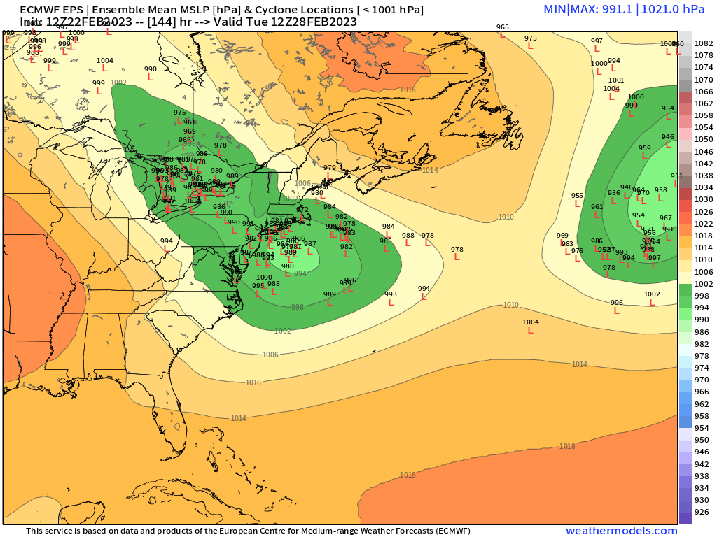
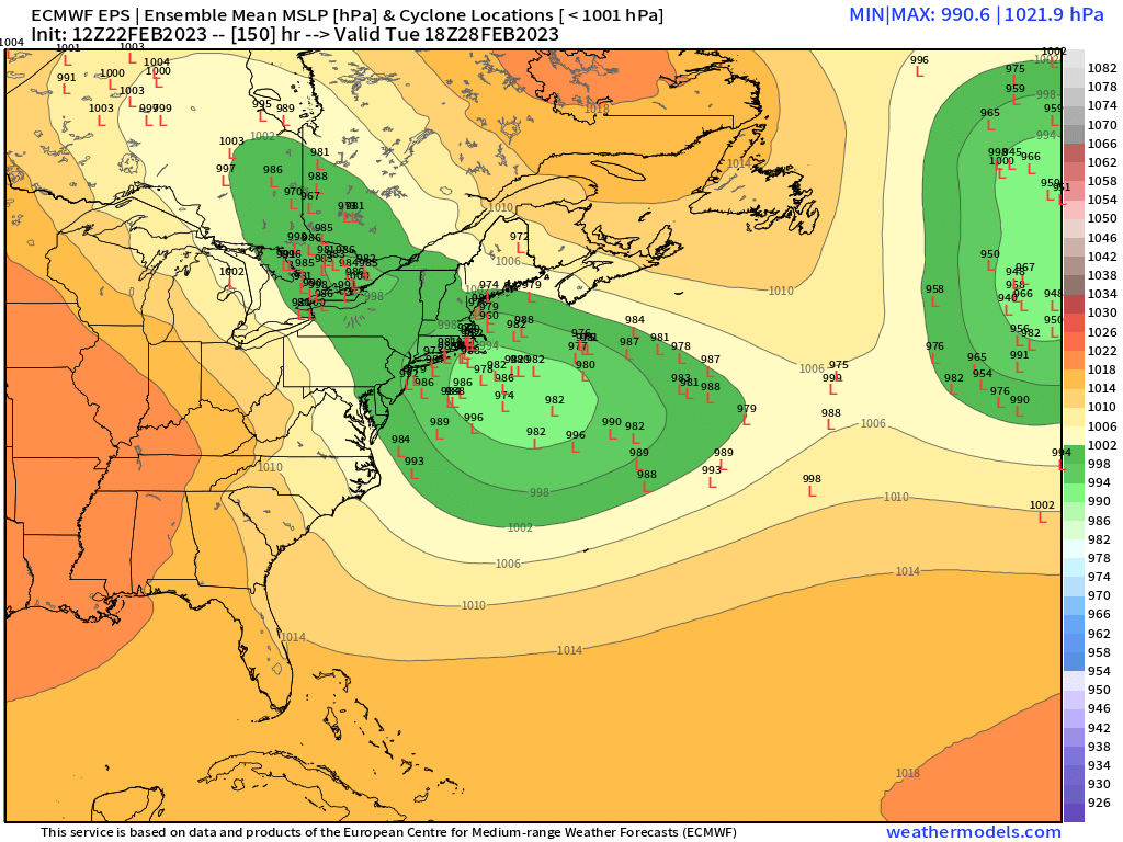
Ukie is on board for 2/28....redevelops it quick enough similar to GGEM.
-
LOL, it actually does but it's too phased and taints us.
-
Lets try and phase a piece of that PV lobe into the D9 system on GGEM ala March 4-6, 2001.
-
Yeah it redevelops quick enough and moves almost due east south of SNE
-
Good step in Euro direction that run....hopefully we keep trending that sucker.