

ORH_wxman
-
Posts
93,095 -
Joined
-
Last visited
Content Type
Profiles
Blogs
Forums
American Weather
Media Demo
Store
Gallery
Everything posted by ORH_wxman
-
Mostly marginal I think until we get the cold drain later in the event prior to round 2.
-
Scooter highs of yore…
-
Yeah it has trended surprisingly little in the past 2-3 days....guess we'll see if we can get one last colder push for us pike to rt 2 dwellers, but I doubt any major changes are coming. I kind of expect some tiny little ticks north/warmer in the final 24 hours here, but who knows....maybe it will throw us a bone for 6 hours tomorrow evening. As much as we joke about the model dopamine drip, I do actually like watching snow falling from the sky, so it would be nice to get 6 hours of moderate to heavy snowfall for once this winter. Been an utter dearth of snow lasting more than about 2 hours this season and a vast majority of them were like today....33F grass/car top jobs that start melting immediately after it falls.
-
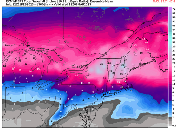
EPS has been hammering NNE the last few cycles....ski areas should be looking great heading into 2nd week of March. We'll see if we can finally cash in here...we haven't seen ensemble runs this snowy all season for SNE, but we obviously have less wiggle room than NNE in this pattern.
-
Yeah it was super zonked the last couple runs. Synoptically, it seemed very likely it would come south some.
-
The 12/11 event while we were waiting for the epic 12/15-12/31 period was the equivalent of Apollo’s jabs on Drago in the opening part of the first round. Everyone’s thinking it’s going according to plan….
-
That one is worth watching. Even down to here. The antecedent airmass is solid so it wouldn’t take much to turn that into a really good storm. Of course, that would require us catching even a mild break which has been about as effective as Apollo Creed against Drago this winter.
-
Even there i’d still prefer the base of that block to have a bit more latitude than it does (see how it’s almost coming in from the southeast instead of more from the east?). But yeah, verbatim you see a really strong 50/50 response to it which would serve us well. I just want to have more wiggle room as we get closer.
-
Euro will “win” the battle but in 70/30 fashion as to surgically give us little or no snow and keep most of the goods N of rt 2 or MA/NH border.
-
Pretty decent pike thump but there’s not a lot of wiggle room. I’d love to get 3 or 4 inches though before the pellets.
-
East based blocking tends to be better when we have a serviceable pacific pattern. When the pac is mostly dogshit like it will be coming up, you want that block to maximize confluence and cold in southeast Canada…that would be in the form of a greenland/Davis strait block that comes in from the east. We do NOT want the block coming in from the south, that just won’t get it done with the pacific like it is. It needs to come in more from the east bexause that will be way more efficient at pinning the 50/50 subvortex there.
-
Did you think it was going away? Pretty much everyone keeps saying the pacific isn’t changing. Our help is going to have to come from the Atlantic side which already leaves New England with not much wiggle room. NYC is even less.
-
Yeah there is a complete disconnect synoptically right now with NAM and others. It’s basically dryslotting us before any real robust precip. That’s separate than a simple sounding disagreement.
-
They taint your area. NAM might be too far north synoptically..which is the thing to watch. We know it can handle the elevated warm layers well, but it only matters if it is correct synoptically. If it is simply just too far north with the storm, then it will be wrong. I think Euro/GFS are likely too cold aloft here but the magnitude will matter a lot…esp for those more up near NH border.
-
GFS decided to cool slightly. Decent thump for MA. At some point either the NAM or the globals are going to make some noticeable moves.
-
2nd batch is where the cold tuck could be dangerous. Still not seeing much trend so far at 12z. NAM still an absolute furnace and we don’t even get much precip from round 1. Dryslotted. RGEM cooled a tick (lot of sleet after brief snow) ICON cooled even more, has a pretty decent thump on the pike kind of like the euro. Im guessing NAM is too amped but the colder models are too flat if someone held a gun to my head.
-
All about how the block retrogrades. If it sort of stays shunted south of greenland, then it’s not gonna help us much and it will prob stay fairly mild. If it can retro into greenland, then you will get a better response south of it in SE Canada and New England which would prob give us several opportunities. But if it’s one of these deals where it meanders over the North Atlantic and then tries to poke into the Davis strait from the south, that’s mostly hot garbage in a -PNA. Most of the uglier solutions are some version of that where the fun solutions are not.
-
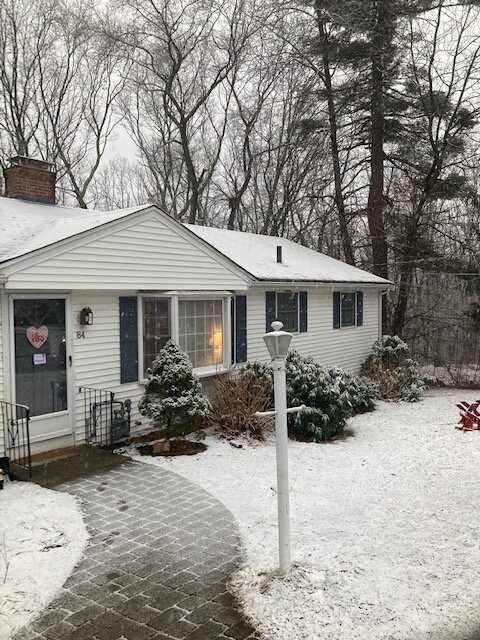
Looks a little like winter at least
-
Euro suite is the coldest now. Pretty safe to toss I’d say. Unless we see others all of the sudden come back south today.
-
Steady snow here. Maybe a few tenths.
-
I’ll be bummed if I can’t crack 10”…but we take the small victories where we can this winter.
-
18z euro likes the pike. Pretty similar to RAP/HRRR. Not overly robust, maybe a couple inches in that zone with C-1” outside of it.
-
2/28 solution was run off runnawayiceberg’s computer.
-
18z GFS drank too many beers while grilling dinner this balmy evening. It decided to go full-on weenie with 2/26 and 2/28 back to back.
-
3k seemed to start as snow while 12k was a furnace. My gut says we don’t get much snow in the pike region for 2/23, but Everytime I convince myself of that, the non-NAM runs keep singing a different tune. Hopefully we get a little more clarity tonight.


