-
Posts
93,092 -
Joined
-
Last visited
Content Type
Profiles
Blogs
Forums
American Weather
Media Demo
Store
Gallery
Everything posted by ORH_wxman
-
Yeah a lot of these 12z runs so far are pretty weak sauce with the precip rates this evening....I'm envisioning a lot of 1 mile vis light snow that accumulates slowly on the grass with maybe a heavier burst in the final hour before it flips. I was hoping for 3-4" but I haven't really strayed from my personal thoughts of an inch or so.
-
Antecedent airmass is actually decent out ahead of the storm....it's just a question of the block being good enough to force redevelopment soon enough to hold in that airmass....if not, then we erode it and get a pseudo-cutter, but on the Euro, it redevelops and we're good.
-
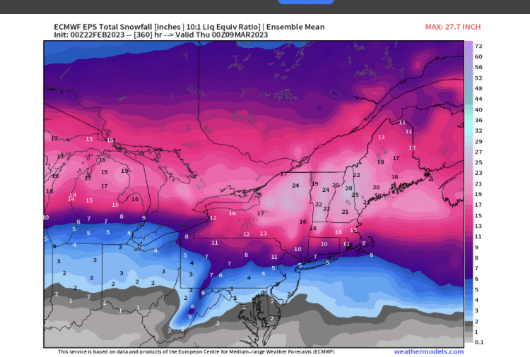
Thing is, we haven't seen this depiction all winter...it's been like 100 miles north of this with the best over Canada border region usually. So even if this is too far south, it's going to bode well for a large part of NNE/CNE.
-
-
-
Sometimes it produces especially weenie solutions when it decides to hang out with Crazy Uncle at happy hour.
-
I’ve noticed the PV has been extending/elongating just a hair SE on these colder runs lowering the heights in NE. I’m not entirely sure on the reason we are seeing those little wobbles. Might be how it’s interacting with today’s shortwave. I think Tip’s overall larger view has been very correct on this one…that PV is a monster and isn’t going to move very easily so it’s that versus the western trough and the forces are pretty equal at the moment. But since your area in the NH border region down to mine near the pike is right on the line, we’re sweating these 15 mile wobbles whereas nobody in NYC gives a crap and powderfreak doesn’t give a crap either…it’s mostly been the same solutions for them outside the “marginal zone” where we are.
-
It’s amazing how many airmasses have lacked low level cold this year even when aloft is decently cold. So many winters we’ll have random events with 528 to 534 thickness and temps in the 20s. But this year, we’ll be like 528 thicknesses with 850 temps of -6 and 925 temps of -3 with sfc temps in the mid 30s with white rain falling. Lol. Cannot buy a surface high in even a half-reasonable position this winter. Tomorrow’s event is one of the first times all year where we have a good sfc high…ironically we lack a decent antecedent airmass ahead of it so we are still struggling anyway….hopefully one of these events beyond tomorrow can do the trick.
-
Scooter highs of yore…
-
Yeah it has trended surprisingly little in the past 2-3 days....guess we'll see if we can get one last colder push for us pike to rt 2 dwellers, but I doubt any major changes are coming. I kind of expect some tiny little ticks north/warmer in the final 24 hours here, but who knows....maybe it will throw us a bone for 6 hours tomorrow evening. As much as we joke about the model dopamine drip, I do actually like watching snow falling from the sky, so it would be nice to get 6 hours of moderate to heavy snowfall for once this winter. Been an utter dearth of snow lasting more than about 2 hours this season and a vast majority of them were like today....33F grass/car top jobs that start melting immediately after it falls.


