ORH_wxman
-
Posts
93,095 -
Joined
-
Last visited
Content Type
Profiles
Blogs
Forums
American Weather
Media Demo
Store
Gallery
Everything posted by ORH_wxman
-
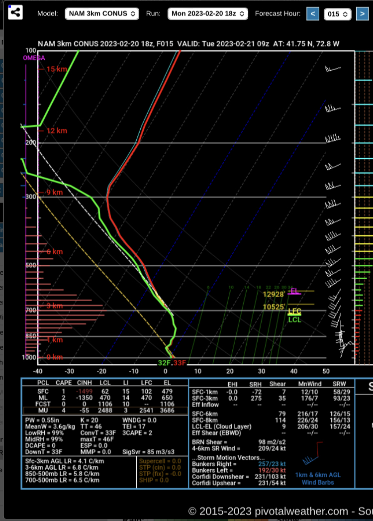
Here’s the 3k sounding near BDL at 09z. Looks pretty cold actually just off the deck.
-
That’s a map that starts at 1pm Tuesday so it would miss anything overnight and tomorrow morning.
-
Yeah it’s really deep lift. Kind of weird how strong and deep the omega is on the NAM but not so much other guidance. It does seem to be leading the trend on 2/21 though. But prob good to hedge quite a bit here.
-
3k beefed up too from 12z.
-
Starts ripping in CT by midnight or so. Could be an interesting sensible wx shock…people grilling dinner at 55-60F in CT this evening to parachutes falling with several inches already OTG when they wake up. Other mesos continue to be a bit more tame but they still have it. More like 1-2” or so.
-
I don’t think it’s full-on winter yet on guidance…we’re still dealing with how the NAO block manifests and interacts with the pacific state. There will definitely be chances but we could easily mix in a warm storm or two. We have a much better shot at trending storms colder than previously, but that doesn’t mean they all will. Theres a lot of uncertainty there. At the very least, there’s more reason it stay up for the 00z runs these days. We’ll see if we can get this block to retrograde into a good position ala 2018. But I’m still leery of a more subdued and warmer version of the pattern.
-
It just doesn’t really rip it southeast like some guidance which is what the “tuck” part of cold tuck is really defined by. It actually cools during the day Thursday over the interior though…obvious cold drain going on there but not the same as the tuck south/southeast.
-
I think we could start an obs thread late tonight as a compromise. The model analysis can stay in here for the next 12 hours on the 2/21 stuff.
-
Looks colder in low levels too. All of it may be related though…just like better omega leads to colder temps, colder temps initially (or via advection during the early stages) make a tighter thermal gradient is going to lead to better QPF too.
-
And equating it to someone posting ensemble analysis was pretty horrendous.
-
Yeah they frequently don’t pan out because you need the low levels saturated which inherently is difficult when you are advecting in colder air. But this is an example of when it’s more likely to verify than usual.
-
The stronger the NAO develops behind that threat, the more likely it is to come in colder. Basically, if the Archambault signal comes in more robust, we’ll likely have a better shot at snowing there since that 50/50 would be doing a better job of wave breaking that retrograding block to accelerate it. If the NAO phase change looks weaker, then the storm is warmer.
-
The 2/21 impulse actually has two parts to it (kind of like how 2/23 does too). That second part is more for NNE. But recently a more southern wave has tried to develop ahead of round 2.
-
Those hilly areas north of the Merritt might be a decent spot tomorrow over to Ginxy and N RI hills.
-
Haven’t really seen any 12z trend. NAM went warmer, GFS went colder, GGEM was maybe a tick colder but really close and Ukie looked a tick warmer as it comes back to earth a bit from being the cold outlier at 00z when it had warning snows into CT.
-
Other guidance has it at 12z so far, just not nearly as robust as the NAM. But GFS has a little stripe too of 1-2”. Something to watch anyway.
-
How is that analogous to posting 384h OP runs? Good grief…ensembles are posted all the time. Just because they didn’t verify, doesn’t mean they are invalid discussion and they are certainly not the same as posting an operational run that far out.
-
The thing that makes it somewhat “dangerous” is the cold tuck accelerates right before that 2nd pulse of precip comes in on Thursday night. So if some areas had warmed up to mid 30s or something like that after the initial snow/sleet, a lot of people will think the worst is over but then all of the sudden it dumps back down to 28 and the next wave of precip is coming in. That’s how it could be especially nasty. GFS actually shows this too at 12z.
-
A few inches of snow here turns into an absolute paint peeler on the GFS. It’s cold in the low levels.
-
GFS is coming in colder now too. So it doesn’t seem like the 06z runs were necessarily a start of a consistent trend. Lot of wobbling going on really if you look at the past 4-5 cycles.
-
Icon actually came in a decent tick colder. Has a nasty cold tuck over eastern areas too…temps crashing into 20s. That’s prob the top hazard in SNE…flash freeze potential for the areas that go from a quick burst to snow to IP to cold 34-35F rain but then it quickly falls to 27F with little notice. Still a possibility this ends up as mostly a sleet bomb too after an inch or two of snow.
-
I mean, it has. This 2/23 event is already quite a bit south from what it was 2-3 days ago. But we’re fighting other variables too. The lead 2/21 wave isn’t the only thing affecting this.
-
Rgem has the Tuesday morning stuff too but much weaker with it. Maybe a coating to an inch type deal south of pike.
-
Keep the politics off the wx side please.
-
Would be pretty fitting. Throws a tantrum and then is shoveling 4” of snow the next day.