ORH_wxman
-
Posts
93,092 -
Joined
-
Last visited
Content Type
Profiles
Blogs
Forums
American Weather
Media Demo
Store
Gallery
Everything posted by ORH_wxman
-
Yeah though it was a bit more subdued and a tick south of the 06z run which was even more wild. Still a really good solution for a lot of the forum though.
-
Pivotal https://www.pivotalweather.com/model.php?m=rdps&p=500hv&rh=2024010412&fh=84&r=conus&dpdt=&mc=
-
RGEM was pretty wild. Just nukes out near ACK.
-
I miss when the SREFS were half-useful for winter event. The old ETA/RSM mixture.
-
Powder blizzard for 3-5 hours to finish?
-
NAM has the explosive ending during Sunday PM.
-
Dude, it's the Henry the VIII song. Or watch the movie "Ghost"
-
Could get nasty sunday PM....a lot of places that were getting paste will freeze pretty quickly as temps crash into the 20s.
-
FWIW, the 06z EPS tracks really close to the 06z OP run....maybe a bit SE of the OP run.
-
06z GFS gone wild. Double digits for most of SNE.
-
Uncle looks to be staying sober this evening. A solid warning event for many but not the higher end type solutions.
-
Much colder GFS run but GGEM went significantly warmer. GEM was so cold at 12z that even the warmer 00z run is still a decent thump (esp over interior)…we’ll see if euro can cool more. It’s been the stubborn one despite cooling some at 12z.
-
The front running wave is much stronger on the GGEM so it never really allows the trailer to crash the party. It keeps the downstream ridging in front of the trailer to a min. But when the front runner is that potent, you still get a big solution.
-
The vort being very weak and sort of paralleling the coastline rather than moving out to sea is helpful. It doesn’t sweep the baroclinic zone well out to sea. Having the trailing shortwave play a role on almost every run now is good for setting a higher floor on this event. I think a total or near-total skunk job is becoming pretty unlikely. The key is now going to be if we realize the higher potential if we can get those two shortwaves optimal.
-
Front runner is weak sauce but that trailer is still barreling in on its heels. This run will prob still be good, tho maybe not quite as good as 18z.
-
ICON sort of escaped east before capture but an improvement over 18z. Pretty solid low end warning event for most of SNE. Really close to getting eastern areas with several more inches.
-
Yeah it was mostly today when our main shortwave starting coming onshore. It’s a good sign that 00z has only strengthened that type of solution…albeit with the caveat that we’re still on the JV models for a 3.5 day threat. I’ll be more moved by NAM and RGEM solutions in another 36h.
-
If we can get through another 24h of model guidance trending toward that type of interaction, then it’s time to start honking big. Still guarded at the moment because we’re in that awkward zone where things can rapidly still change but that window is closing quickly over the next couple cycles.
-
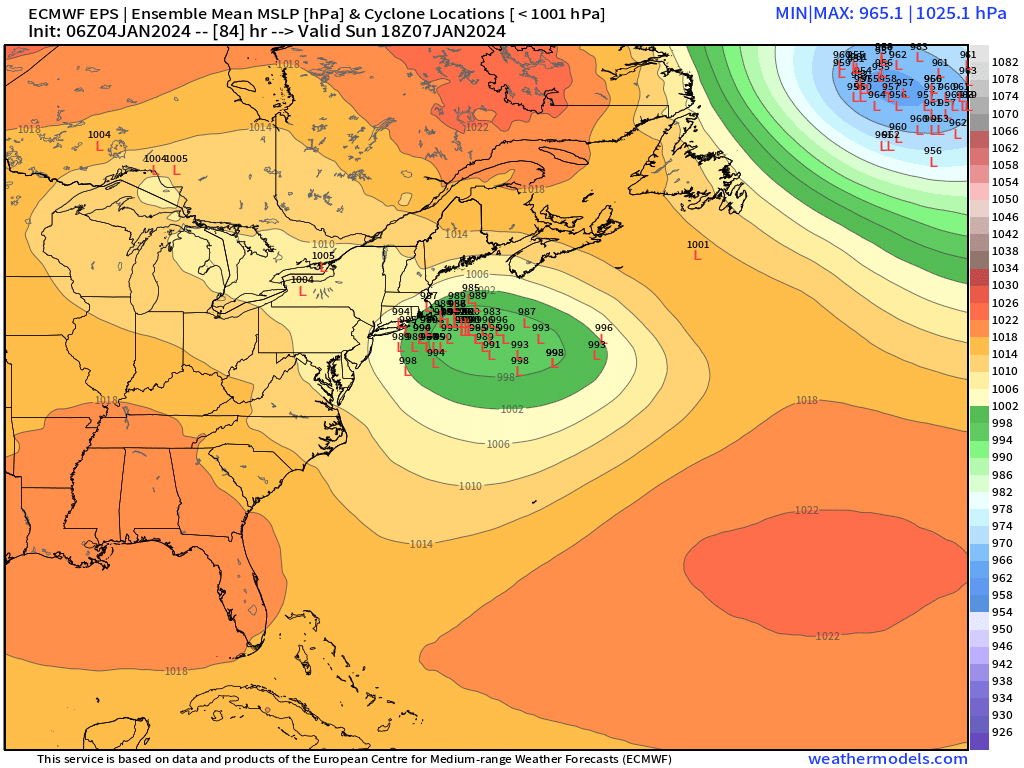
Yeah at 84h you basically have a bent back WF in the midlevels quasi-stalled near the south coast….inject that with the trailing vort and start rapidly deepening the ML center and ohhh boy….that’s how major positive busts are born. Check out 00z reggie too…kind of similar though not quite as perfect with the trailing vort.
-
NAM was prob gonna go apeshit the next frame with that potent vort trying to crash the party. That gonna be a feature to watch…if there’s going to be a decent swath of double digits, that trailer vort is likely the key. We’ve seen several model runs do it already. But as Tip and others mentioned, it’s still delicate…if the trailer vort doesn’t quite get it done or the timing is slightly off then it won’t work and you’re left with a good, but not major event.
-
1/29/22 if I’m nitpicking…tho technically it did start right before midnight.
-
Reggie at 84 looks like a big hit....keeps that front runner s/w intact long enough. Kind of gives an idea of how long we've been tracking this one given that we're only getting into clown range for NAM/RGEM. Still plenty of time for changes.
-
We were lucky if the 0C 925 line was SE of ORH, lol. So many events were so marginal and a lot of it was because we had zero high pressures in a decent spot.....the 1/7 event finally has a decent high that is able to funnel down good air into any CCB.
-
NAM still looks like it would mostly be the trailing shortwave. It did take a bit longer this run to grind up the lead shortwave so maybe it will eventually trend toward other guidance.