ORH_wxman
-
Posts
93,099 -
Joined
-
Last visited
Content Type
Profiles
Blogs
Forums
American Weather
Media Demo
Store
Gallery
Everything posted by ORH_wxman
-
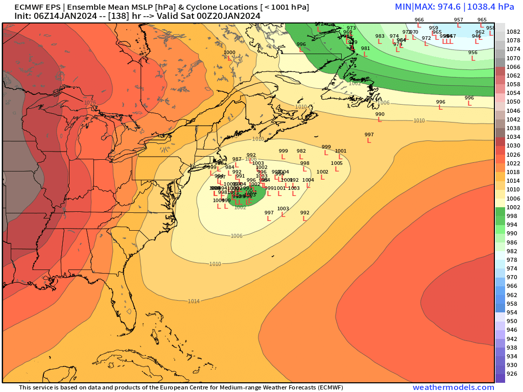
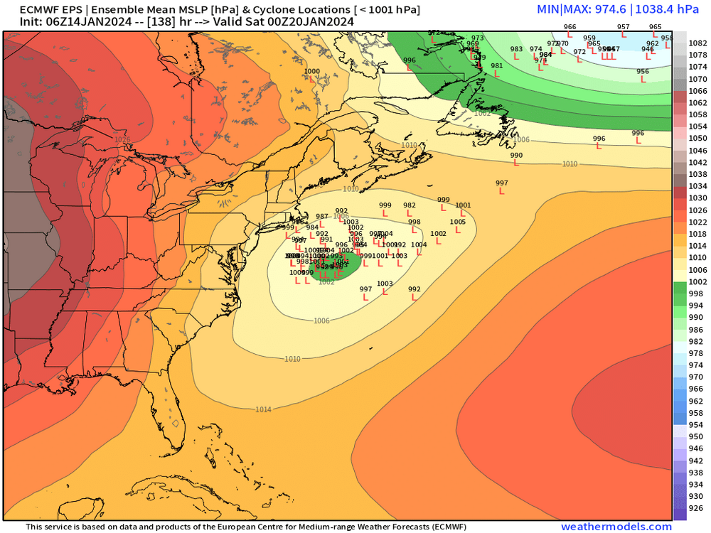
06z EPS was decent too
-
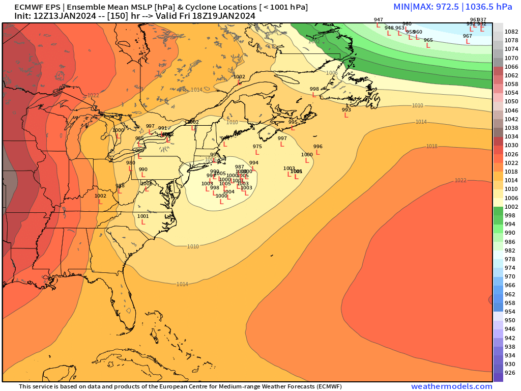
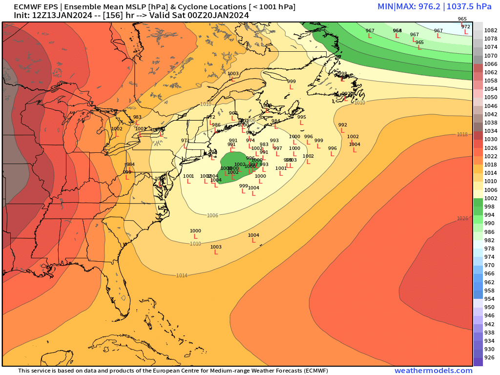
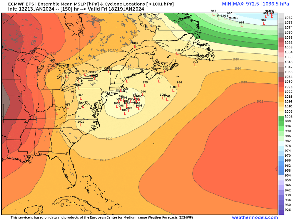
Yeah that’s a substantially better look for 1/19-20 on 18z EPS.
-
That was a great storm. I had about 20” in that. That month was crazy.
-
Improvement on the euro but still not much of an event. But maybe 1-2” for many that run.
-
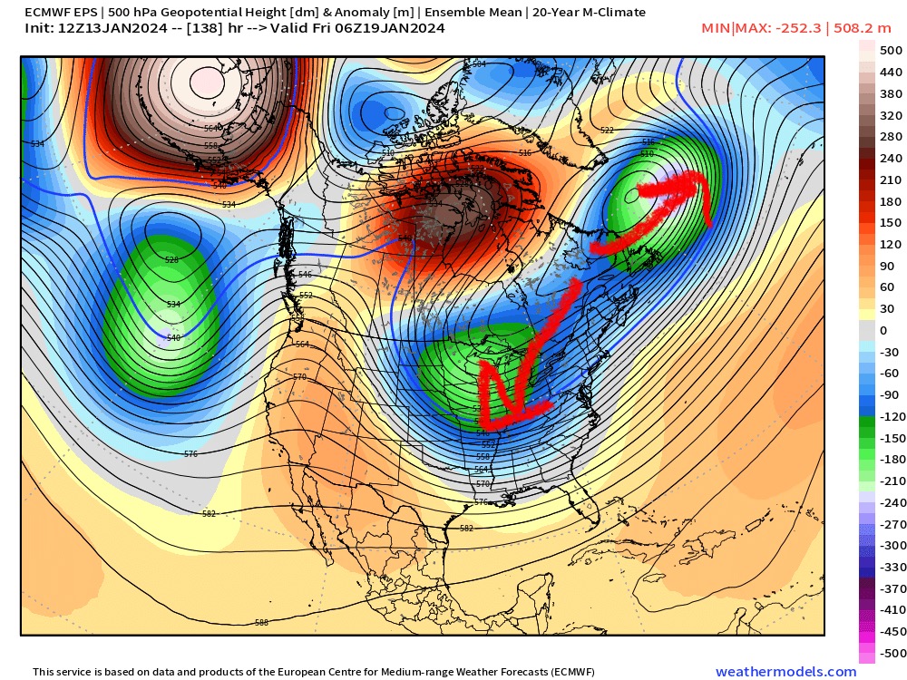
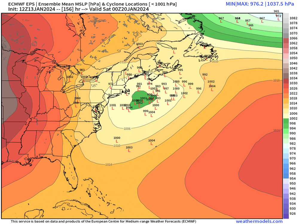
It actually does move into that position by the PV splitting…see the EPS image below….ideally that piece that goes southwest trends a bit further southwest to give us more room to amplify…I think that’s important, especially further south.
-
PV is actually getting a bit stretched. One piece breaks off and becomes a 50/50 low and the other gets pulled back SW and becomes a key player for 1/19-20. But yeah, you don’t want it over us or you get suppression. Ideally, you have it sitting over the 50/50 position or just west of it and waiting to block a cutter shortwave which turns it into a monster snowstorm coastal. In order to get the PV stuck in that position, usually a -NAO block is helpful which is why we often like them. But you obviously can have too much of a good thing sometimes.
-
Starts out in PA but it gets better as it heads east and the mesolow tries to form. Someone could pick up advisory snowfall if they get a little mesolow pivot…we’ll see if that develops or not but most likely spot would be NNE…can’t rule out a bit further south though for the beginning of the enhancement. Should at least be interesting to track.
-
18z OP GFS was a little better but still not much but the GEFS def ticked much better.
-
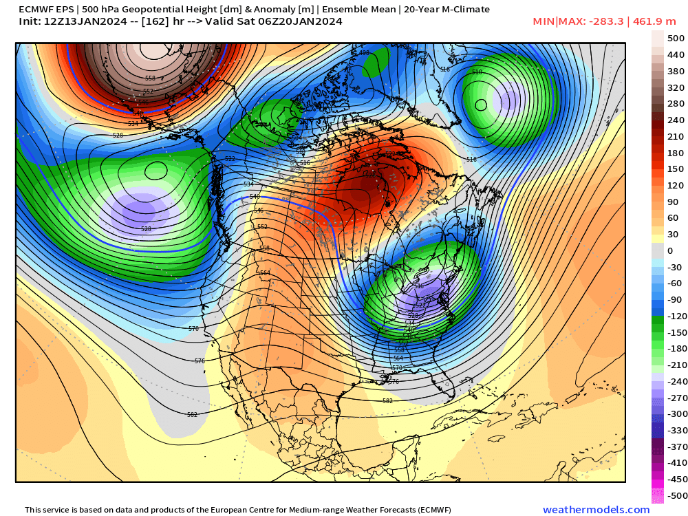
GFS wasn’t as enthused with 1/19-20 on 18z run but still really close. Verbatim like a 4-8” type event. What you want to look for in that event in future runs is the PV lobe being stretched far to the southwest so that it has room to amplify along the coast.
-
If people want to act like children and complain about every threat, they can do it elsewhere. There are still people who log on here to read about the meteorology and actual model discussion of a threat.
-
We haven’t had a GOA low almost all winter which is typical strong Nino.
-
It’s actually trended better since 00z but this forum has become an unreadable dumpster fire.
-
EPS sig for 1/19-20 is def there. Needs a bit of work but not bad for d7.
-
It depends on like 3-4 different factors. Today we mixed out like 8C at 850…classic downslope dandy. You’re gonna shoot 55-60F when that happens. But if we’re in a low mixing environment with 0 to +3 850 temps, then you’re talking 40s for highs. If theres a cutter involved, then you can spike much higher. OP Euro (extrapolated) and OP GFS show how you just get some mundane above normal stuff before the reload…but we’ve had some GFS runs that go warmer too.
-
Hopefully we can avoid any major torching. GFS kind of shows how. We get some days in the 40a but no warm rainstorms. Then pattern reload out west toward month-end which makes sense since all the ensembles show that too as MJO goes back around to phase 6/7
-
Some other notable WINDEX events I remember: Feb 10, 2008 Feb 2, 2001 Mar 3, 1996 Nov 23, 1994 Dec 1, 2003 We had a good one in I think Feb 1989…awful winter but good squall that dumped a quick inch can’t remember exact date though. The 1/28/10 event though was by far the largest for me since it dumped a quick 4”…the 1-2” events happen every now and then but 4” is rare outside of the mountain-enhanced terrain spots.
-
Ukie still has a solid advisory snowfall over a large part of New England. Guess we’ll see if Euro wants to come back.
-
The key is what dendrite said above…you get a piece of the PV phasing into it and that typically helps bring it north some.
-
GFS is gonna go big this run for 1/19-20
-
No I’m actually in a great mood today…3 day weekend, lol. But it’s getting toward mid-January now…preseason is long over. People can leave this thread if they are not interested in this event any longer. Go to banter for the “winter sucks” talk.
-
ICON/NAM/RGEM all have something at 12z. The mechanics of this event look fairly fleeting, but they’re all showing an area of decent lift moving through quickly on Tuesday which would be enough to support advisory snowfall in a decent stripe where that occurs.
-
I just cleaned up this thread…what an embarrassment for some of you. Act like you’ve posted on the forums before and didn’t just get here from accuwx forums. This is still a storm thread. If you have no interest in this event, then don’t post in here again. Go to the banter thread. That’s what it’s for.
-
Yeah 06z looked a bit better. We’ll need another improvement at 12z.
-
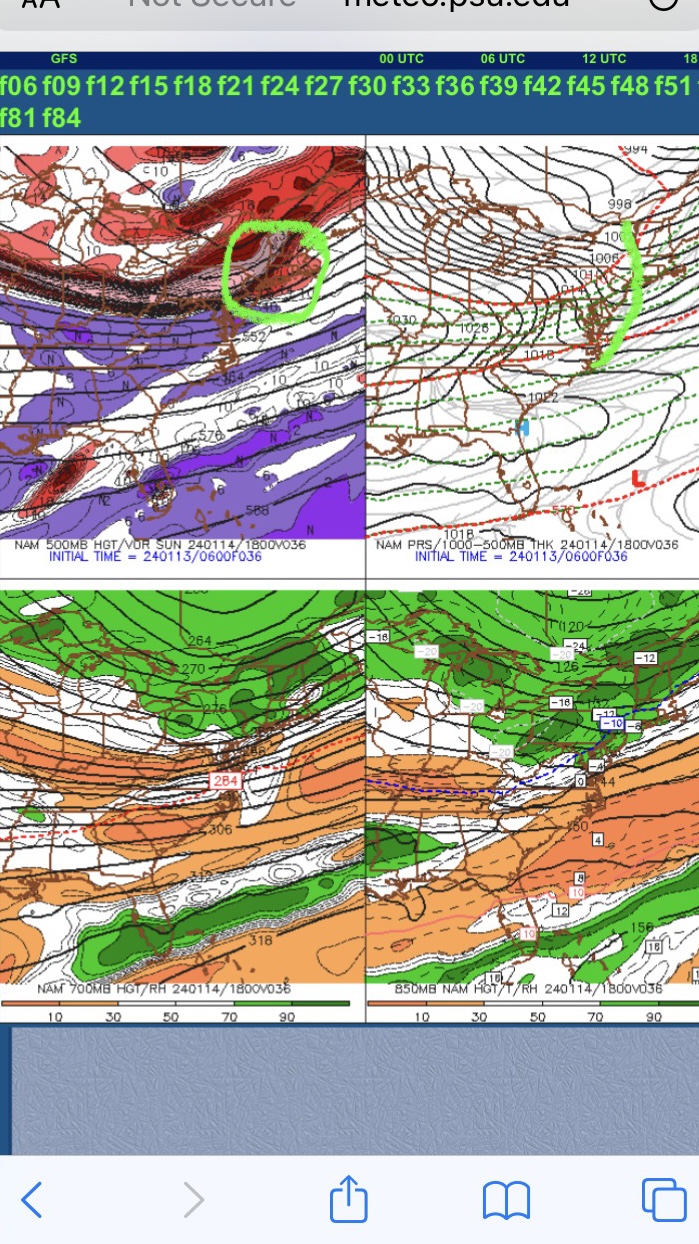
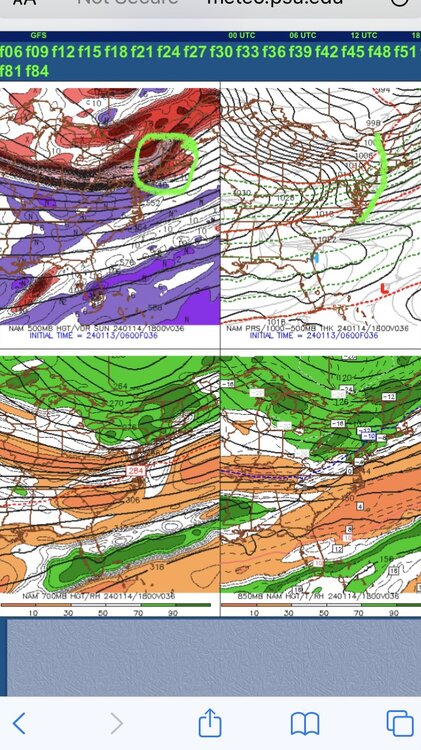
Figured I would start a different thread for this because it has continued to improve on model guidance over the past 24-36 hours. Sunday afternoon is starting to look pretty prime for some squalls. If we go over our old school WINDEX checklist, we look for below ingredients: 1. Low level moisture 2. steep lapse rates 3. strong LI spike (source of lift) 4. Cyclonic PVA (really this just enhances #3, but it can make an event higher end) All 4 of these ingredients are present in a pretty big way on Sunday. We have LL moisture in the 65-90% range which is excellent. We have extremely steep lapse rates (TTs near 60!) and saturation up to around 600mb Have a huge LI spike of 16-18 in 12 hours and to assist that we have strong PVA with that nice shortwave. Below is the 06z NAM for tomorrow afternoon…you can see where I circled the potent vortmax (there’s our strong PVA) and then you even have a sfc response from with that clear kink in the isobars (marked on the right)…that helps veer those winds to more southerly component ahead of the front which is what we like to see because it helps pool moisture…same thing we look for in warm season Tstorm/severe threats. These types of setups are where you can pick up a quick 1-2”…perhaps even an isolated higher amount if you get into some good squalls…in addition, we’re going to have rapidly falling temps from the mid 30s down into the lower 20s within a few hours, so we’ll need to watch for flash freeze on roads in some areas.
- 365 replies
-
- 21
-

-

-

-
00z suite all trended the wrong direction. So that’s basically putting a fork in anything sizeable. There’s still a realistic chance for an advisory event but we’re gonna need improvement at 12z today. Need that trailing vort to come in a bit more consolidated…otherwise the trough stays too rounded despite being in a climatologically good position