

ORH_wxman
-
Posts
93,092 -
Joined
-
Last visited
Content Type
Profiles
Blogs
Forums
American Weather
Media Demo
Store
Gallery
Everything posted by ORH_wxman
-
It was a Flop... February 2024 Disco. Thread
ORH_wxman replied to Prismshine Productions's topic in New England
Enough ensemble support to keep an eye on. -
It was a Flop... February 2024 Disco. Thread
ORH_wxman replied to Prismshine Productions's topic in New England
I’d be happy with one major (double digits) and one moderate warning event from here on out. I’m hoping for more than that, but realistically we have about 4-5 weeks left starting next week when things become favorable again. Sometimes you can get on a heater and grab a bunch of snow in a short time, but until I see the storm threats lining up, I am not holding my breath. -
It was a Flop... February 2024 Disco. Thread
ORH_wxman replied to Prismshine Productions's topic in New England
That was a great system that came way west in the final 48-60 hours. It was almost a whiff at like 84 hours iirc. -
It was a Flop... February 2024 Disco. Thread
ORH_wxman replied to Prismshine Productions's topic in New England
Mean has advisory type stuff N of the pike....so that probably tells me there's some decent members mixed with the skunk jobs and cutters. I'm not particularly interested in that threat, but I think there's a subtlety growing threat for that Feb 16-18 timerange. I think if we're gonna pull off something major in this pattern, that's the first real chance. Sometimes the first chance is the only chance too....hopefully not this time. -
It was a Flop... February 2024 Disco. Thread
ORH_wxman replied to Prismshine Productions's topic in New England
Snow is still frozen in my front yard despite being near 40F....but it's shaded and the dewpoint is like 6F. -
It was a Flop... February 2024 Disco. Thread
ORH_wxman replied to Prismshine Productions's topic in New England
Phase 8 in February El Nino since 1975 (when archives of RMM plots began) Feb 1977: None Feb 1978: Feb 7-28 Feb 1983: None Feb 1987: None Feb 1988: Feb 21-29 Feb 1992: None Feb 1995: Briefly Feb 1-2 (Feb 4th was only large storm that year) Feb 1998: Briefly Feb 26th Feb 2003: Briefly Feb 15-16 Feb 2005: Feb 19-28 Feb 2007: Feb 10-13 Feb 2010: Feb 6-28 (sans Feb 22-24 when it looped back to phase 7) Feb 2015: Feb 5-12 Feb 2016: None Feb 2019: Feb 14-23 -
It was a Flop... February 2024 Disco. Thread
ORH_wxman replied to Prismshine Productions's topic in New England
Yeah although the 2010 block was on epic 'roids. I'd be surprised if we repeat the strength of that block. I'm not overly worried about the pattern, but I wanted to point out differences. A GEFS type evolution would allow more chances for mild-ish days to sneak into the picture even if it's not really a massive impediment to larger coastal storms. The tropical forcing does seem to want to counter it from getting to an actual hostile level as you said....I'd fade torch/snowless when we're in phase 8 in february, since it basically never happens in an El Nino. -
It was a Flop... February 2024 Disco. Thread
ORH_wxman replied to Prismshine Productions's topic in New England
I think it depends on how hostile the PAC is...it doesn't go 2022-2023 on us....at least not yet. If it's just a "meh" PAC rather than overtly hostile, then a solid -AO/NAO can do wonders....that's exactly what happened in February 2021...and if you want to go back further, Feb 1969. -
It was a Flop... February 2024 Disco. Thread
ORH_wxman replied to Prismshine Productions's topic in New England
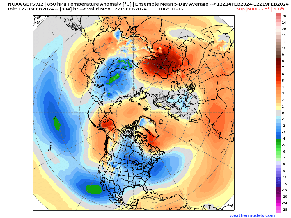
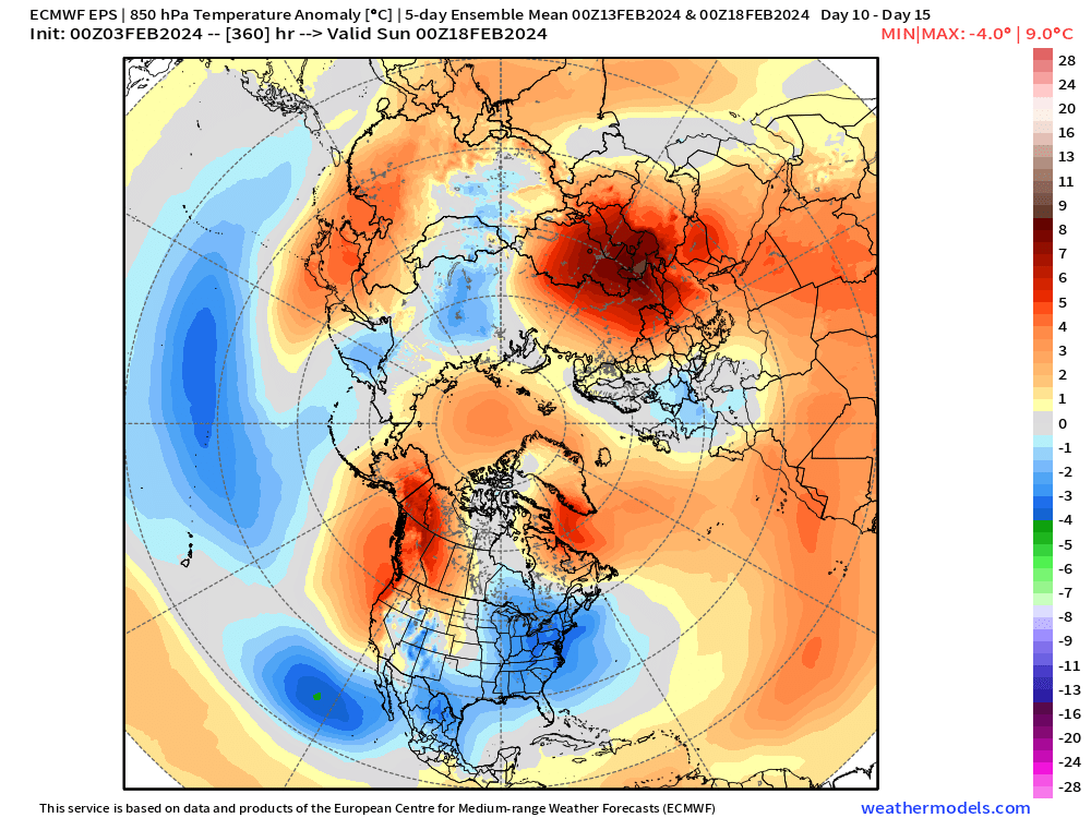
Also noting some divergence in the EPS and GEFS out at the end of their runs....GEFS is trying to really push a very strong low into the GOA....Euro keeps it weaker and a bit further west....e.g., GEFS has a rapidly deteriorating PAC while the EPS does not. Both have a potent -NAO/AO though....which would be quite beneficial in the event of a deteriorating PAC, but a more hostile PAC starts to leave you with less wiggle room. Good news is that EPS led the GEFS for the mid-month switch, so hopefully they are more correct. We're also dealing with a potential SSW around the ides....if that happens, it could affect early March. -
It was a Flop... February 2024 Disco. Thread
ORH_wxman replied to Prismshine Productions's topic in New England
Interior elevations....airmass is marginal and system looks weak. I guess if we make it a more potent system, it could get more interesting. -
It was a Flop... February 2024 Disco. Thread
ORH_wxman replied to Prismshine Productions's topic in New England
The 2/13 threat is prior to good airmass advecting in…i mentioned this a couple days ago. Not a system of interest outside the interior elevated areas. -
It was a Flop... February 2024 Disco. Thread
ORH_wxman replied to Prismshine Productions's topic in New England
I got snow cover in my front yard while across the street is grass. Spring snow pack pattern. -
It was a Flop... February 2024 Disco. Thread
ORH_wxman replied to Prismshine Productions's topic in New England
Yeah your area hasn’t been bad at all. December was a tire fire but you’ve had pack since 1/7 and around 30” in January. -
It was a Flop... February 2024 Disco. Thread
ORH_wxman replied to Prismshine Productions's topic in New England
Interior NW of 495 doesn’t qualify as ratter imho right now. Maybe way NW line Mitch to Hippyvalley has been ratter territory. But ORH to Ray 495 belt and back to Monads has been ok…subpar but not too awful. December being a disaster brings it down a peg though. -
It was a Flop... February 2024 Disco. Thread
ORH_wxman replied to Prismshine Productions's topic in New England
‘55-56 is a good example. -
It was a Flop... February 2024 Disco. Thread
ORH_wxman replied to Prismshine Productions's topic in New England
Yeah me too. That western ridge isn’t that far east. In addition, you can see later in the period how the Aleutian low is starting to migrate east and trying to become a GOA low. That will also start making things more precarious the further south you are. Now maybe the NAO offsets it enough or the Aleutian low never makes it far enough east to beat down the western ridge (weeklies sort of reload it further west in late February/early Mar), but I’d always be leery of things that can push the goods further north because that has been a recurring theme. -
It was a Flop... February 2024 Disco. Thread
ORH_wxman replied to Prismshine Productions's topic in New England
That system is an uphill battle imho. It’s prior to advecting in a decent airmass so it’s gonna have to thread the needle (surprise!)…guidance currently progressively gets more favorable beyond that timeframe. -
It was a Flop... February 2024 Disco. Thread
ORH_wxman replied to Prismshine Productions's topic in New England
It’s snowman19’s passive-aggressive way of trying to downplay any potential in the pattern for mid-February and beyond. Ray sniffed out his M.O. pretty well. I’ll personally be watching shortwaves dive out of Canada and anything southern stream…others can worry about dips and peaks in Nino 3.4 in February if they want. -
It was a Flop... February 2024 Disco. Thread
ORH_wxman replied to Prismshine Productions's topic in New England
-
It was a Flop... February 2024 Disco. Thread
ORH_wxman replied to Prismshine Productions's topic in New England
The Atlantic blocking has been getting stronger as we go deeper into February on ensembles. I just hope the PAC doesn’t go hostile after 10 days…even if it just goes to neutral after 10 days, a strong -AO would work fine (ala Feb 2021)…but hopefully both remain favorable for longer. -
It was a Flop... February 2024 Disco. Thread
ORH_wxman replied to Prismshine Productions's topic in New England
I think there was a major controversy at BWI for that storm. They were clearing every hour or something like that. Same thing happened at BOS too…BOS real total was prob more like 23” instead of the “record” 27.6”. -
It was a Flop... February 2024 Disco. Thread
ORH_wxman replied to Prismshine Productions's topic in New England
Ray’s favorite storm. Id take it though. Over 20” in ORH and that extended right down into the 495 belt here. -
It was a Flop... February 2024 Disco. Thread
ORH_wxman replied to Prismshine Productions's topic in New England
Could end up dry for second half of February but it also might not. It’s a split flow pattern out west. -
It was a Flop... February 2024 Disco. Thread
ORH_wxman replied to Prismshine Productions's topic in New England
Stratosphere is getting interesting on guidance too. Some support showing up for another big SSW like last year in Mid-Feb (this helped set the stage for the first couple weeks of March last year where he had several threats including the interior elevation bomb on Mar 13-14. ) The difference this year is that if we get another SSW like last year, we won’t be fighting nearly as hostile as a Pacific and the AO already looks to be negative. So it just may lock things in place longer which is what you’d hope for if you want more than a short period of favorability. We’ll know a lot more about the SSW chances in the next 5-7 days. -
It was a Flop... February 2024 Disco. Thread
ORH_wxman replied to Prismshine Productions's topic in New England
It’s a fair criticism. I don’t trust them either until inside of D10. But at least they aren’t can-kicking and there’s pretty strong signals on them. If they continue to look good by Sunday/Monday, then I’d feel a lot more optimistic.

