ORH_wxman
-
Posts
93,099 -
Joined
-
Last visited
Content Type
Profiles
Blogs
Forums
American Weather
Media Demo
Store
Gallery
Everything posted by ORH_wxman
-
ARW should do it sometime between now and 15z run tomorrow
-
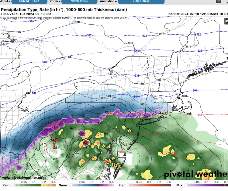
Much less impressive aloft that run but that’s gonna happen. It’s why we’re not forecasting 1-2 feet. But I think the general idea of a favorable track puts a floor of about 7-8” there. Exact dynamic evolution still TBD which will determine whether it’s 8-10” or 12-18” in your area.
-
Yeah agreed and I’m not even really counting a few drops at the onset for a place like HFD down to MMK before they wetbulb…when the real precip gets going, it’s going to be snow unless we see some drastic change in guidance over the next 24-36h.
-
Don’t think so
-
On what model? The ICON?
-
No, euro actually draws in pretty cold air on that type of solution. I don’t think you’re going to have any paste at all save maybe the first 2-3 hours when rates are not heavy yet.
-
ICON starting to sober up too. Came south a good tick but still north of other models.
-
18z Reggie bumped solidly N too. Still decently south of Euro/GFS but it gets warning snows up to near the pike or just S.
-
If you can crank 1”+ of QPF then you’re good for at least 8” of snow imho. Look at how shallow the near-freezing layer is at the sfc. Unless this zonks another 50 miles north, I’d feel ok on eastern coast near BOS and immediate south shore. It’s not like one of those thermal profiles where it’s 0C to -1C for hours at 925mb and you’re hoping to tick it another 1C colder. It arrogantly goes to like -3 pretty quickly.
-
NAM starting to figure it out. Still south but not total fringe jobs like 06z/12z.
-
Euro was spitting out 1.4-1.7” of QPF over a chunk of central/eastern MA…so ratios really don’t need to be crazy to get 18”+ on that. Is it right? Meh, prob overdone but it’s within the envelope of possibilities given go w dynamic the Euro was aloft.
-
There’s no worry where you are. But HFD and south needs to watch closely.
-
Yeah tossing the mesos until we’re another 24 hours closer.
-
Surprised you are bearish on the snow threat.
-
NAM was def north early on but it kind of ended up similar to 06z. Still in clown range for that model though.
-
NAM will be north of the 06z run but that isn’t surprising considering how flat 06z was
-
I’d be pretty surprised if there wasn’t a decent stripe of 10-14” but it won’t be for everyone.
-
It’s prob from first flakes to last flakes it might be 12-15 hours but for stuff that actually is going to accumulate it’s prob like 9 hours.
-
Yeah and if you’re getting huge omega in that band, I’m thinking someone it gonna go 15 or 18 to 1 on ratios for a chunk of it. So I think that needs to be kept in mind….a little early to obsess over soundings, but sometimes you’ll see people say “what a model bust” if they get a 17” fluff bomb but they ended up with like an inch of QPF just like guidance was saying. On the flip side, you’ll see it too if they go 7 to 1 ratios but the QPF was still accurate.
-
There’s still like 3 days for figure QPF but I think someone in a band will do really well with this bumping up against the confluence. Where it’s cold over the interior, you’re gonna have to watch ratios too if we get a crosshair sig…someone could get a foot from like 0.80” of QPF if they’re going 15 to 1.
-
Coastal areas might be more like 5-8”.
-
May need to watch for a CF…esp during the first half of the event.
-
GGEM still kind of clueless but not as much as 12z. At least it gets measurable snow to the pike this run.