ORH_wxman
-
Posts
93,099 -
Joined
-
Last visited
Content Type
Profiles
Blogs
Forums
American Weather
Media Demo
Store
Gallery
Everything posted by ORH_wxman
-
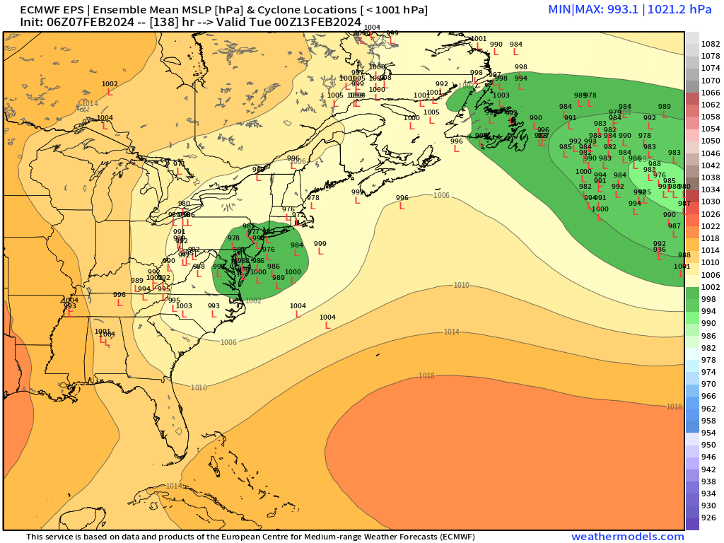
GFS does get crunched a bit at the last second to keep it a big paste job N of pike and inland but if that goes further north, it’s almost an inland runner.
-
GFS is gonna be warm and zonked.
-
Icon doesn’t phase but it’s still a hugger. Big hit for CNE. SNE does get some snow but not warning snow until you’re north of the pike.
-
The icon is just fundamentally different than other guidance outside of the Ukie. It completely separates the northern and southern streams. Only ICON and 00z Ukie are doing this. It’s a plausible solution but you’d want to see more support for it.
-
Can’t keep them down for long. 12z ICON coming out slow today.
-
I don’t really follow the ICON that much. Its a bit noisy for my liking. I treat it like the other JV models. It’s prob better than the NAVGEM and JMA and those types, but I’d never weight it more than the GGEM or Ukie. It mostly has any use at all because it comes out early so sometimes we can get a better sense of what the gee tal model trends will be on that particular cycle.
-
It was a Flop... February 2024 Disco. Thread
ORH_wxman replied to Prismshine Productions's topic in New England
Yeah agreed. Faster means we’re getting better phasing with the initial northern stream shortwave which produces those northwest scenarios. We even had a run or two of a pure cutter on the GGEM a couple days ago. Slower means less phasing or at least more delayed phasing even if it’s partial and a further south solution. -
It was a Flop... February 2024 Disco. Thread
ORH_wxman replied to Prismshine Productions's topic in New England
Yesterday most people were thinking it would get crunched SE. Now a whole bunch of people yelling congrats to dendrite and powderfreak. Lot of minds on tilt these days. It could honestly go either direction. -
It was a Flop... February 2024 Disco. Thread
ORH_wxman replied to Prismshine Productions's topic in New England
Yep. Not a good way to look at it yet. A bunch of people would be crushed if we could see another 12 hours. -
It was a Flop... February 2024 Disco. Thread
ORH_wxman replied to Prismshine Productions's topic in New England
Maybe. It’s an unmanned firehose look though. There’s literally huge solutions for almost anyone in New England. 2/13 is mostly gravy imho anyway never expected much out of this but it has a legit chance. -
It was a Flop... February 2024 Disco. Thread
ORH_wxman replied to Prismshine Productions's topic in New England
06z eps has a solution for everyone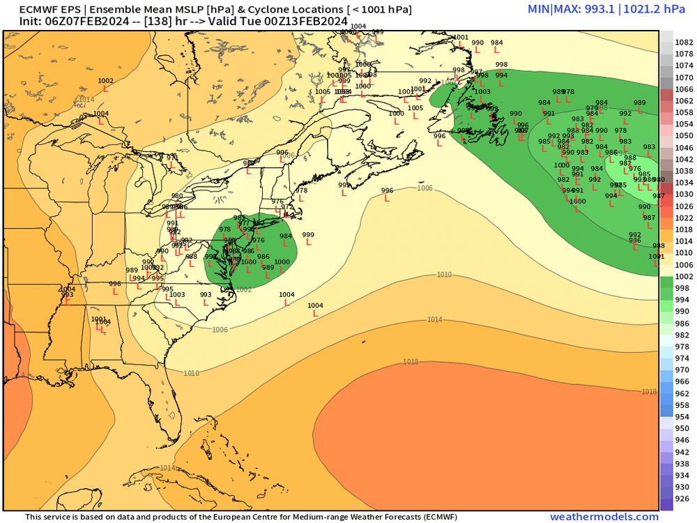
-
It was a Flop... February 2024 Disco. Thread
ORH_wxman replied to Prismshine Productions's topic in New England
They retrograde the GOA/Aleutian low nicely and go strong -AO/-NAO in pulses which is nice too see. @Typhoon Tip likes to see it oscillate a bit on magnitude since that is where storminess is most likely. -
It was a Flop... February 2024 Disco. Thread
ORH_wxman replied to Prismshine Productions's topic in New England
A nice aspect of todays ensemble runs (both GEFS and EPS) is we’re seeing the GOA low retrograding back west at the end of the run. This is something @brooklynwx99 and I were pondering the last couple days. He had mentioned that it should theoretically retreat given the PAC jet weakening. It’s good to see guidance trying to pick up on that. A window longer than 7-10 days would substantially increase the chances of hitting on a major storm threat. -
It was a Flop... February 2024 Disco. Thread
ORH_wxman replied to Prismshine Productions's topic in New England
Not at all. Solutions all over the map including some huge hits. -
It was a Flop... February 2024 Disco. Thread
ORH_wxman replied to Prismshine Productions's topic in New England
Aside from the 2/13 threat which is precarious, I do really like the look afterwards in the 2/15-2/20 range. Really poleward ridge with cold antecedent airmass over much of the eastern half of the country. Good setup for something higher end. -
It was a Flop... February 2024 Disco. Thread
ORH_wxman replied to Prismshine Productions's topic in New England
Yeah that’s squashed. Ridge axis is decently west though so certainly room for it to improve. Gonna either need more phasing with northern stream or more lagging. This run was the sweet spot to basically crush the whole thing south. -
It was a Flop... February 2024 Disco. Thread
ORH_wxman replied to Prismshine Productions's topic in New England
Yeah but it prob had a moisture feed from further south once the storm started developing a legit warm conveyor. -
It was a Flop... February 2024 Disco. Thread
ORH_wxman replied to Prismshine Productions's topic in New England
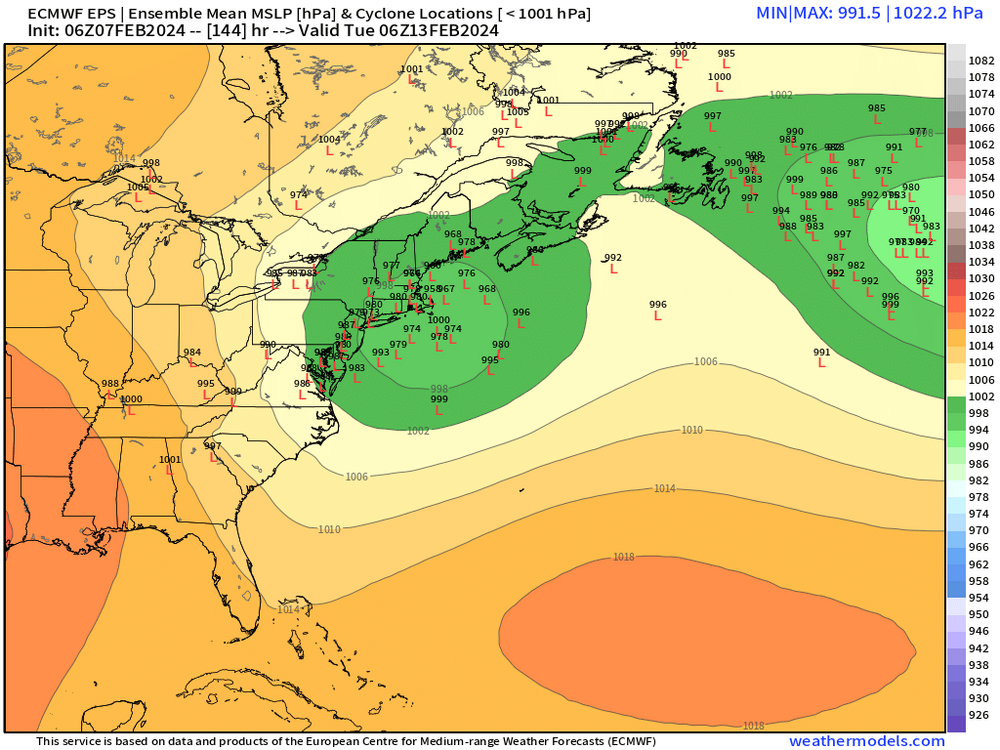
Southern stream is def lagging northern stream so far on this euro run at 120h -
It was a Flop... February 2024 Disco. Thread
ORH_wxman replied to Prismshine Productions's topic in New England
Yeah you can get close, but you never see like a 45-50” total from any of those 18-24 hour storms. It’s always a stalled monster like ‘78, or 1888 or Feb ‘69 or Dec 1992 (higher terrain). That’s why I mentioned to Ray that the “cap” on a shorter duration storm seems to be in that 3 foot range. -
It was a Flop... February 2024 Disco. Thread
ORH_wxman replied to Prismshine Productions's topic in New England
Agreed for the most part but he’s correct if you’re looking to go super high end. How many storms over 3 feet are less than 24 hours? Almost none of them. Sure, even blizzard of ‘78 or Feb ‘69 had most of the snow fall in a 24 hour period but those 40”+ totals are prob like 28-35” if it doesn’t keep going and going. Same deal with those 40+ burgers in Mar 2001. Even in an occluded state, if you have spokes of energy rotating around a pseudo-stalled ULL, it can reinvigorate the snow bands…even if not to their peak intensity…which helps add on those additional accumulations that would otherwise hit the 3-foot wall that we often see in other high-end storms that lack duration over 24-30 hours. -
It was a Flop... February 2024 Disco. Thread
ORH_wxman replied to Prismshine Productions's topic in New England
Ukie only goes out to 144 on freebie maps but it looks more like the phased solution of northern and southern streams. Prob ptype issues on that look. -
It was a Flop... February 2024 Disco. Thread
ORH_wxman replied to Prismshine Productions's topic in New England
Yep I would like to see that second northern stream s/w dive in and phase after the initial northern streamer s/w outruns the southern s/w. Certainly a good background pattern to trend a sharper northern stream with the building western ridge. We’ll see how it plays out. Canadian is trying to force the first northern stream shortwave to be the main show with the southern stream lagging behind a bit but not enough to ruin the storm. Verbatim a nice hit on GGEM but an unstable solution. -
It was a Flop... February 2024 Disco. Thread
ORH_wxman replied to Prismshine Productions's topic in New England
Wide right on GFS. But honestly not a terrible spot for 7 days out. There’s a lot of ways to get that further north. -
It was a Flop... February 2024 Disco. Thread
ORH_wxman replied to Prismshine Productions's topic in New England
ICON wants to play ball but more for 2/14 rather than 2/12-13. It lags the southern stream behind and let’s northern stream outrun it and then amplifies the southern stream into the main event. That’s a pretty good look because it creates a better antecedent airmass out ahead of the storm. We’ll see what the real models say in a bit. -
It was a Flop... February 2024 Disco. Thread
ORH_wxman replied to Prismshine Productions's topic in New England
I’m in Quincy today and could see the line of clouds just to the west when I left home but then everything got thicker and thicker overcast as I went east. Pretty cool to see.