ORH_wxman
-
Posts
93,099 -
Joined
-
Last visited
Content Type
Profiles
Blogs
Forums
American Weather
Media Demo
Store
Gallery
Everything posted by ORH_wxman
-
It was a Flop... February 2024 Disco. Thread
ORH_wxman replied to Prismshine Productions's topic in New England
I’m intrigued by that Feb 17-18 period. All guidance has a pretty broad southern stream wave…question is whether we can amplify it into the PV lobe over S E Canada. -
I don’t mind it being south at the moment.
-
Everything south at 12z except ICON.
-
Man, GGEM barely gets much up here either....CT/RI special. How about a 70/30 compromise in favor of EPS?
-
North of 00z by a tick....didn't matter...potent southern streamers find ways to amp up frequently.
-
I'm considering anything from this storm pure gravy. Would be nice to score on a marginal setup, but it's never looked like anything other than marginal even on the good runs.
-
It was a Flop... February 2024 Disco. Thread
ORH_wxman replied to Prismshine Productions's topic in New England
Too bullish in MA -
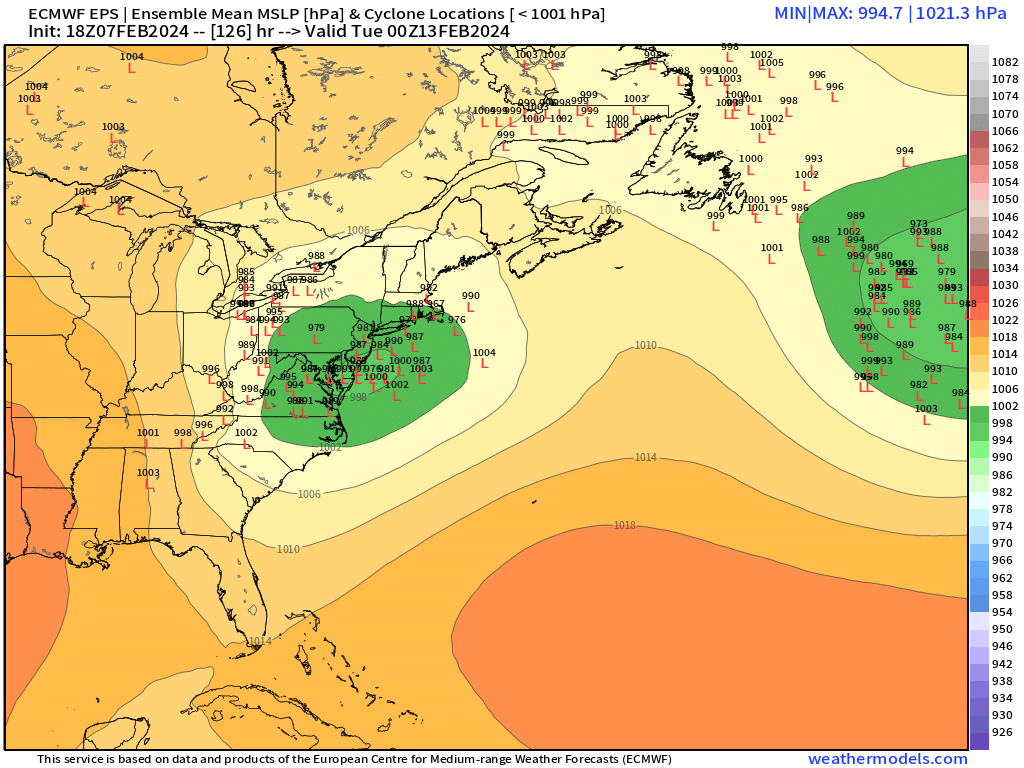
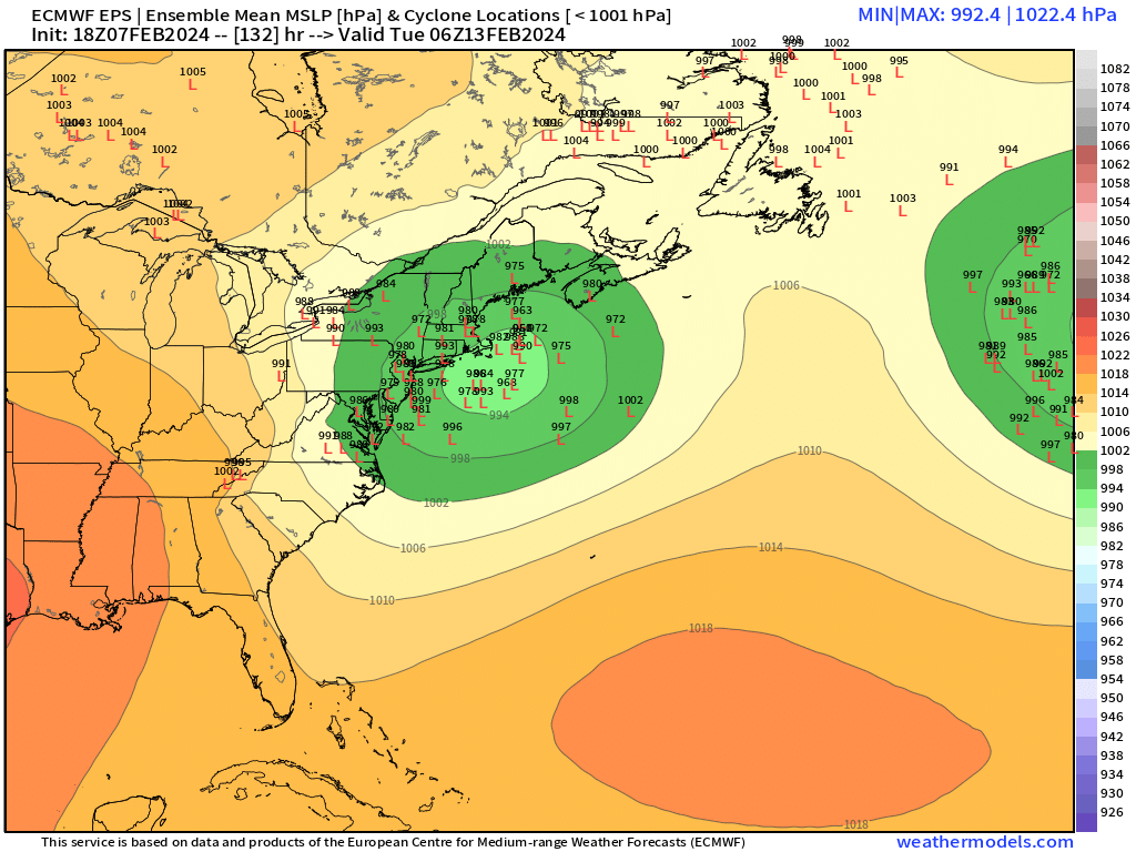
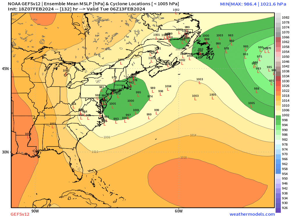
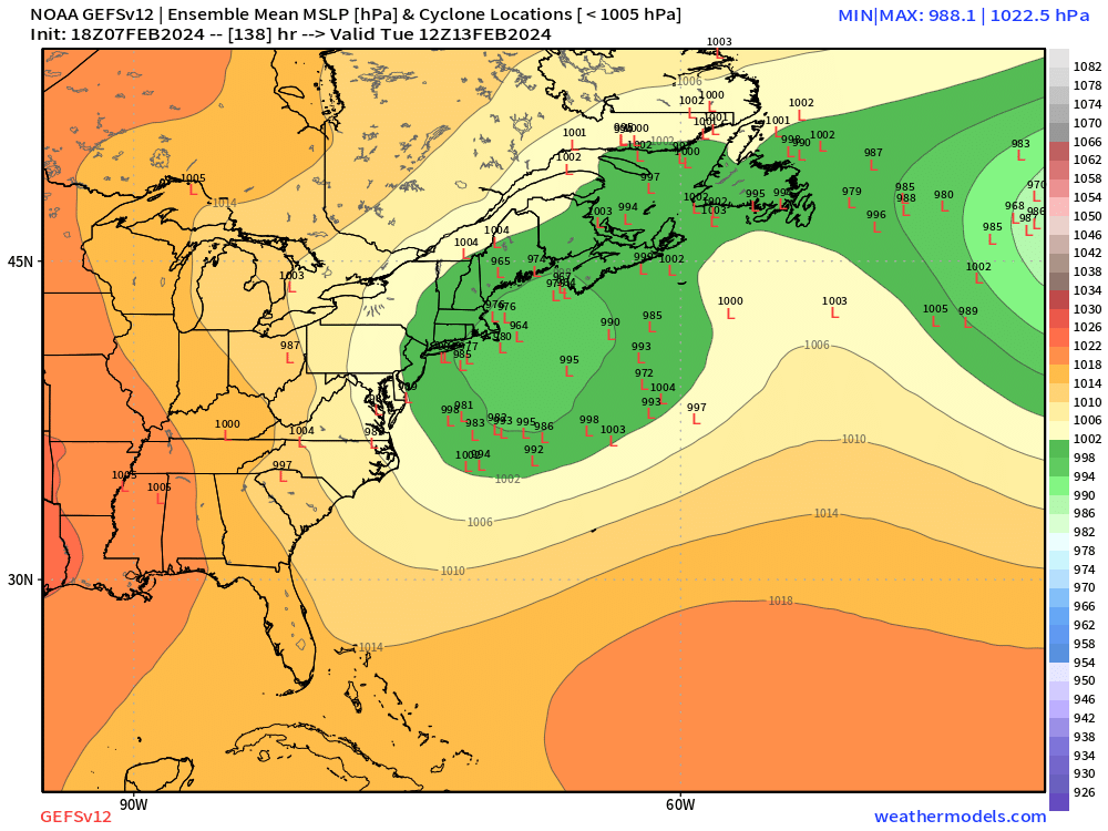
So GFS/GEFS are a whiff/near-whiff while the 06z EPS is ripping the low into LI. Glad to see we've cleared up everything.
-
It was a Flop... February 2024 Disco. Thread
ORH_wxman replied to Prismshine Productions's topic in New England
Yeah agreed. I was thinking our first big shot was Feb 16-18 range but there’s definitely another window there after 2/20. I like seeing the block north of AK too because it keeps the source region pretty cold. That helps in avoiding a totally rotted airmass with the -NAO. We had that problem in late Feb/early Mar 2010. -
18z eps came SE a solid tick. Still a lot of time for this one to keep shifting


-
It was a Flop... February 2024 Disco. Thread
ORH_wxman replied to Prismshine Productions's topic in New England
I think that storm was on Veterans Day so they already had the day off and it ended predawn on the 12th. A lot of snow fell during the night of the 11th and predawn the 12th but then it was out the door. -
18z GEFS still has a decent spread but there’s a surprising number of members that never get the storm to our latitude
-
Tons of preemptive cope and reverse psychology. We know the drill by now. I’ll ask people to keep this thread cleaner though. Keep the focus on this system and not personal depression on how this winter is going. Everyone already knows how bad it’s been south of the pike.
-
More threads are better. Super threads honestly suck because you have to Wade through so much crap sometimes. This thread is completely fine. Unless you were under the delusion that it was going to be all snow in your backyard, it’s a thread that is seeing increased support for some sort of system. There are likely to be plenty of people on this forum who see good snow from this. It happens to favor CNE/NNE right now…which is what the antecedent airmass has suggested for quite some time. For SNE outside of the higher terrain north of the pike, it’s always been a thread the needle system for big snow.
-
Yeah but most expected winter to suck in December during a potent El Niño. We need a scapegoat for Jan/Feb when El Niños typically go gangbusters.
-
Yeah I’ve never liked this threat for our area…posted days ago I didn’t like the airmass….eps still has plenty of decent members but the mean is def headed north and it makes some sense if we’re not getting a good area of confluence in Quebec. We need to time everything nearly perfectly to get something big.
-
EPS looks like crap until you get up around dendrite
-
Yep. You aren’t getting double digit worthy QPF from that look. Not much dynamics either. Im not very optimistic for SNE in this system, but it’s not because of a euro solution. Euro is one a million different versions that can end in not much.
-
It’s a very sheared shortwave. Almost certainly won’t end up verifying because it’s a razors edge solution where it’s in the perfect spot not to amplify into anything more substantial.
-
Ukie stops at 144 on the freebies but it has a lot of similarities to the GFS.
-
I don’t have a lot of hope for this system in SNE mostly because of the marginal antecedent airmass (been saying this for days about 2/13), but there’s some sneaky upside if we’re able to thread the needle…very dynamic look.
-
The best PVA and energy on these 12z solutions is at the base of the southern stream trough so even on these solutions that initially run things well NW, they keep trying to crash everything SE as the system encounters a lot of compression in the flow to the east. GGEM went wild too late in the event after having the primary near ROC, though it was mostly too late for SNE outside of a few inches in the pike region northeastward….but Maine gets epically destroyed. Lol
-
The snowfall distribution is kind of similar but the evolution is definitely not.
-
25-burger for Ray on the GFS