

ORH_wxman
-
Posts
93,099 -
Joined
-
Last visited
Content Type
Profiles
Blogs
Forums
American Weather
Media Demo
Store
Gallery
Everything posted by ORH_wxman
-
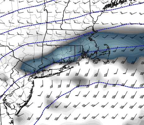
Funny how the Reggie QPF is so paltry again outside of SE MA but the H7 fronto is in the roughly same spot as NAM
-
ICON is south of 06z....though the 06z ICON was easily the furthest north model. The 12z ICON is going to look a lot like the 12z NAM
-
NAM was pretty much there...you'd prob get the northern part of the good banding
-
Agreed....QPF is very useful, though even that can be iffy at times, but QPF is an order of magnitude better than snow maps. When it comes to coastals, give me some good Mid-level maps with fronto and a few soundings....the QPF map can then be used with those other variables to get a more accurate picture of the potential snowfall.
-
Going to be a sharp cutoff....I don't think it goes from like 10-12" to 2" in 10 miles....but it could go from 12" to about 5-6" in 15-20 miles.
-
You don't want that bumped more....best banding is typically just N of H7 fronto
-
I've become more and more disillusioned with clown maps...they are lazy and often too wrong...looking at mid-levels and soundings is way better.
-
This is poundtown look at H7
-
Def a good bump N of 06z through 24h.
-
12z NAM so far seems to have more northern stream interaction through 18h vs 06z....so we'll see if this bumps back a touch NW with the precip shield.
-
It was a Flop... February 2024 Disco. Thread
ORH_wxman replied to Prismshine Productions's topic in New England
Alright man....see you in April then. -
Eastern coastline....it's fine back west.
-
It was a Flop... February 2024 Disco. Thread
ORH_wxman replied to Prismshine Productions's topic in New England
Clipper for Thu night has been coming back stronger the last 24h. -
Tossed. Southern outlier now.
-
Can’t rule it out. You prob want to see a little tick back north to feel safe there.
-
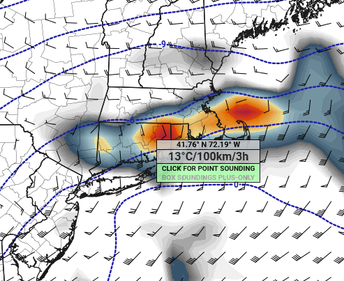
Midlevels look very good for that corridor. But prior to going to bed last night I had mentioned a steep cutoff in precip and that’s still showing up this morning so im thinking it’s real. I think less northern stream interaction is helping increase the gradient. Someone is going to get absolutely smoked though on the northern side where the fronto band sets up.
-
There definitely seems to be not only a southward trend, but the precip cutoff is becoming tighter. You might go from a foot to 2” in a span of 15 miles if these solutions are correct. Something we’ll have to watch for on the next couple cycles…if that very tight gradient persists.
-
You are correct with this for most of the SNE forum members and a chunk of the southern CNE members. Coast still has some legit concerns though…esp like cape over to SE CT coast.
-
Clown maps are prob going to be woefully overdone on the southern 20% of their coverage.
-
That was actually a really nice run for your ‘hood looking at H7.
-
When I was toggling h5 at 42h, it was def a tick north. I don’t toggle QPF maps when I’m doing my analysis
-
Euro looks a touch more amped at 42h?
-
Yeah there’s still another full day of model guidance to tickle back north. Even right now, the midlevels aren’t bad for S NH…maybe not jackpot but pretty good
-
They used to a long time ago before that. I am pretty sure that old criteria was sub-20F.


