

ORH_wxman
-
Posts
93,031 -
Joined
-
Last visited
Content Type
Profiles
Blogs
Forums
American Weather
Media Demo
Store
Gallery
Everything posted by ORH_wxman
-
Even Canadian is close for you....so anything SE of that is good. But it def has the QPF too
-
We'll see how Euro looks but that is a large increase in QPF for the event
-
GFS is low end warning snowfall for a good chunk of the region.
-
Yeah it looks like it's stuck at 60h
-
Reminds me a bit of this storm....some might remember it http://www.meteo.psu.edu/ewall/NARR/1996/us0302.php
-
21.2" in 1954-55
-
The fact that the two are polar opposites on this storm tells me to ignore the mesos for a bit longer. We'll see what they look like by 00z tonight.
-
Kind of weird how the NAM isn't even remotely interested in this event....Still in clown range for that model though. Showed no interest at 06z either.
-
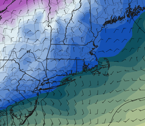
RGEM is def more "Huggy" than others, but still prob snow for most of SNE except far SE....this is 925mb at 84h right before it gets in here....you actually still have weak advection from Maine at this point too
-
Would need to intensify more rapidly…ala 12/29-30/93. That was like a sharper/more intense version of one of the systems with very strong fronto on the cold side.
-
10” of fluff? Don’t think we’re on that train yet.
-
Track in GGEM would jackpot west of us. Prob Hudson valley. I want the sharpness of the GGEM except not having the trough that far west.
-
Get some meat in the snow before the cold shot. Hopefully we can sharpen up the vort one more tick and make this a low end warning event.
-
Definitely very good trends overnight. All major guidance now has solid advisory amounts…just need to hold it now.
-
‘95-96 is such a unicorn…so I hate using that as an example. No previous winter looked anything like it really. Maybe 1898-99…a bit colder but less snow in the northeast (more snow in southeast) Maybe ‘60-61 but not sure if that year hit the southeast good
-
Vort on euro travels right over SNE so there’s plenty of opportunity to bring a nice stripe over the region. The key is don’t let the trough get too rounded which has happened on these 18z runs. Keep it just a smidge sharper and that has nice fronto band written on it.
-
Are they? I think we’d want deeper quantitative analysis to actually know the answer. They kind of seem to be a once per decade type thing…roughly speaking. If we’re including the southeast (and not just mid-Atlantic for the southern extent), then I think it’s probably a safe assumption.
-
Big dog east coast winters are rare anyways. Even historically. The 1980s had some decent mid-Atlantic winters and southeast winters while we got screwed. Most of the good winters in the 1970s were more New England-centric with the huge exception of 1978-79.
-
To be fair, we’re still over 100 hours out. Hopefully things align once we get inside of 4 days. It’s not like we have a ton of variance on the larger scale trough position.
-
We’ll see if that changes as we get closer…sometimes on these fast flow with embedded vortmax events, higher res (OP runs) are gonna pick it up more than ensembles at lower res. I’m not sure if that’s the case here, but I think we’ll have our answer soon enough in the next couple of cycles.
-
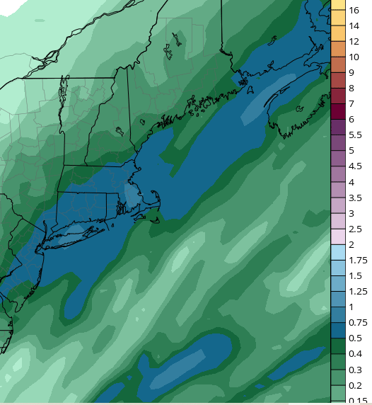
Definite banding sig SE
-
It will oscillate but I don’t think the goal posts are that wide. I expect the canadian to come east. It has no support from other guidance. I’m more worried about a whiff but the 12z GFS moving west to at least getting SE areas is a nice trend.
-
Can’t see QPF yet but Ukie looks pretty far east ala GFS. Canadian may have inherited Uncle’s nip stash after New Years.
-
Yeah those were big fronto bands. They had more vigorous upper level look though. Not quite as fast flow as this one. This one kind of reminds me of that 1/29-30 event in 2018. Was a 1-3” forecast…maybe 2-4” SE areas and this quasi-stationary fronto band with good snow growth set up from like RI to SE MA and got them with a stripe of 6-9”. Big positive bust. People outside the band didn’t have a big bust…it was mostly 1-3/2-4 elsewhere but an area under that band got hit really good. Mostly fell in about 3-4 hours too.
-
Yeah it does. It never goes super slow on guidance like you’d see in a blocky El Niño pattern but the PV lifts north some and the flow relaxes a bit as we get toward the final 7-10 days of the month. That would probably be a potential window for a larger system.


