tiger_deF
-
Posts
615 -
Joined
-
Last visited
Content Type
Profiles
Blogs
Forums
American Weather
Media Demo
Store
Gallery
Everything posted by tiger_deF
-
Even if it was clear sun all weekend for NNE and a monster thumper for SNE, that still doesn't make up for years of the pineapple express of tucked nor'easters bringing heavy snow up North and nothing but wind and rain for us folks in eastern Mass
-
Think of how special the next one you see in person will be! Good things come to those who wait
-

-
If this pans out, and we get a nice coastal bomb in the next few weeks, this will make up for all the crappy winters of the past few years. Yes please!!
-
January 2026 regional war/obs/disco thread
tiger_deF replied to Baroclinic Zone's topic in New England
Ah that makes much more sense! So there's no slick editing team in the background "He's describing the convective potential - scroll a few times to the left or else he'll be pointing at the ocean. Wait, now he's talking about to the warnings in Chelmsford, quick someone get that on stat!" Not anymore... I started lurking here when I was 10, 24 now. Hard to believe it's been over half my life. -
January 2026 regional war/obs/disco thread
tiger_deF replied to Baroclinic Zone's topic in New England
Unfortunately it wasn't a joke. I was aware that it wasn't projected behind them - since otherwise it would project on the presenter - but I had never imagined the visual of someone just standing in front of an entirely blank green canvas whilst pointing and describing things. Especially since it seems so precise that I surmised there must be some kind of visual. Well there's a reason that I'm not a meteorologist despite my love of everything weather related. Here to learn from the best (and occasionally get hyped!) -
January 2026 regional war/obs/disco thread
tiger_deF replied to Baroclinic Zone's topic in New England
I can't believe I never realized that meteorologists were in front of a green screen, and didn't just somehow have the actual weather map visual behind them... somehow I always had the idea that they were seeing what they were pointing to in the background. I'm shook -
January 2026 regional war/obs/disco thread
tiger_deF replied to Baroclinic Zone's topic in New England
It's going to be disappointing if we can't crank a widespread 12"+ out of one of the upcoming candidate systems. We have a persistent, cold airmass in the heart of the season, a ton of moisture with the 24th-26th event, then, according to the GFS, two potential offshore lows that if trends move our way could become quick-hitting nor'easters. Of course I might have just jinxed it with this post but if all goes well we'll be eating for weeks. -
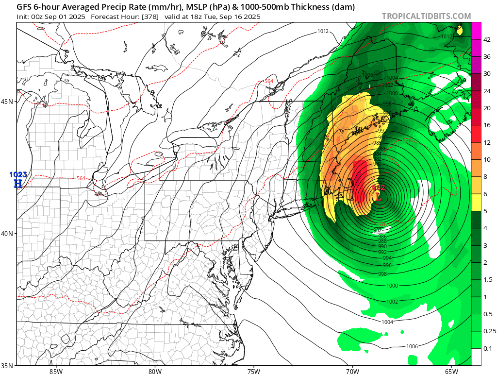
Complete fantasy land but it’s not often you see a model run with a left hook into NE
-
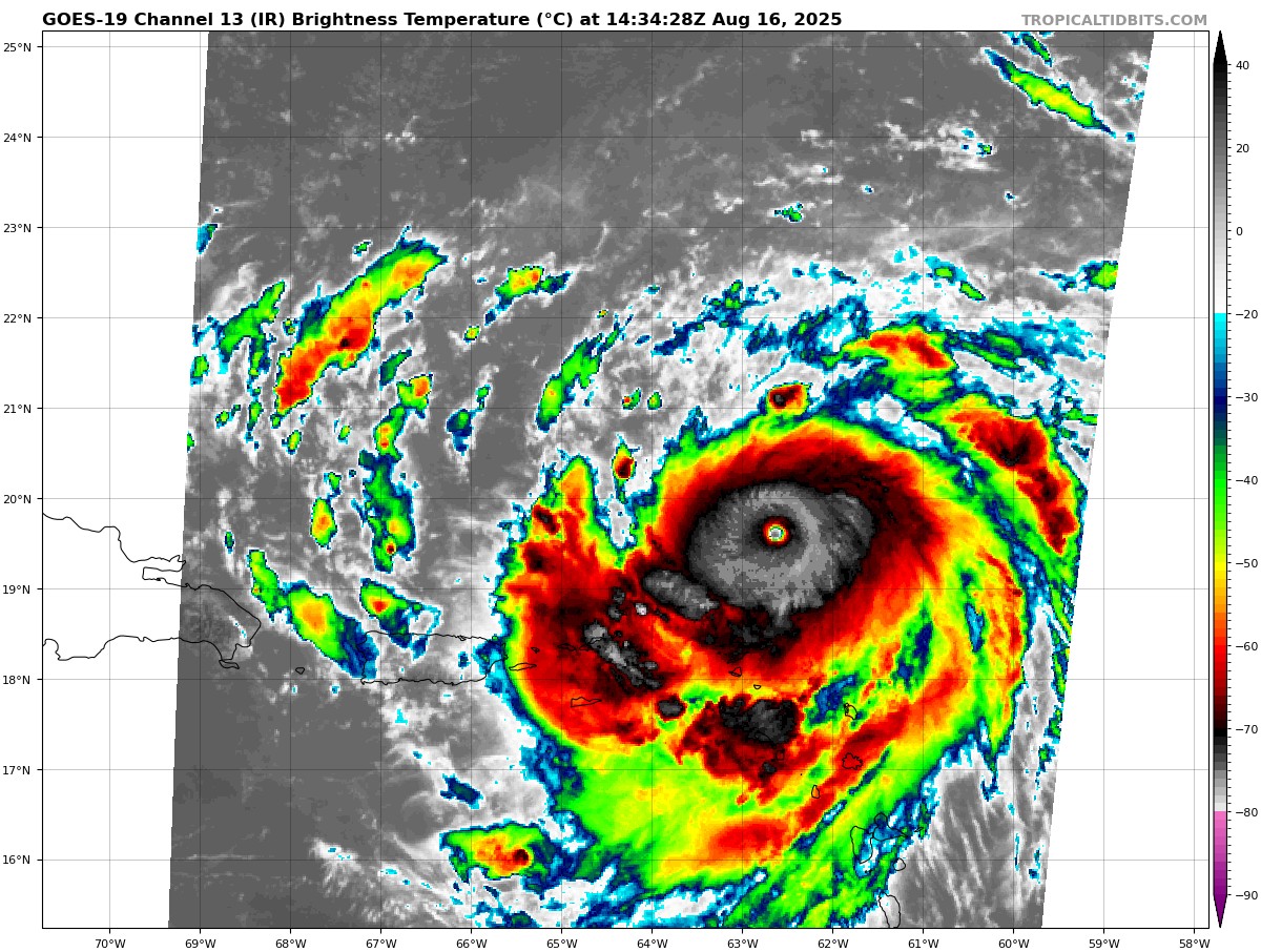
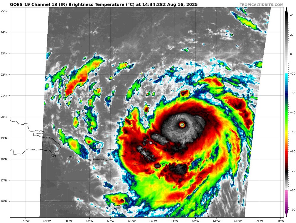
What a beast, cloud tops in the eyewall are still cooling and becoming more symmetrical
-
00z ICON shifts farther west but replaces a high out in the northern Atlantic with a trough, which is not the scenario you’d want to see for even a glancing blow. That being said there’s still a ton of variation with the upper level environment 8 days out. I thought it was an easy recurve a day ago, still the most likely scenario but worth watching for the next couple of days.
-
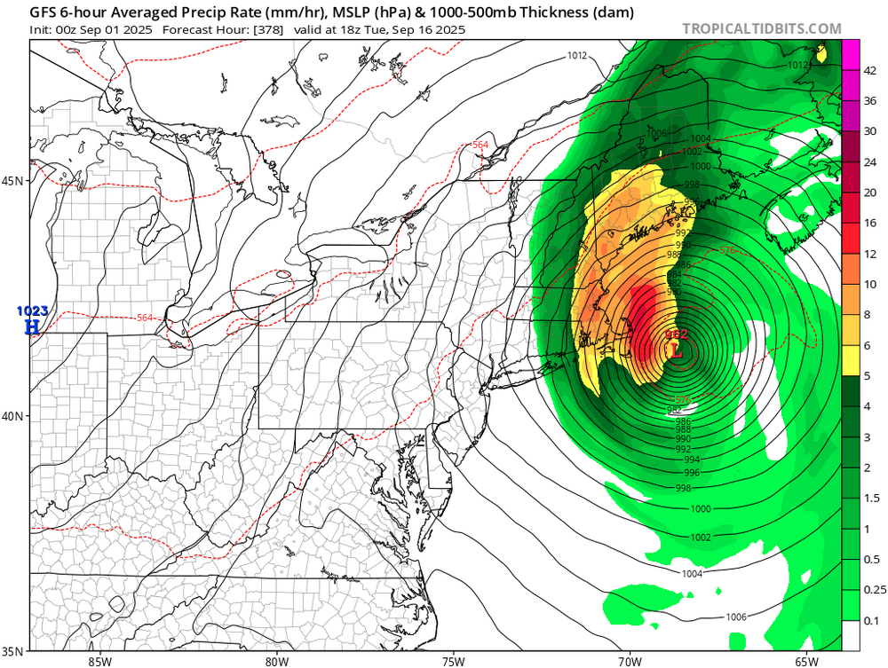
Now that we have a consistent long-range hit, we need to watch for windshield wiping vs serious trends in either direction. If a few runs show it hitting farther down the coast or going OTS, as long as the models keep waffling and shift in the other direction then the hope is alive
-
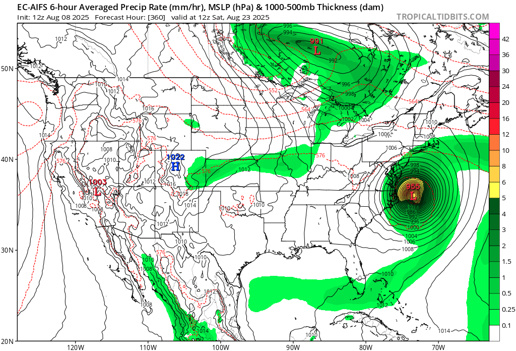
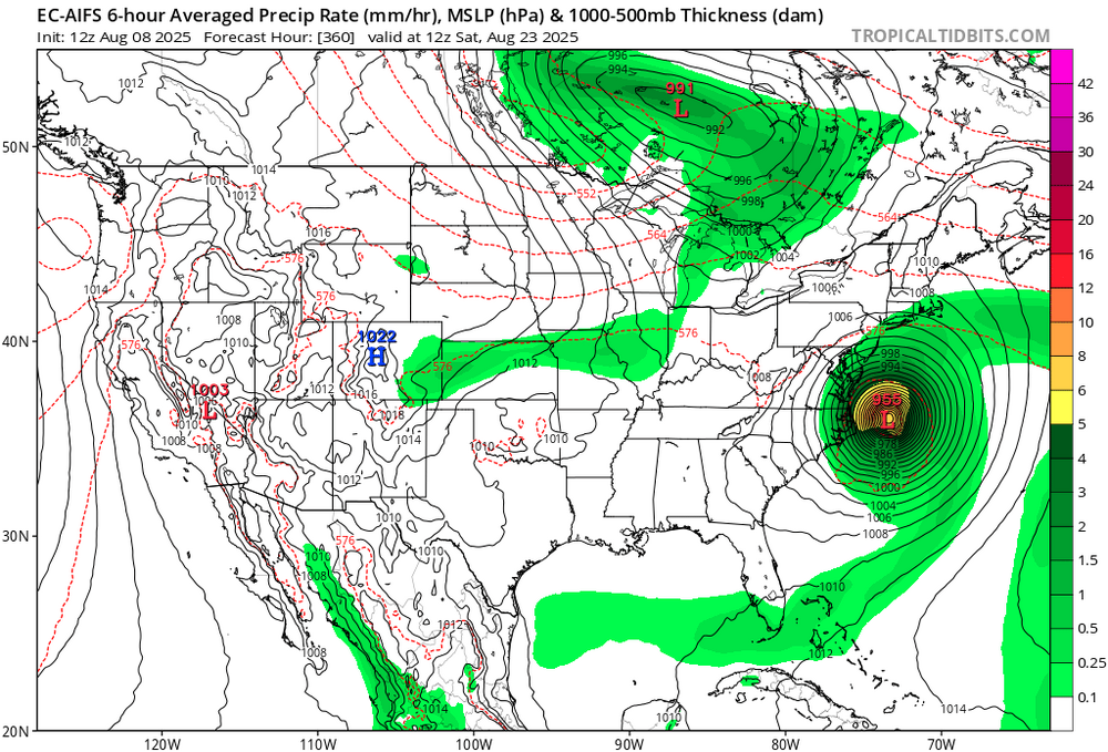
Juicy setup on the EC-AIFS
-
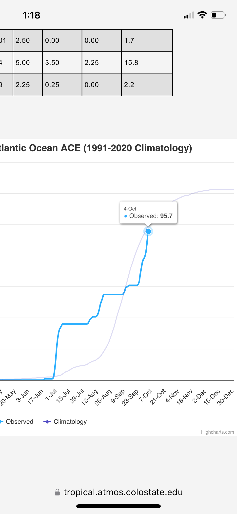
We are extremely overdue, not counting tropical storm meh-nri. Every season we have model runs showing impacts which almost inevitably whiff. I remember Erika, Lee, Isaias, even Joaquin being shown as threats that never ended up materializing. But the historical precedent is there for big hits as unlikely as they are, and the east coast is definitely more at risk this year than the past few gulf-heavy seasons.
-
Given the likely higher than average (though still extremely unlikely) chance of a tropical impact this season, recent interesting model runs, and the tropical clutter in the August disco, I figure it’s time to bring back the tropics megathread!
-
2025 Atlantic Hurricane Season
tiger_deF replied to BarryStantonGBP's topic in Tropical Headquarters
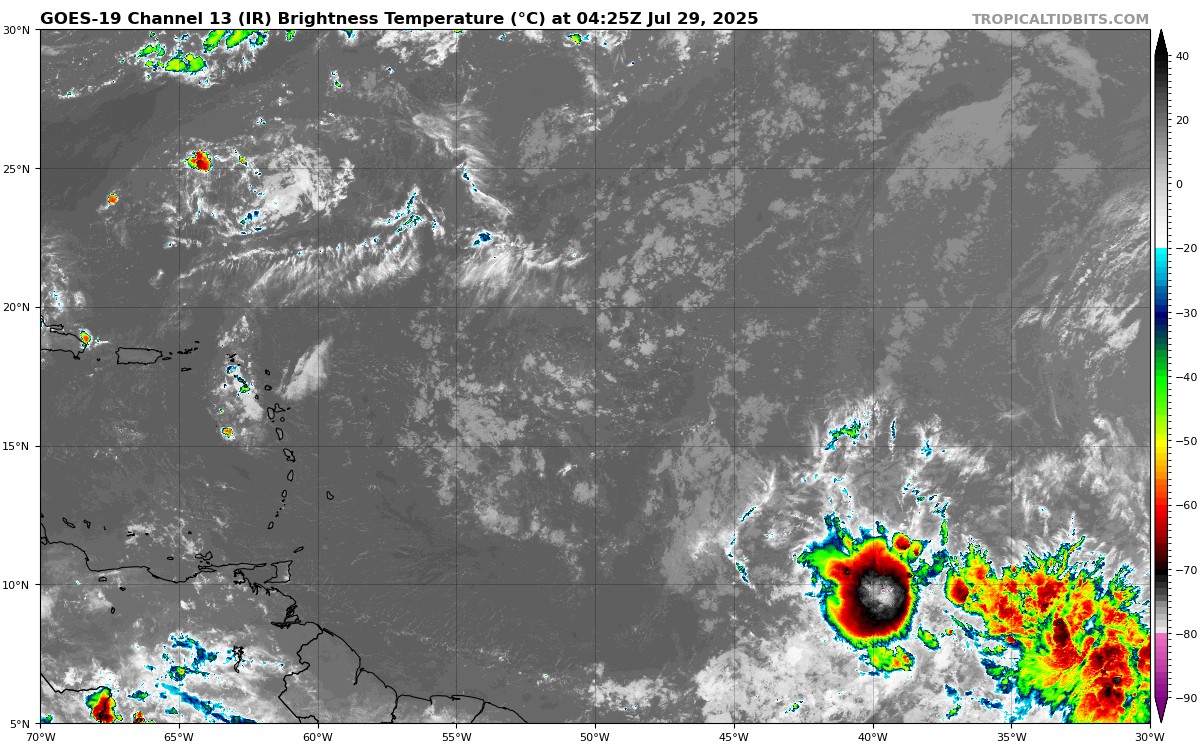
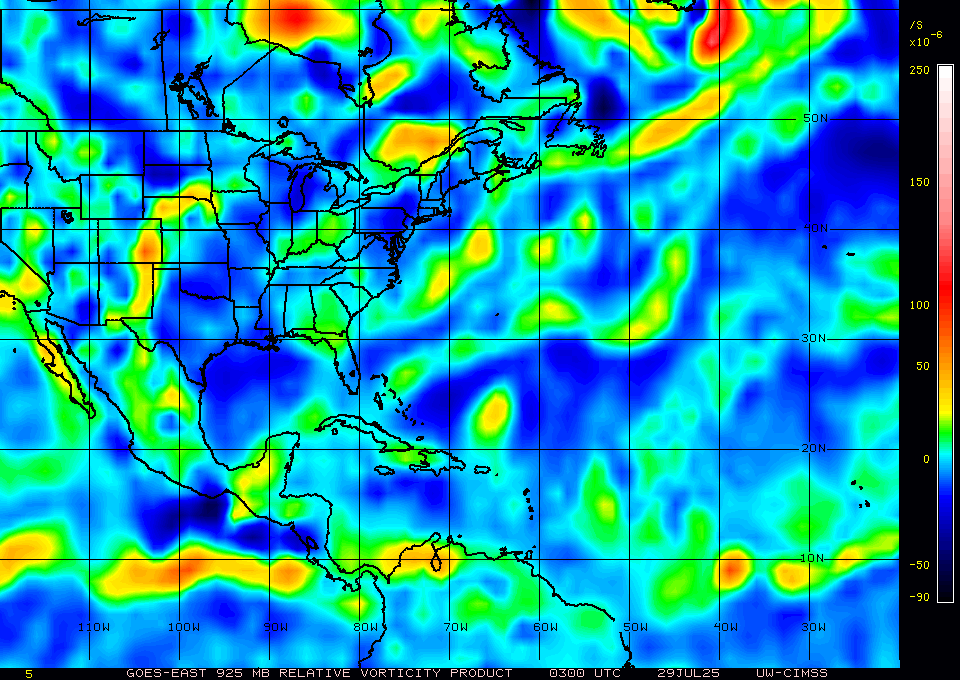
As hostile as the basin state has been for many weeks, the tropical wave at 40W sure is looking good tonight. Lower level vorticity has been increasing dramatically over the past 6 hours and the convection is some of the healthiest I’ve seen in the MDR. Will likely get sheared apart closer to the islands (and the fast background flow will make any consolidation difficult ), but it’s certainly worth keeping an eye on.
-
86/77 in Arlington. Dog is already refusing to finish a full walk.
-
2024 Atlantic Hurricane Season
tiger_deF replied to Stormchaserchuck1's topic in Tropical Headquarters
GFS has been showing development in the western Caribbean for three runs in a row, now in only 6-7 days. Will be the next place to watch. Hoping that nothing develops or that it is more of a gulf threat, since the west coast of Florida will be uniquely vulnerable -
2024 Atlantic Hurricane Season
tiger_deF replied to Stormchaserchuck1's topic in Tropical Headquarters
Leslie has been feeling shy, so of course once model intensities have plummeted and all eyes are off her she has decided to put on a show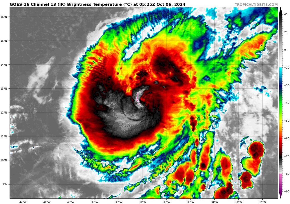
-
2024 Atlantic Hurricane Season
tiger_deF replied to Stormchaserchuck1's topic in Tropical Headquarters
00z GFS sends an even stronger major hurricane into the same area in 12 days, and sends it up the eastern seaboard. Almost certainly not verifying but would be absolutely catastrophic if it did.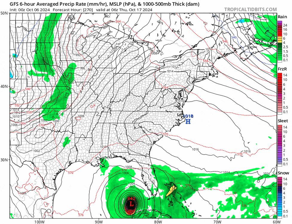
-
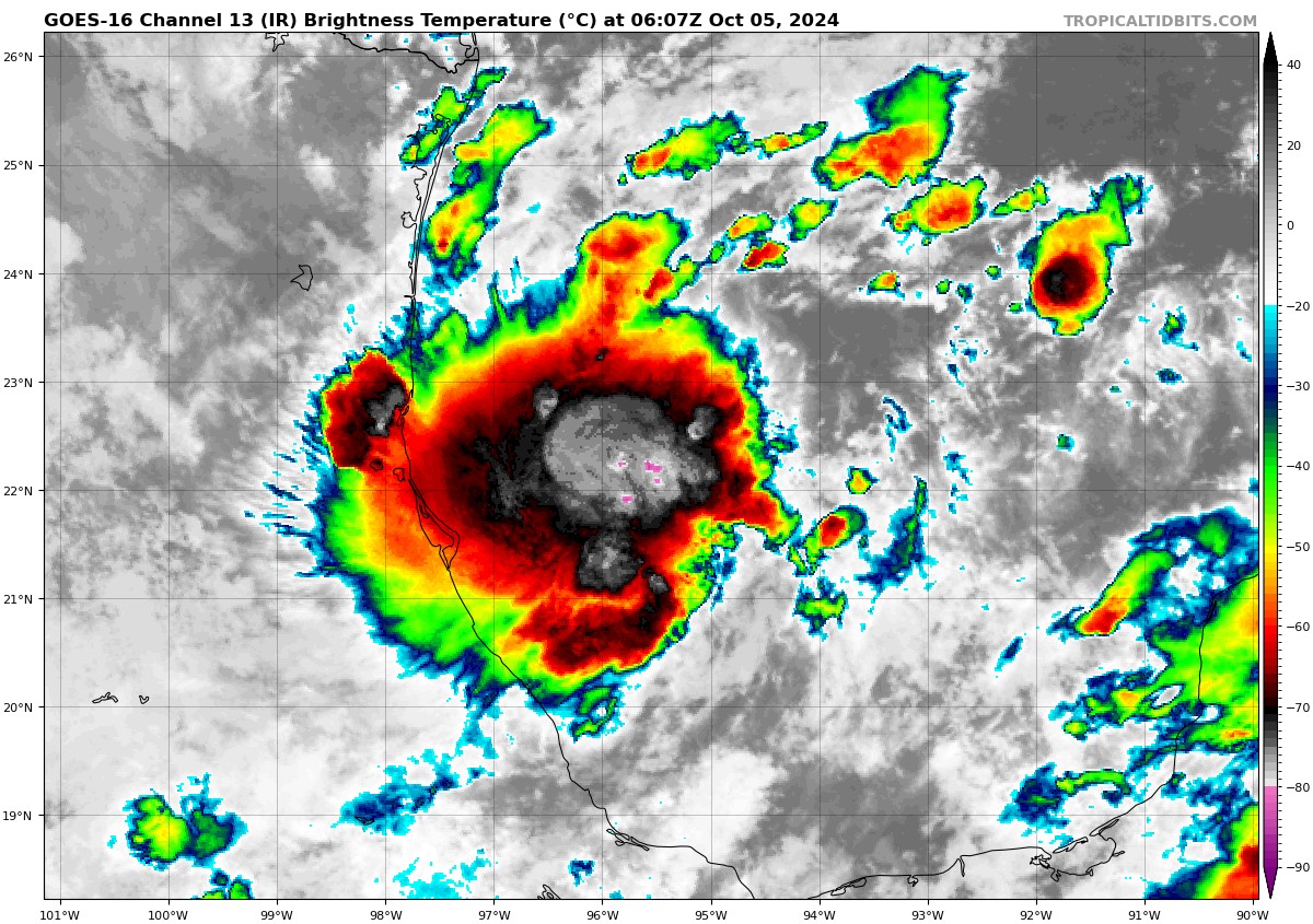
This is quite a rare case of EPAC-ATL crossover, but in the opposite direction! Typically Atlantic systems cross over to the EPAC, but this late season the crossover AOI from the EPAC to the Gulf of Mexico has worked in tandem with CAG-induced instability and vorticity in the region and produced a bonafide low pressure region with intense and persistent confection. I’d still doubt major hurricane status given the northerly shear, but the setup is quite conductive for west to east GOM systems - a rarity even in the past 100 years. Will be interesting to see the evolution of this system, and how it interacts with the punishing high pressure, the trough to the North, and potentially even Leslie if it scoots across the peninsula fast enough.

-
2024 Atlantic Hurricane Season
tiger_deF replied to Stormchaserchuck1's topic in Tropical Headquarters
Crazy season to track. From a cat 5 early July major, to a total shutdown of the basin in peak season, to multiple powerful major hurricanes causing the greatest damage since Katrina during late season. 2024 will be talked about for many decades in the future, not just due to the incredible amount of hurricane landfalls on the gulf coast, but due to the truly anomalous pattern of tropical cyclonegenesis and intensification. Is this another artifact of AGW or just a season with many conflicting signals which have constructively and destructively interfered with each other, or both? Only time will tell.
-
2024 Atlantic Hurricane Season
tiger_deF replied to Stormchaserchuck1's topic in Tropical Headquarters
Keeping my eye on the wave behind soon-to-be Kirk. It would be unprecedented to have a storm form in the East MDR and make it to the islands in October, but the ICON and EC-AI have been showing that as a possible scenario. The future storm is kept locked under a potent ridge that builds just slightly ahead of the disturbance as Kirk moves North. Hard not to buy the early recurve solution but this has been a season of odd behavior. -
The story of this hurricane is going to be the horrifying inland flooding. Entire towns in TN and NC wiped off the map, houses destroyed and the landscape reshaped. Probably dozens of people if not more dead that are unaccounted for. The most impactful hurricane since Ian.