tiger_deF
-
Posts
615 -
Joined
-
Last visited
Content Type
Profiles
Blogs
Forums
American Weather
Media Demo
Store
Gallery
Everything posted by tiger_deF
-
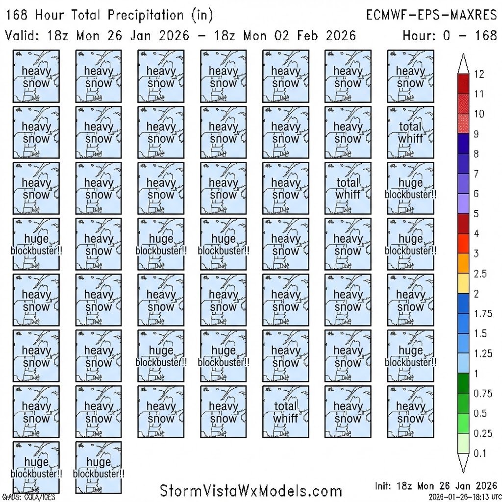
Possible coastal storm centered on Feb 1 2026.
tiger_deF replied to Typhoon Tip's topic in New England
I wouldn’t. I’d be hopping up and down for that amount from a cutter, but if we aren’t getting obliterated from this kind of setup I’d almost rather it be a complete whiff. -
Possible coastal storm centered on Feb 1 2026.
tiger_deF replied to Typhoon Tip's topic in New England
So out of curiosity, what is the difference between a model OP and its ensembles? Does the OP run with more resolution/compute, do the ensemble parameters all vary around a distribution from the OP run? -
Possible coastal storm centered on Feb 1 2026.
tiger_deF replied to Typhoon Tip's topic in New England
It's encouraging that the tracks leaning to the west aren't less deep than the ones east of the benchmark. While chances might have slipped a little bit last night into today, there's still a real possibility of a big one -
Possible coastal storm centered on Feb 1 2026.
tiger_deF replied to Typhoon Tip's topic in New England
I see this a lot with hurricane tracking - where an EPS ensemble mean will have a fairly weak low pressure signal a week out which actually correlates to a substantial risk of formation. Since each ensemble member is seeded differently, the differences in the model outputs between each ensemble will compound frame by frame a la butterfly effect. To have a defined and visible low pressure system so (relatively) far out means that many of the ensembles are in agreement. -
Possible coastal storm centered on Feb 1 2026.
tiger_deF replied to Typhoon Tip's topic in New England
Phases a little too early imo - don't want all the goods getting dumped halfway to Bermuda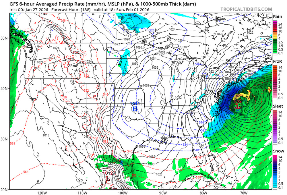
-
Possible coastal storm centered on Feb 1 2026.
tiger_deF replied to Typhoon Tip's topic in New England
Found it!
-
Snowbands are building remarkably well in CNE and western New England - hoping to grab at least 2-3" out of this
-
Possible coastal storm centered on Feb 1 2026.
tiger_deF replied to Typhoon Tip's topic in New England
Four across four down is absurd, over 2.5 in of QPF in eastern mass. While the ratios might be lower than this weekend's system, that would be substantially more snow. -
I think a swath of eastern MA won't have any break in the snow until the last of the coastal bands move offshore
-
Actually the Euro, ICON, and CMC all have some version of this same storm - but vary widely on if it is offshore or over land
-
Spins a miller A storm out of what seems like nothing - a little offshore, but down to the 960's! Now that we got a huge moisture thump I would love a classic Nor'easter with moving drifts, howling winds, and heavy heavy snow rates
-
Snow has been coming down hard for the past 6 hours. Hard to tell with the drifting but in Arlington MA I'd say we have 15-17" so far. If the storm continues to print in the remaining 4-5 hours of heavier snow, and if Monday pans out, wouldn't be surprised to see 24-30"
-
It's so easy to tell - real life is less "concentrated" than AI imagery. Even situations of joy and devastation will have areas of normalcy. AI interprets the user's request - often of dramatics and absurdity - and has no choice but to paint an image that is 100% to satisfy its loss function per the user query. Even as AI has gotten so realistic, the way people use it sure hasn't
-
WE ALL WE NEED!!! LET'S GOO!!!!!!!
-
15 degrees in Arlington and still snowing at a decent clip - doesn't look heavy but the accumulation is no joke. 10" ± 1" , shoveling this is like shoveling sand. Took me 20 minutes to shovel but there was easily a half an inch where I shoveled first.
-
When’s the heaviest snow supposed to hit Boston?
-
Measured 2.5” in Arlington at 10 degrees, arctic sand but accumulating at a steady rate. Go Pats! We all we got!!
-
NE of Boston and we had a nice band come through earlier - but we are also back to arctic sand
-
Love me a sour monkey, one of my favorite sour beers. They sneak up quickly though - easy to forget that each one is the equivalent of 2-3 light beers. Though if you want to be doing snow angels outside in the dark at the height of the storm then it's easily the best option
-
What are we drinking? I'm incredibly partial to Sam Adam's Winter Ale - got a six pack and have cracked the first pregame beer
-
8 degrees and still snowing lightly in Arlington, ready for the band pushing north. Should be here in a half an hour or so. We have 0.5" on the ground
-
I have two 50 dollar bets that we get over 2 feet, this is music to my ears
-
Just a coating on the ground here in Arlington. It’s so cold that it’s directly accumulating on the roads - driving conditions are terrible (for a prius)
-
I’ll be shocked if Stidham isn’t benched by halftime. Real question is if we’ll have a pick six before or after an inch of accumulation
-
I’m ready to get into nowcasting mode soon. Seems that snow and sleet have started earlier than predicted for some folks in the Midwest and south - while there’s a large dry slot between the north and southern rails of precipitation, leaving AK and south TX in a snow hole