Cary67
-
Posts
1,572 -
Joined
-
Last visited
Content Type
Profiles
Blogs
Forums
American Weather
Media Demo
Store
Gallery
Everything posted by Cary67
-
I would of thought you cashed in on a little LES. After the fast start its been mostly dusters here since Dec8th. Further east into downtown and north shore they've had some LES events. Every mile east of here matters as far as LES and being more under the clipper track this year. RFD still at 24" for the season but ORD up at 31"+. DTW even better along with a lot of Ohio relative to averages
-
Broom job #8
-
Winter 2025-26 Medium/Long Range Discussion
Cary67 replied to michsnowfreak's topic in Lakes/Ohio Valley
Benjamin Button words of wisdom
-
Winter 2025-26 Medium/Long Range Discussion
Cary67 replied to michsnowfreak's topic in Lakes/Ohio Valley
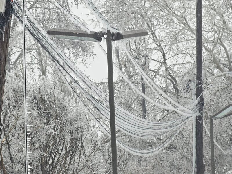
From LOT AFD: Also have to point out a growing signal for a southwest-flow synoptic scale cyclone somewhere east of the Rocky Mountains in the February 11-14 timeframe, with both the GEFS/EPS already favoring our area being on the warm side. Should a cyclone actually develop and we end up on the warm side, could easily envision forecast focus trending toward hydrology concerns considering the frost depth of just deeper than 13 inches at our office isn`t going to vanish anytime soon. -
RFD had 4.7" ORD 11.1" Jan.totals Average January ORD monthly totals 11.1" Difference mostly LES. MBY somewhere between those so would give the month a C-. Mostly swiped by dusters and flakes in the air from distant LES. Trough position too far east with us sitting on backside. If pattern resets ideally trough digs back further west if not could be repeat of January.
-
1/30-1/31 Lake Effect Snow Threat - SE WI, NE IL, and NW IN
Cary67 replied to A-L-E-K's topic in Lakes/Ohio Valley
Was in Northbrook most of the day. It was ripping at times. Sad to head back to dust town -
Winter 2025-26 Medium/Long Range Discussion
Cary67 replied to michsnowfreak's topic in Lakes/Ohio Valley
Hopefully. This weekend is approximately duster event #9 for my area. At about 26-27" on the season. RFD lagging a bit at 23.9" -
That's nice. No chance for blowing and drifting on the way back and forth to Iowa City
-
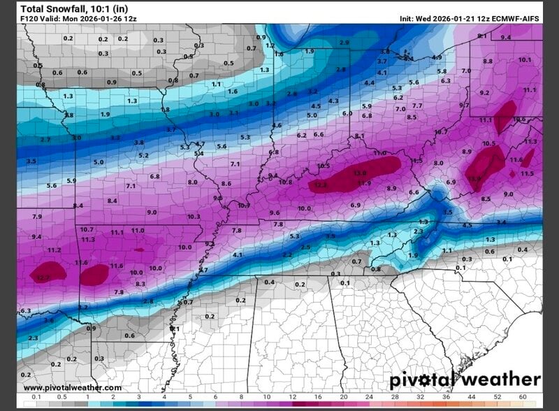
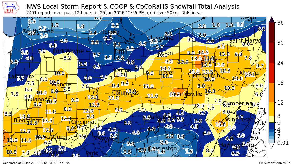
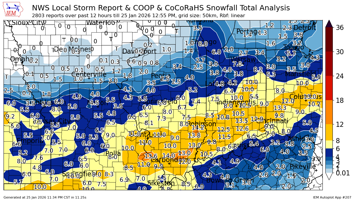
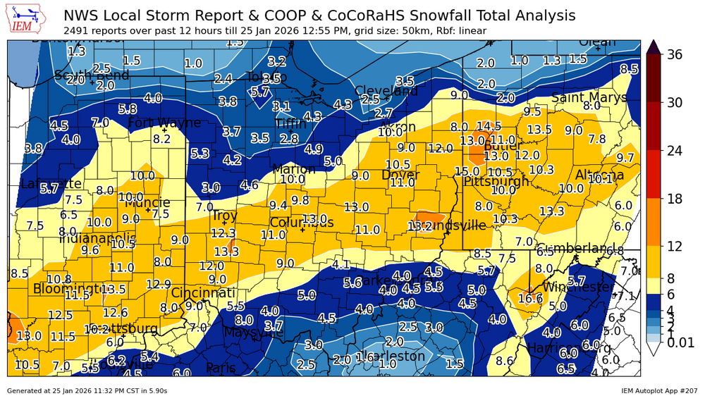
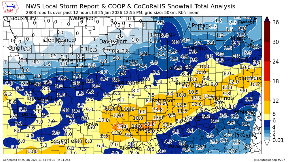
1/24-1/25 Major Winter Storm - S. IL, IN, and OH
Cary67 replied to A-L-E-K's topic in Lakes/Ohio Valley
-
1/24-1/25 Major Winter Storm - S. IL, IN, and OH
Cary67 replied to A-L-E-K's topic in Lakes/Ohio Valley
-
1/24-1/25 Major Winter Storm - S. IL, IN, and OH
Cary67 replied to A-L-E-K's topic in Lakes/Ohio Valley
Hopefully LES totals didn't skew ORD official numbers too much -
1/24-1/25 Major Winter Storm - S. IL, IN, and OH
Cary67 replied to A-L-E-K's topic in Lakes/Ohio Valley
Definitely. Will ease this weekends swing and miss out here. -
1/24-1/25 Major Winter Storm - S. IL, IN, and OH
Cary67 replied to A-L-E-K's topic in Lakes/Ohio Valley
They steal one at Mackey? -
1/24-1/25 Major Winter Storm - S. IL, IN, and OH
Cary67 replied to A-L-E-K's topic in Lakes/Ohio Valley
Lake bake making the cake -
1/24-1/25 Major Winter Storm - S. IL, IN, and OH
Cary67 replied to A-L-E-K's topic in Lakes/Ohio Valley
I tend to follow certain markers. If it's snowing hard in Evansville it's not snowing much here. If the SLP track is taking the little Egypt route I'm in business. Chicago seems more in play with these southern systems since you'll get this LES signal to show up fluffing up totals. Sometimes comes to fruition; a lot of times doesn't. I always figure qpf is overdone on the margins and will erode away as event nears provided there's no consensual shift of the models NW -
-11F this morning Edit:-12F currently
-
1/24-1/25 Major Winter Storm - S. IL, IN, and OH
Cary67 replied to A-L-E-K's topic in Lakes/Ohio Valley
Call of 1.0" here -
Winter 2025-26 Short Range Discussion
Cary67 replied to SchaumburgStormer's topic in Lakes/Ohio Valley
Snowmobiling Edit: Helps with north facing yard also
-
1/24-1/25 Major Winter Storm - S. IL, IN, and OH
Cary67 replied to A-L-E-K's topic in Lakes/Ohio Valley
One last jolt from the paddles before last rites read -
Winter 2025-26 Medium/Long Range Discussion
Cary67 replied to michsnowfreak's topic in Lakes/Ohio Valley
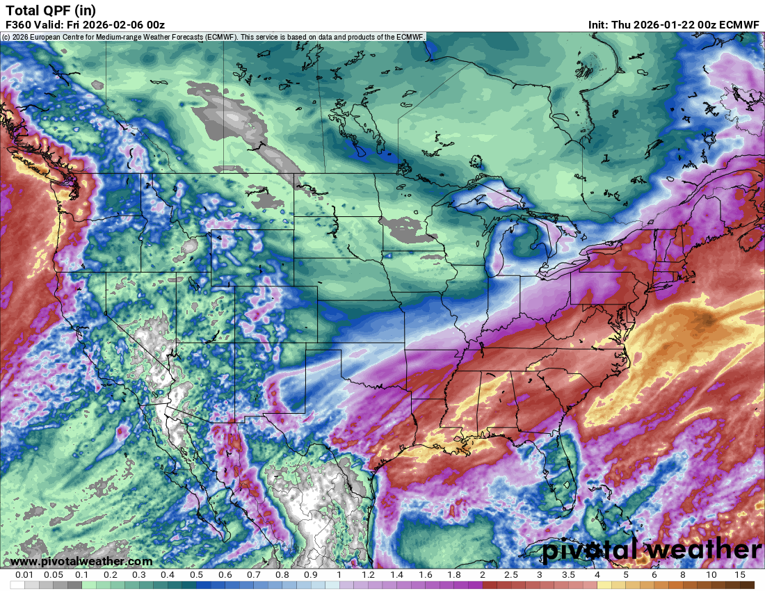
Seemed to remember endless dry qpf EMCF maps last year. At some point in February figure trough lifts out of the east and we get another wet cutter as ridge out west sloshes east ala mid December.Trough probably redigs in same location at some point later
-
1/24-1/25 Major Winter Storm - S. IL, IN, and OH
Cary67 replied to A-L-E-K's topic in Lakes/Ohio Valley
Thx. Remember the near misses more than the hits -
1/24-1/25 Major Winter Storm - S. IL, IN, and OH
Cary67 replied to A-L-E-K's topic in Lakes/Ohio Valley
Was that the downtown lake effect special? -
1/24-1/25 Major Winter Storm - S. IL, IN, and OH
Cary67 replied to A-L-E-K's topic in Lakes/Ohio Valley
Would think it's a step back. Especially compared to 0Z ECMF run -
1/24-1/25 Major Winter Storm - S. IL, IN, and OH
Cary67 replied to A-L-E-K's topic in Lakes/Ohio Valley
Would expect qpf numbers to dry up a bit and models usually are overdone at this range. -
1/24-1/25 Major Winter Storm - S. IL, IN, and OH
Cary67 replied to A-L-E-K's topic in Lakes/Ohio Valley