Weather Will
-
Posts
7,604 -
Joined
-
Last visited
Content Type
Profiles
Blogs
Forums
American Weather
Media Demo
Store
Gallery
Everything posted by Weather Will
-
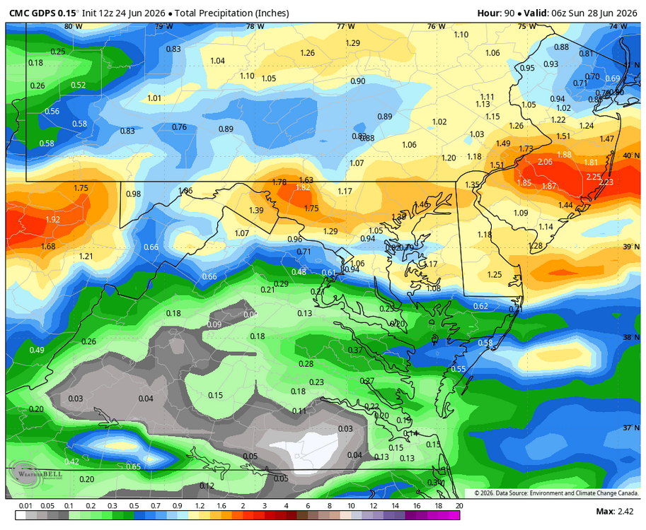
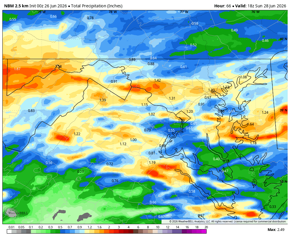
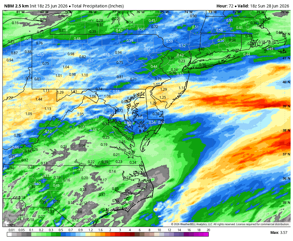
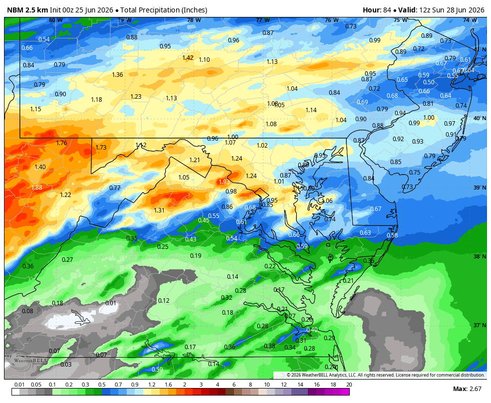
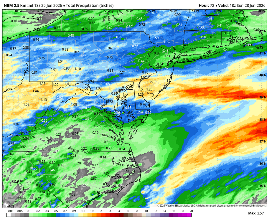
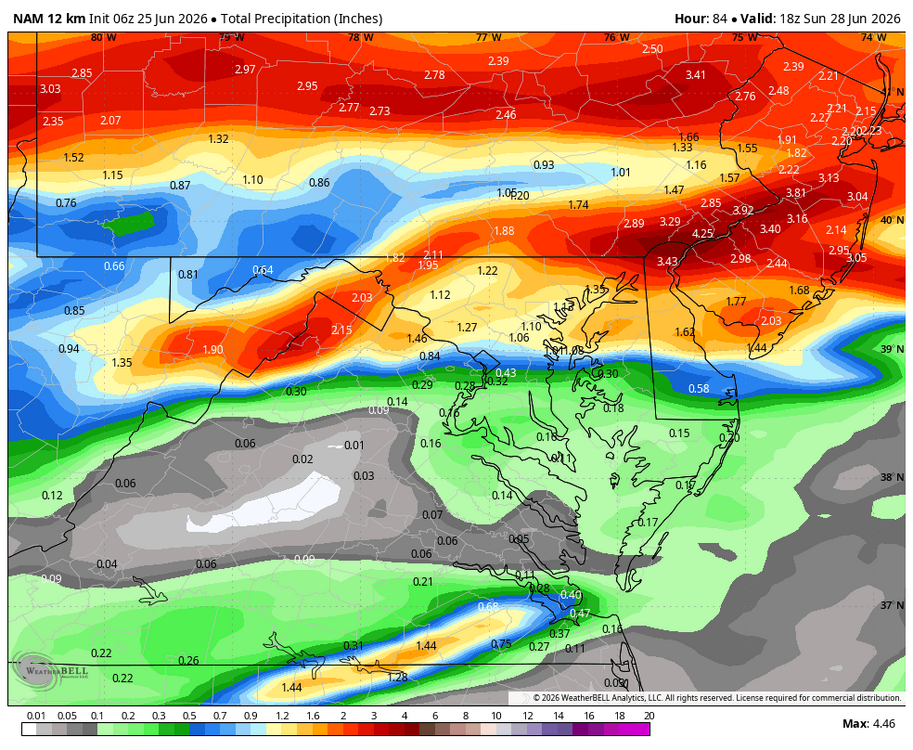
WB 12Z NBM through weekend. Most of this falls late Saturday/ Sunday.

-
Mod; please pin.
-
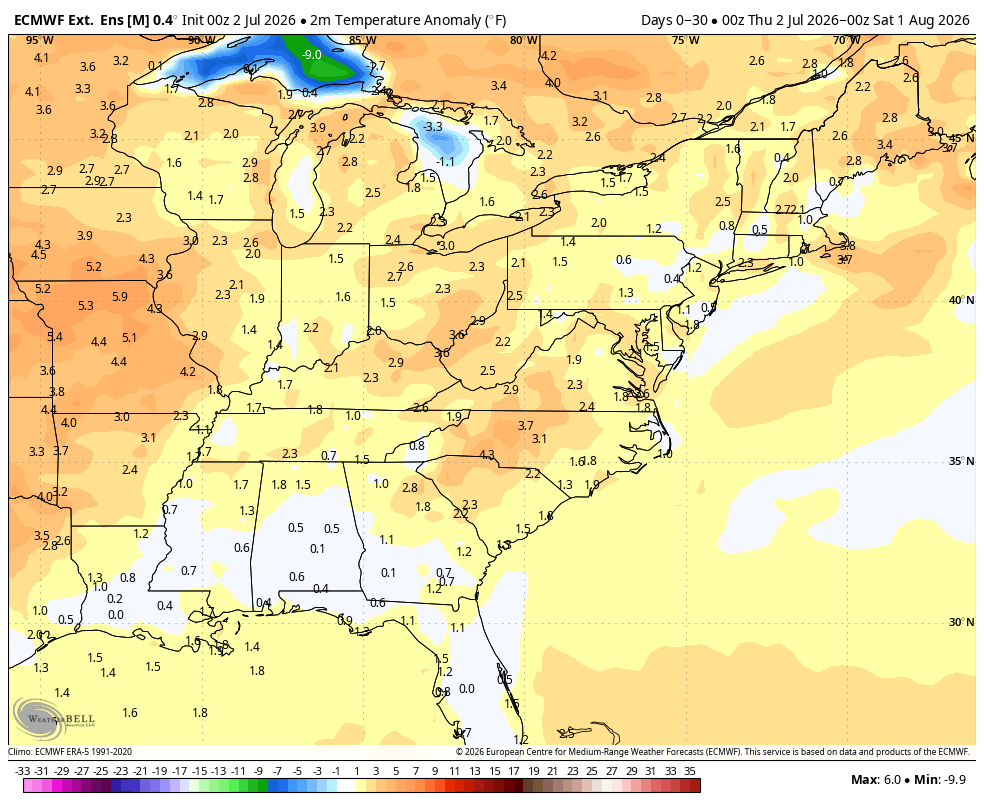
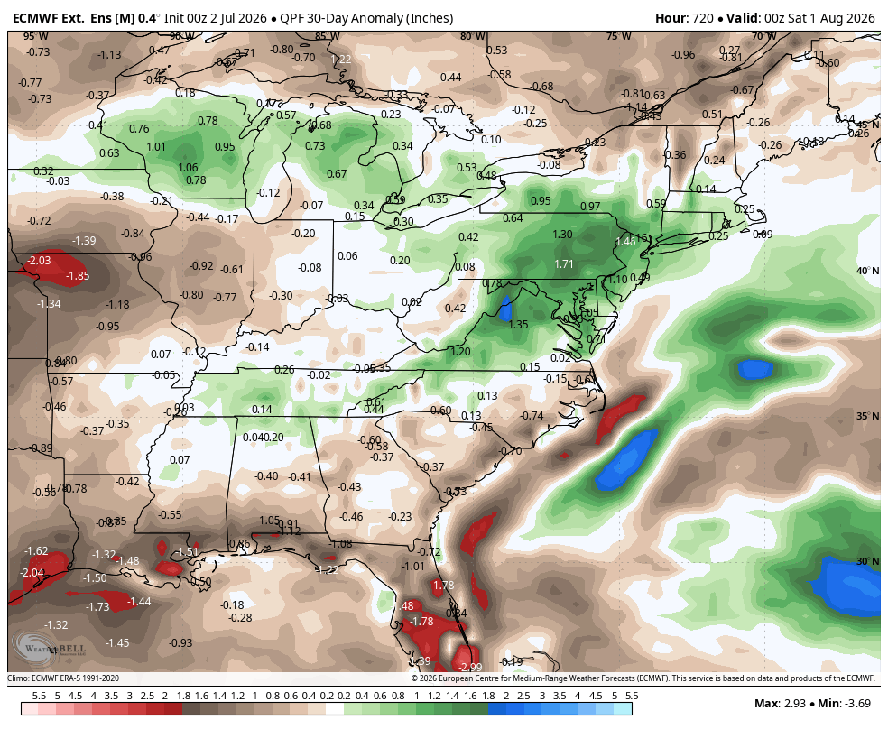
WB latest EPS for July. Warm and Wet! Hope it's correct.


-
Big Heat (and storms?) Week into July 4th Weekend
Weather Will replied to yoda's topic in Mid Atlantic
Ok thought we were using it for the weekend.... I will start a July mid range thread. -
Big Heat (and storms?) Week into July 4th Weekend
Weather Will replied to yoda's topic in Mid Atlantic
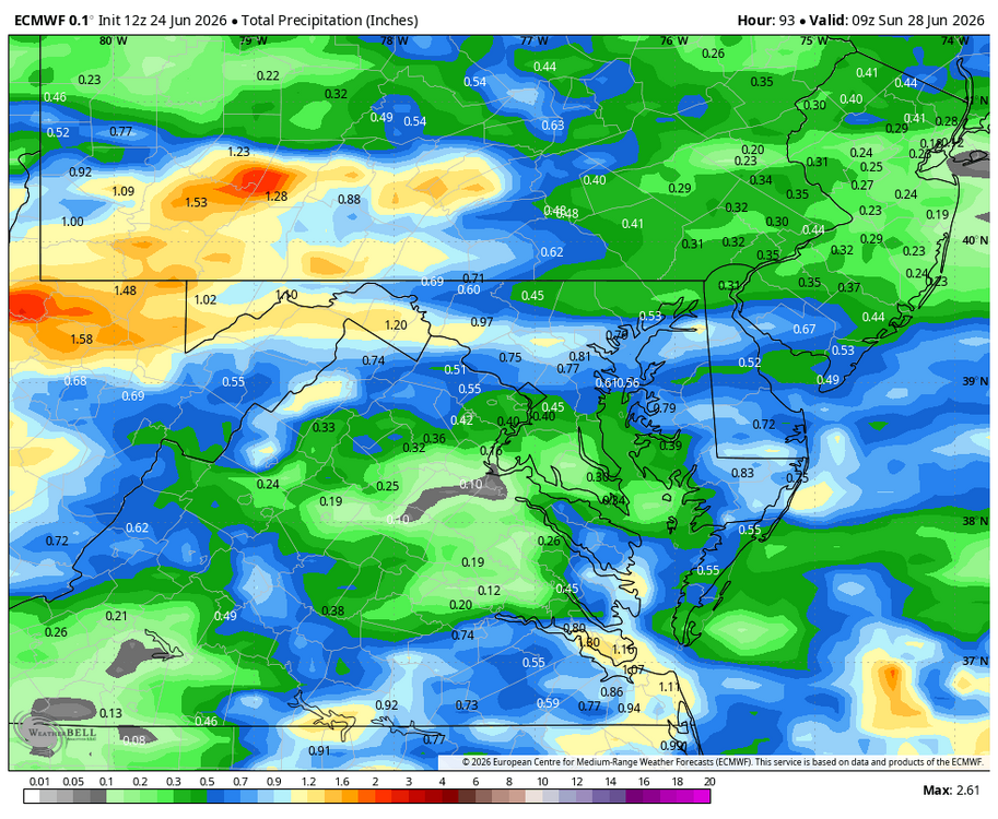
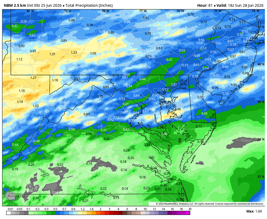
WB 12Z NBM: rain totals through the weekend. Most of this rain falls later Saturday/Sunday.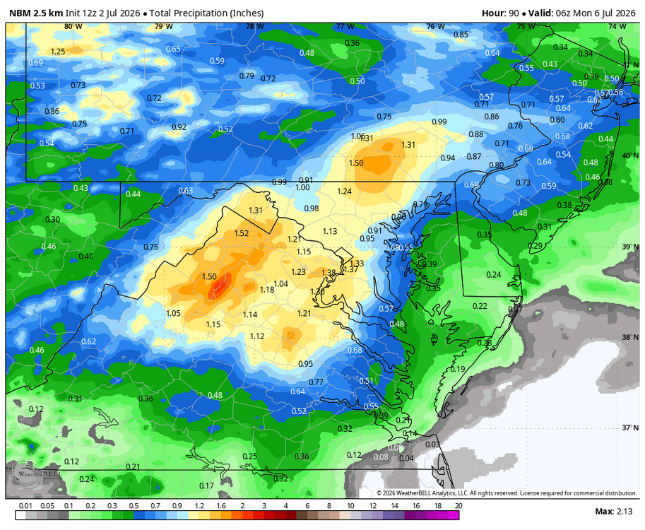
-
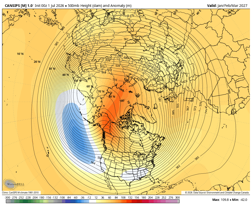
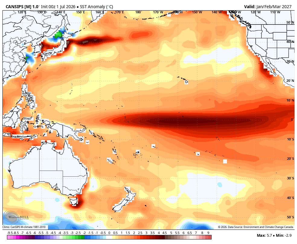
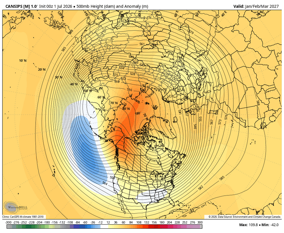
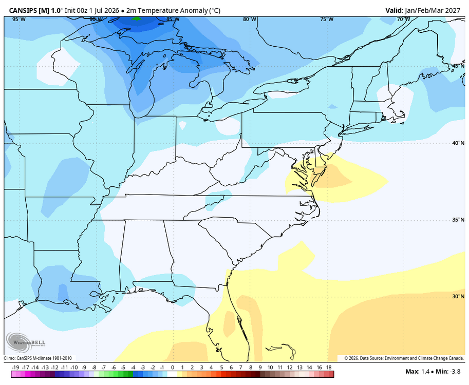
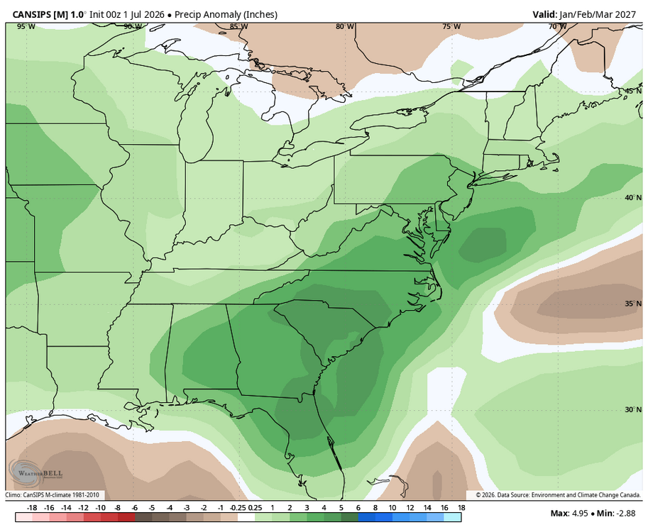
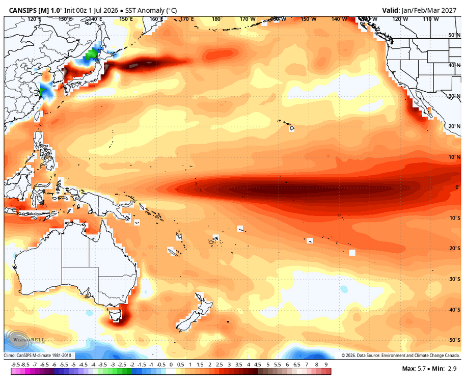
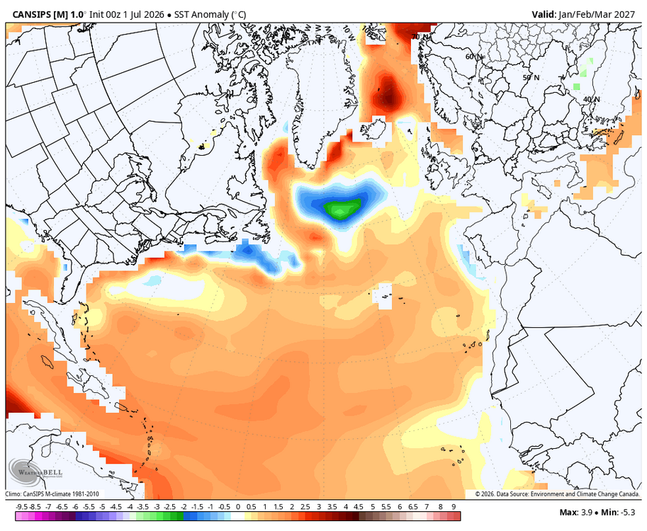
WB 7/1 Canad. Jan-Mar. looks wet, hopefully will get enough cold...
-
Time to start a July thread! Latest weekly EPS for July.
-
Big Heat (and storms?) Week into July 4th Weekend
Weather Will replied to yoda's topic in Mid Atlantic
Detailed analysis in latest NWS Sterling discussion for the upcoming heat wave/ thunderstorm threat. Nice read with information that hopefully will keep people safe in the upcoming heat wave. Area Forecast Discussion National Weather Service Baltimore MD/Washington DC 345 PM EDT Tue Jun 30 2026 .WHAT HAS CHANGED... The Heat Advisory for Wednesday has been expanded to include Calvert and St. Mary`s Counties. The Extreme Heat Watches for Thursday and Friday have been expanded to include Green, Albemarle, Nelson, Augusta, and Rockingham Counties. Have included brief low precipitation chances focused around subtle boundaries over the next few days. DISCUSSION... KEY MESSAGE 1...Extreme heat builds over the region through at least the end of the week. What may turn out to be the most intense heat wave since 2012 is on our doorstep. It is important to plan ahead on how to best keep safe from the heat. Have a plan on how to stay cool (and hydrated). Tips for the heat... -Keep Cool: If there is not access to air conditioning, you can look up nearby cooling centers through local county websites. Buildings that do not have air conditioning may remain hot for several days after the worst of the heat wave. -Stay Hydrated: Remember that drinks containing alcohol or caffeine actually dehydrate, so balance that with water or sports drinks. -Take It Easy: Try to limit strenuous outdoor activity (work, exercise, etc.) to early morning or late evening when it`s not as hot. -Dress For Heat: Wear lightweight, light-colored, loose fitting clothing; this helps reflect the sun and allows for airflow to keep cooler. -Look Before You Lock: Never leave anyone unattended in a vehicle as temperatures can reach lethal levels in a matter of minutes. -Check In With Each Other: Check in on family, friends, and neighbors. The elderly, very young, and those with compromised immunity or mental health are at an increased risk from heat. -Be Aware: Stay tuned to the latest heat alerts and forecast from NWS, and be mindful that prolonged extreme heat could impact power, water, and transportation systems. The meteorology... Low-level moisture has increased substantially with dew points well into the 70s in the valleys west of I-81. Combined with widespread air temperatures to around 90, this is resulting in heat index values of 100 to 105 in the lower elevations of western MD and eastern WV in the lee of the Appalachian crest. The heat will continue to build Wednesday as ridging continues to strengthen just to the south and west. Temperatures soaring well into the 90s with dew points in the upper 60s (west of the Blue Ridge) to lower 70s (east of the Blue Ridge) will lead to heat index values around or a little over 100 (west) and 105 (east) during the afternoon hours. This is covered with a Heat Advisory for all except the higher elevation zones, although there is growing concern that prolonged abnormal heat even at higher elevations could be impactful where there is limited AC available. Will evaluate as the event draws near to see if those zones need to be added. In the meantime, have expanded the advisory into Calvert and St. Mary`s Counties. It looks like the low-level moisture gets there a bit quicker than in previous cycles of guidance, possibly aided by slightly higher surface dew points in the vicinity of the tidal Potomac River and the Chesapeake Bay. Extreme Heat Watches remain in effect for Thursday through Friday when the heat peaks, and have been expanded to include all but the higher elevation zones (though again concern is growing for impactful heat even at higher elevations). Air temperatures are likely to near record values Thursday and Friday. Dew points will remain elevated especially east of the Blue Ridge resulting in widespread heat index values well over 100, with increasing potential to exceed 110 east of the Blue Ridge toward the metros. Areas near larger bodies of water (tidal Potomac River, Chesapeake Bay) could see spotty heat indices near 115 at times. The heat is likely to continue into Saturday, though the exact magnitude becomes increasingly uncertain several days out. This uncertainty is also raised due to potential for showers and thunderstorms that could put a lid on temperatures. Heat headlines are likely at some point, but confidence in reaching widespread warning criteria is low for now. Either way, it will likely be very impactful given it will be several days in a row of high heat and humidity. Sunday looks relatively "cooler" though temperatures likely still reach the 90s with elevated humidity. This could push us close to Heat Advisory criteria once again. Even at night, temperatures will stay in the 70s for most (perhaps not falling below 80 in the major urban centers). This keeps heat indices in the 90s most of the night, offering little to no relief from the heat. Lastly, the intense heat and humidity will likely result in poor air quality at times. Visit your state`s air quality information website for more information. KEY MESSAGE 2...Thunderstorm chance increase through this weekend, with an increased risk for severe thunderstorms Friday into the Independence Day weekend. With excessive heat and humidity comes the potential for severe weather as abundant instability and moisture pool over the region. Any showers and thunderstorms through mid week should be very spotty. A few spots to look out for: near the intersection of a bay breeze and lee pressure trough Wednesday afternoon, and near the higher terrain Thursday afternoon. Most of the area/time will be dry, but any storms that do manage to form could produce very gusty winds, frequent lightning, and torrential downpours or even some hail given large amounts of potential energy (CAPE). Upper-level ridging will gradually buckle Friday before flattening over the weekend into early next week as the broad subtropical high pressure shifts further offshore and a series of shortwave disturbances pivot through. Timing and coverage of storms have yet to be determined given the placement of synoptic/mesoscale features. With that said, looking at scattered strong to severe thunderstorms mainly during the afternoon and evening period with damaging wind gusts, large hail, heavy rainfall, and frequent lightning as the main threats. Storms may be of the pulse variety likely forming along the lee side trough east of the Alleghenies or residual outflows (i.e the bay/river breeze) due to the lack shear aloft Friday into Saturday. Of course this is subject to change based on any ripples of energy that move between over top of the ridge shunted to the south and the jet stream to the north (Great Lakes/Ohio River Valley). If this were to occur, we could be looking at more organized and widespread storm clusters, but confidence in this is low at this time. Multiple instances of deterministic/ensemble guidance illustrate this on both Saturday into Sunday as the ridge flattens further. Google AI WxNet along with CIPS/CSU AI probs illustrate this with rather high probabilities of severe weather this weekend. As we approach the Independence Day weekend, have a weather preparedness plan ready to go, especially if you are outdoors (i.e at a picnic with family or a fireworks show). Plan ahead for any outdoor activities this weekend, as they are likely to be interrupted by storms at some point. Have a way to get trusted warnings, download a radar/lightning app to keep aware of changing weather conditions, and know when to act. When thunder roars, go indoors. Lightning can strike up to 15 miles outside of the core of thunderstorms, so wait 30 minutes after that last rumble of thunder before resuming outdoor activities. Given the heat in place, some storms could be quite intense (if they form). From a historical perspective, prolonged near record heat in summer often ends in a period of strong storms. Intense storms can produce hail and high winds in addition to rain and lightning, so having access to sturdy shelter is important. -
Big Heat (and storms?) Week into July 4th Weekend
Weather Will replied to yoda's topic in Mid Atlantic
For those that want to cool off.... Advisories One product issued by NWS for: 5 Miles N Deer Lodge MT Winter Storm Warning URGENT - WINTER WEATHER MESSAGE National Weather Service Missoula MT 616 PM MDT Sat Jun 27 2026 MTZ007-280830- /O.CON.KMSO.WS.W.0004.000000T0000Z-260629T1500Z/ Butte/Blackfoot Region- 616 PM MDT Sat Jun 27 2026 ...WINTER STORM WARNING REMAINS IN EFFECT UNTIL 9 AM MDT MONDAY ABOVE 6500 FEET... * WHAT...Heavy wet snow expected above 6500 feet. Total snow accumulations of 4 to 8 inches, with 8 to 16 inches across the Anaconda Pintler Mountains. Snow levels may briefly lower and could produce minor slushy accumulation at Homestake and Macdonald Pass. * WHERE...Georgetown Lake, backcountry and higher elevation areas. * WHEN...Until 9 AM MDT Monday. * IMPACTS...Plan for winter-like conditions in the backcountry and higher elevations. Cold temperatures, wind, and wet snow will elevate the risk of hypothermia. Heavy wet snow may down trees, blocking access to backcountry roadways. -
Light rain/ drizzle from Brunswick to Frederick this am along with patchy fog. Pleasant surprise, not a drought buster but everything is wet!!!
-
It is raining!!!!
-
Ok, I will jump into this crap for one post as a recently retired Fed. The federal workforce will take decades if ever to recover from the last two years. While dedicated, hard working employees remain to fulfill their agency's respective missions as best they can, the number of us that retired or left has wiped out institutional knowledge, expertise, chains of command, infrastructure, and succession plans. Budget cuts also inhibit technology upgrades that could make up for the lack of human resources. It is a mess!!!! People are doing the best they can. If you don't like things, write your respective Congressional delegations and vote this fall. This post can be moved to banter or deleted when the others are as well but don't disparage the few remaining feds trying to keep things going....
-
Where is Mappy to clean up this thread!
-
Radar looks like it is trying to fill in to my west; fingers crossed...
-
Seems like the only thing that verifies in the long range nowadays is a heat wave...
- 259 replies
-
- 1
-

-
- we got burned
- rugpull central
- (and 1 more)
-
Light showers, need every drop before the upcoming heatwave.... .10 so far today.
-
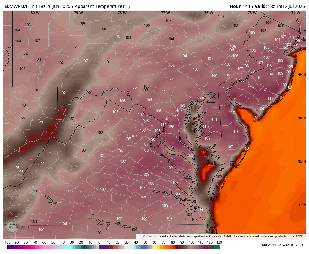
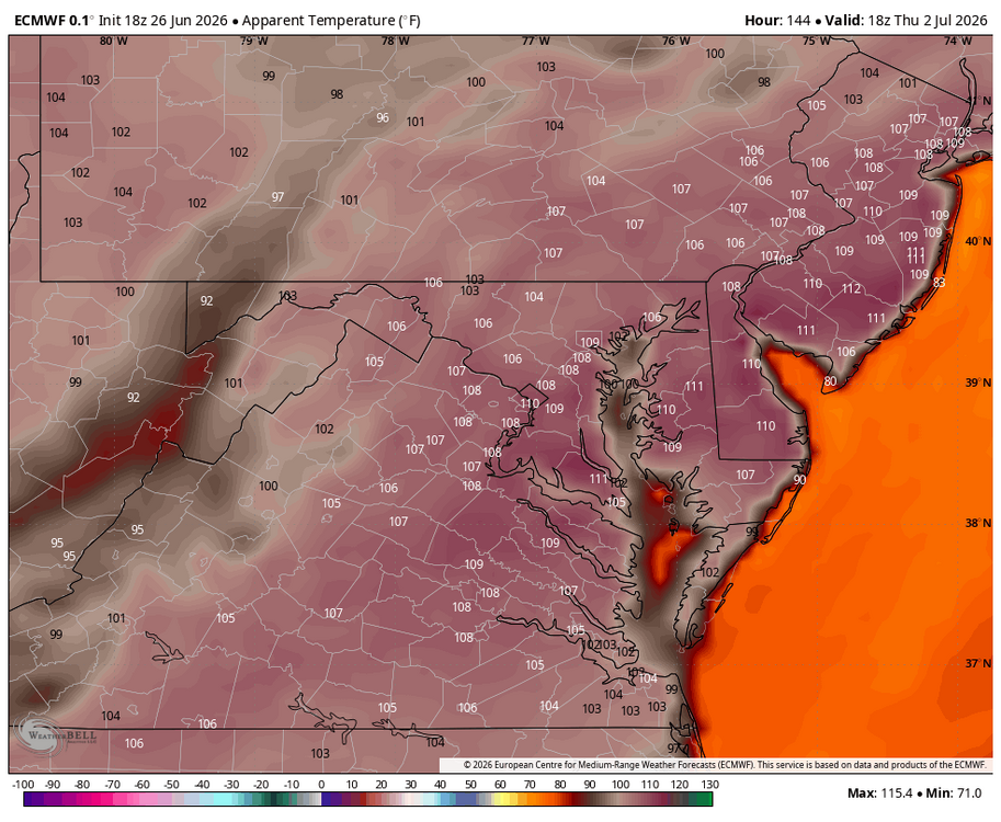
WB 18Z EURO apparent temps for Th.
- 259 replies
-
- 1
-

-
- we got burned
- rugpull central
- (and 1 more)
-
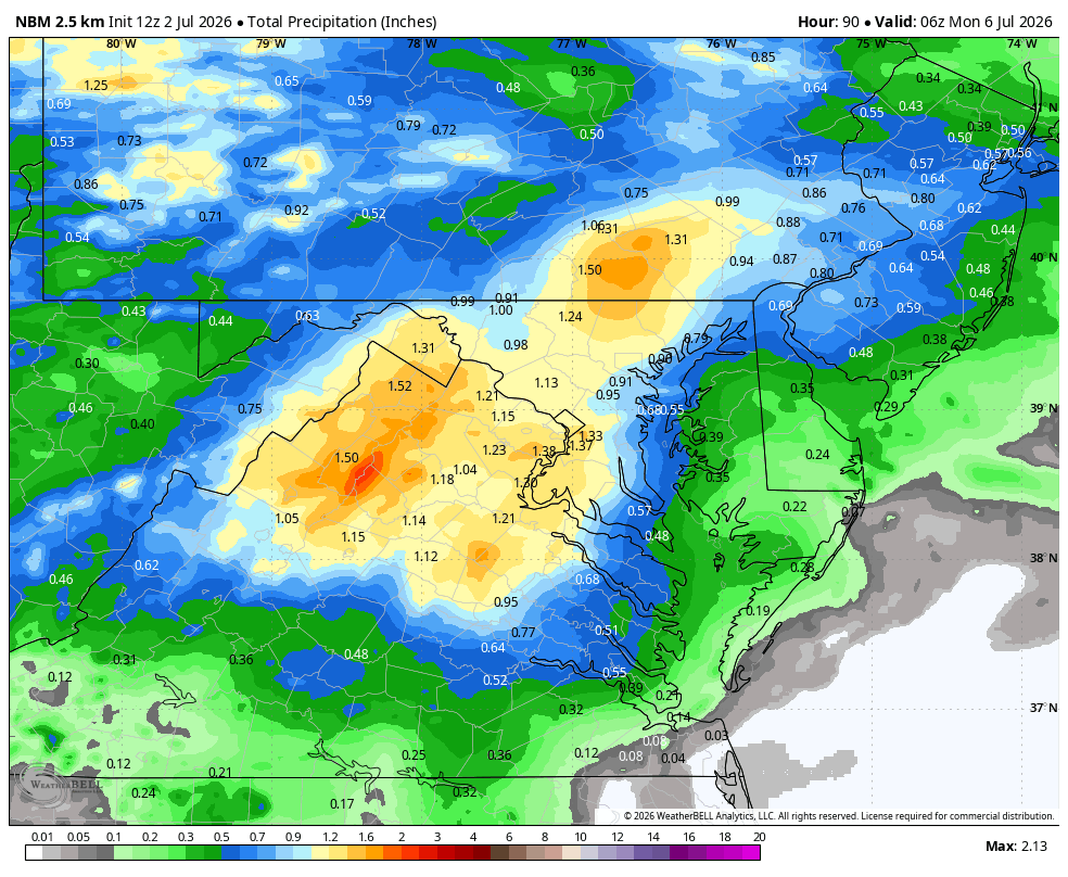
WB 0Z NBM

-
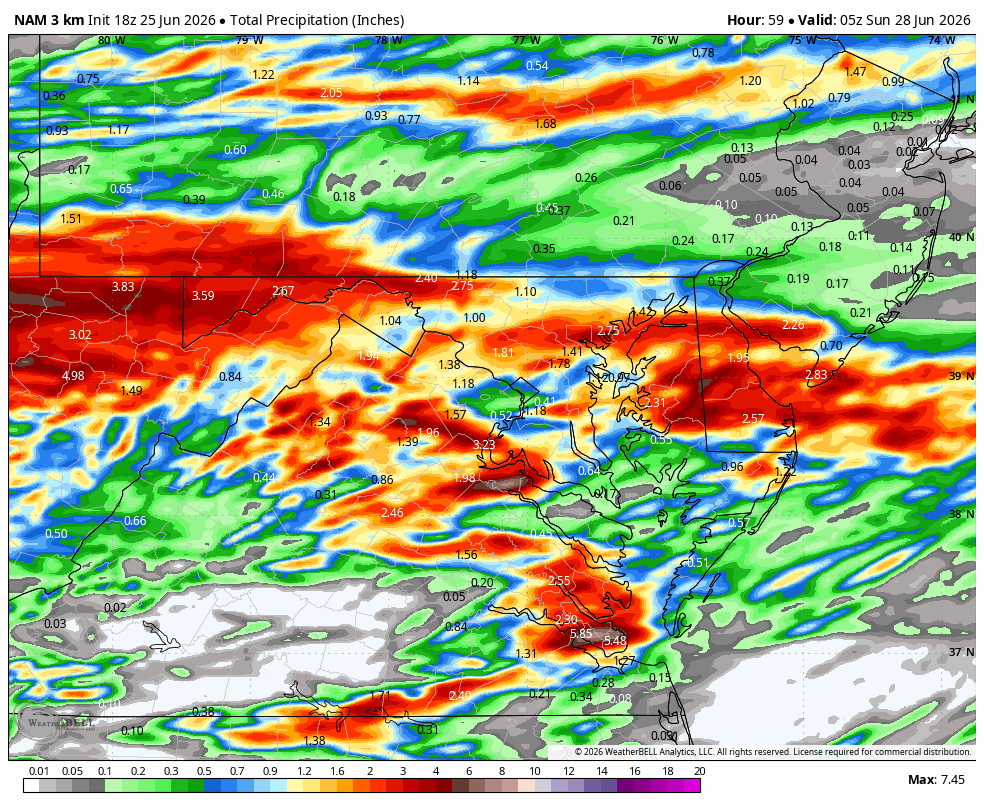
Yes!!! And not done at HR 60. WB 18Z 3K NAM

-
By the way my, site very slow for 2 days. Keep getting upload errors...
-
WB 18Z NBM; better than I expected.
-
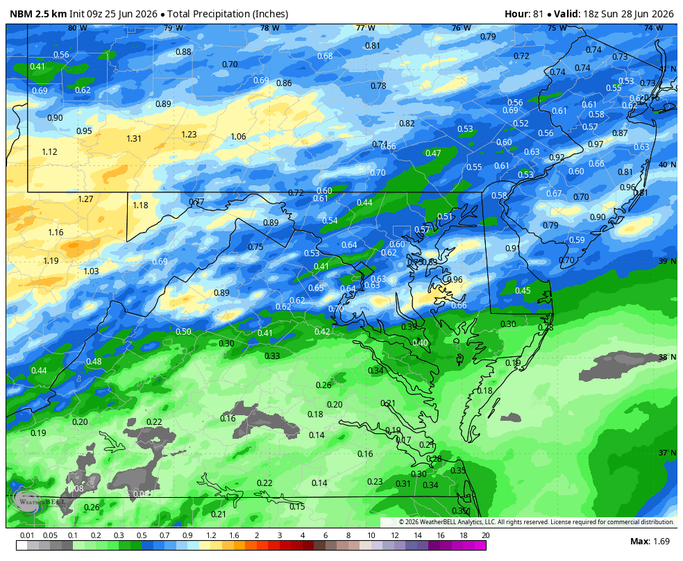
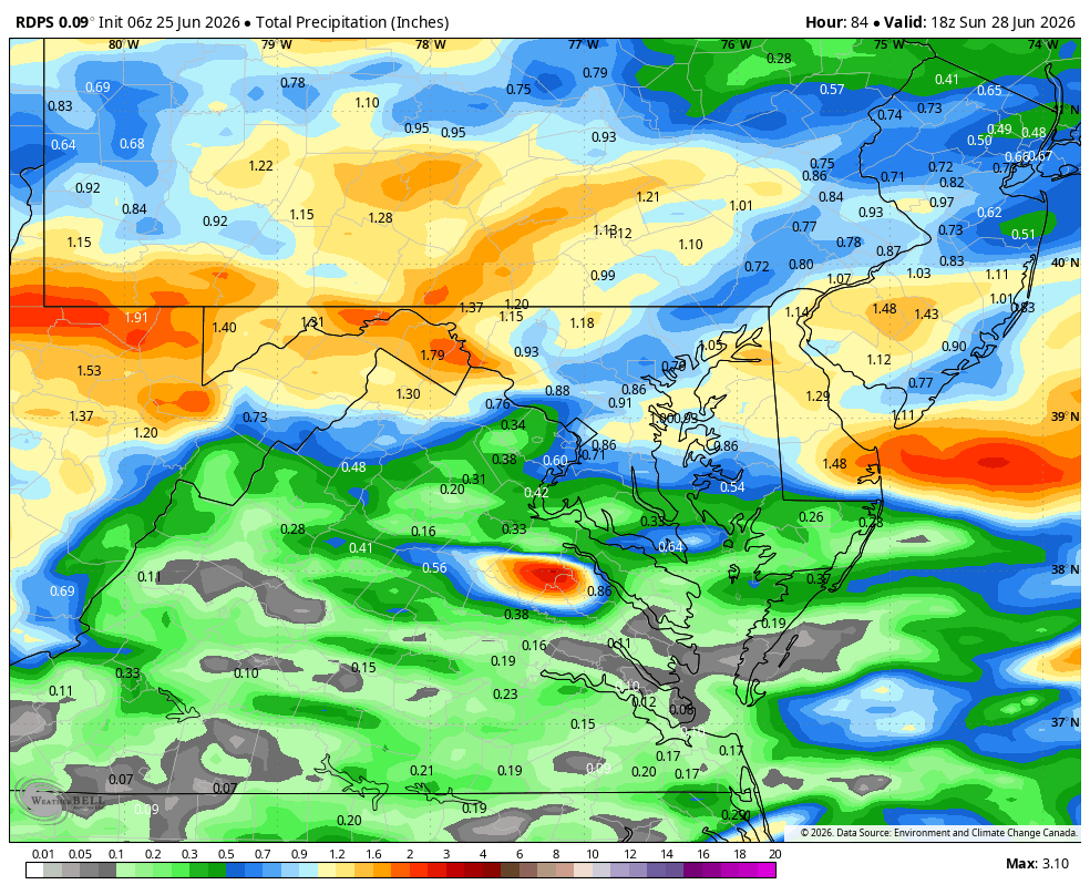
WB 9Z NBM...here we go again... but don't worry the WB 6Z 12K NAM will save us! Actually, the WB 6Z RDPS is ok for northern areas as well. We are still in wait and see mode...

-
WB 0Z NBM

-
Excerpt from latest Sterling NWS discussion. They should use this line for every event.... In short, it is a very complex forecast situation, so stay tuned to the latest forecast for updates as we get to look at more data.
-
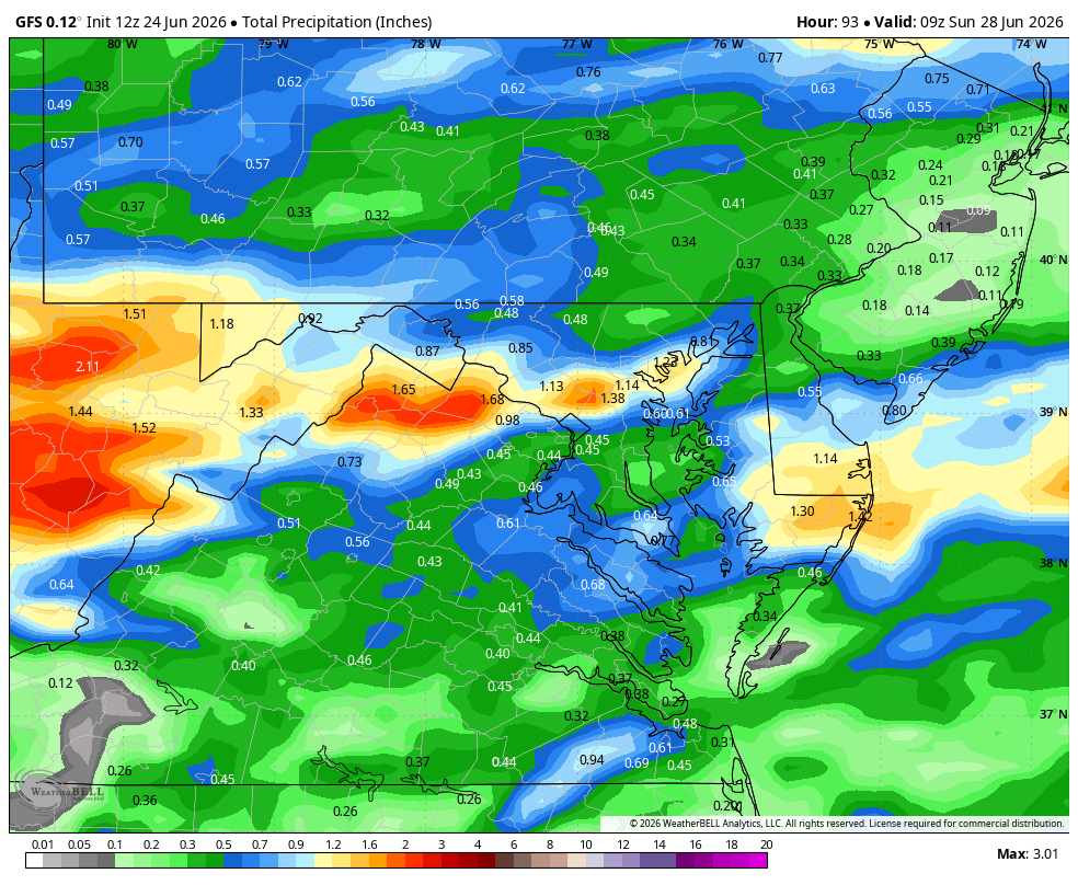
WB 12Z model runs: note GFS has rain coming in Friday evening; RRFS and 12K NAM are nothing burgers (not shown); Canadian on board; EURO