Weather Will
-
Posts
7,602 -
Joined
-
Last visited
Content Type
Profiles
Blogs
Forums
American Weather
Media Demo
Store
Gallery
Everything posted by Weather Will
-
Beautiful Day for a Walk Warning in Effect! Can't beat today in mid July,,,,,ENJOY!
-
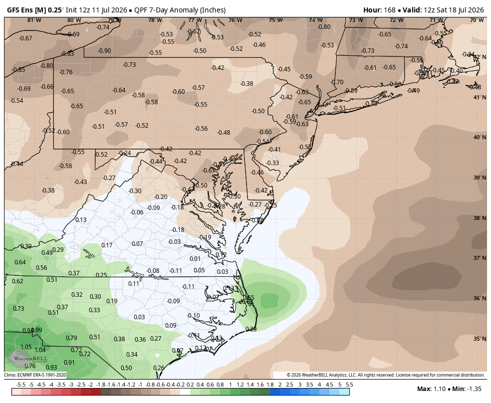
WB 12Z EPS. Looks like a dry work week ahead.

-
Very light showers moved through. About .03.
-
1.30 for today. Over 3 inches for the month so far.
-
I don't know how reliable the Severe Weather Europe site is but like the read on the upcoming winter forecast for the polar vortex. https://www.severe-weather.eu/long-range-2/early-forecast-data-el-nino-polar-vortex-disruption-united-states-canada-europe-winter-2026-2027-fa/
-
Nice little rain falling. 4th day in a row with some rain. .09 today so far. 1.90 for month.
-
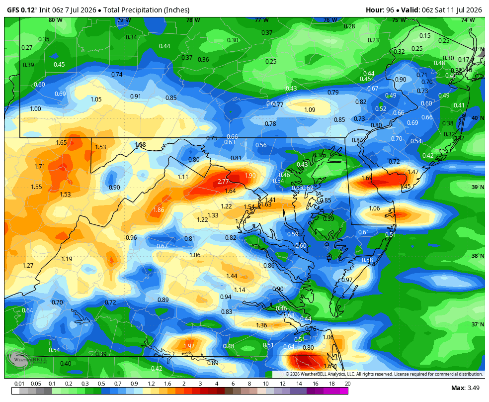
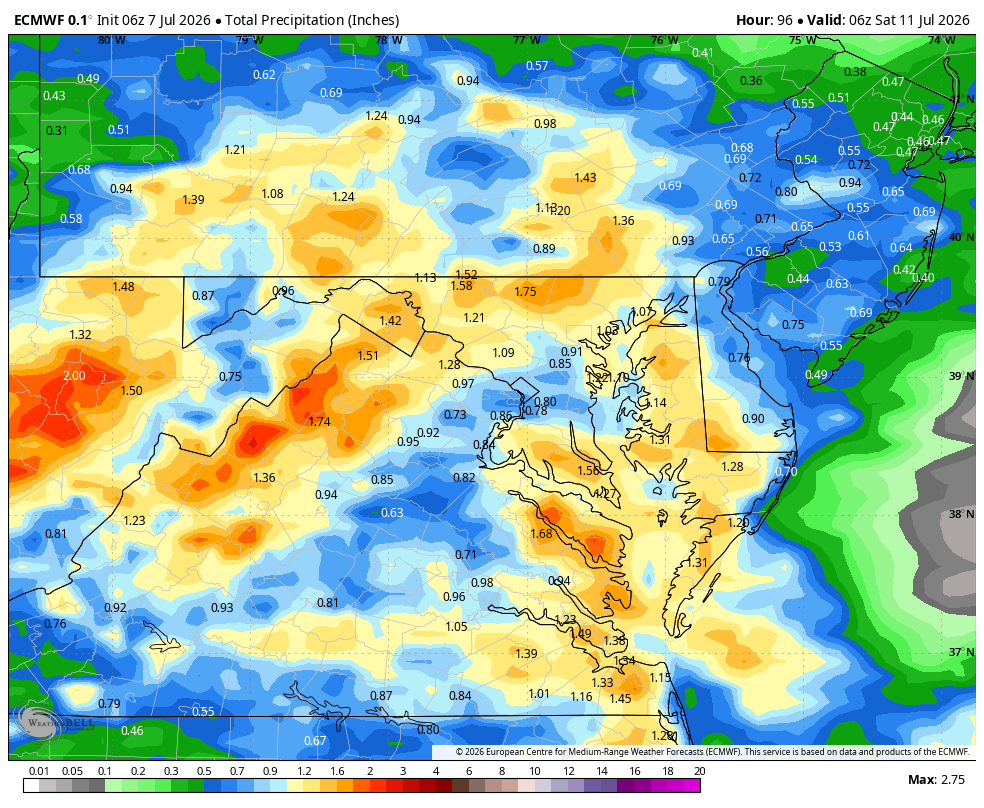
WB 6Z GFS and EURO through end of workweek.

-
Did receive some light rain before midnight. .30 for Tuesday.
-
I get it, but my forecast is for an 80% chance of rain....
-
Well, our flash flood watch is looking like a dud so far...what happened?
-
Flood Watch National Weather Service Baltimore MD/Washington DC 409 AM EDT Mon Jul 6 2026 ...The combination of a slow moving frontal zone with a tropical air mass in place will increase the risk of flash flooding this afternoon and evening... DCZ001-MDZ003>006-008-011-013-014-016>018-503>508-VAZ027>031-037>040- 050-051-053>057-501-502-505>507-526-527-WVZ051>053-061615- /O.NEW.KLWX.FA.A.0005.260706T2000Z-260707T0400Z/ /00000.0.ER.000000T0000Z.000000T0000Z.000000T0000Z.OO/ District of Columbia-Washington-Frederick-Carroll-Northern Baltimore-Cecil-Southern Baltimore-Prince Georges-Anne Arundel- Charles-St. Marys-Calvert-Northwest Montgomery-Central and Southeast Montgomery-Northwest Howard-Central and Southeast Howard-Northwest Harford-Southeast Harford-Shenandoah-Frederick- Page-Warren-Clarke-Albemarle-Greene-Madison-Rappahannock-Orange- Culpeper-Fairfax-Arlington/Falls Church/Alexandria-Stafford- Spotsylvania-King George-Northern Fauquier-Southern Fauquier- Western Loudoun-Eastern Loudoun-Northern Virginia Blue Ridge- Northwest Prince William-Central and Southeast Prince William/Manassas/Manassas Park-Morgan-Berkeley-Jefferson- 409 AM EDT Mon Jul 6 2026 ...FLOOD WATCH IN EFFECT FROM 4 PM EDT THIS AFTERNOON THROUGH THIS EVENING... * WHAT...Flash flooding caused by excessive rainfall is possible. * WHERE...Washington D.C., including the following areas in Maryland, Anne Arundel, Calvert, Carroll, Cecil, Central and Southeast Howard, Central and Southeast Montgomery, Charles, Frederick, Northern Baltimore, Northwest Harford, Northwest Howard, Northwest Montgomery, Prince Georges, Southeast Harford, Southern Baltimore, St. Marys and Washington, Virginia, including the following areas, Albemarle, Arlington/Falls Church/Alexandria, Central and Southeast Prince William/Manassas/Manassas Park, Clarke, Culpeper, Eastern Loudoun, Fairfax, Frederick, Greene, King George, Madison, Northern Fauquier, Northern Virginia Blue Ridge, Northwest Prince William, Orange, Page, Rappahannock, Shenandoah, Southern Fauquier, Spotsylvania, Stafford, Warren and Western Loudoun, and panhandle West Virginia, including the following areas, Berkeley, Jefferson and Morgan. * WHEN...From 4 PM EDT this afternoon through this evening. * IMPACTS...Excessive runoff may result in flooding of rivers, creeks, streams, and other low-lying and flood-prone locations. Flooding may occur in poor drainage and urban areas. * ADDITIONAL DETAILS... - Multiple rounds of heavy rainfall are possible this afternoon and evening, some of which may occur over areas which recently experienced flooding rains. Slow storm motions and repeat thunderstorm activity will occur within a tropical air mass. Hourly rainfall rates could push into the 2 to 3 inch range in the strongest storms, with even higher instantaneous rates. - Please visit www.weather.gov/safety/flood for flood safety and preparedness information PRECAUTIONARY/PREPAREDNESS ACTIONS... You should monitor later forecasts and be prepared to take action should Flash Flood Warnings be issued.
-
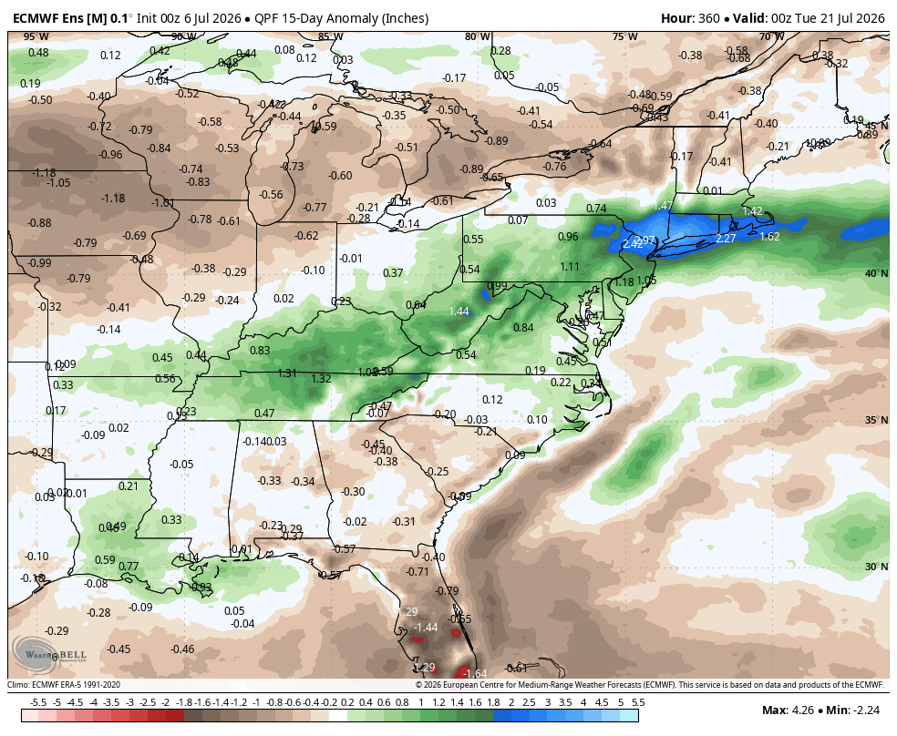
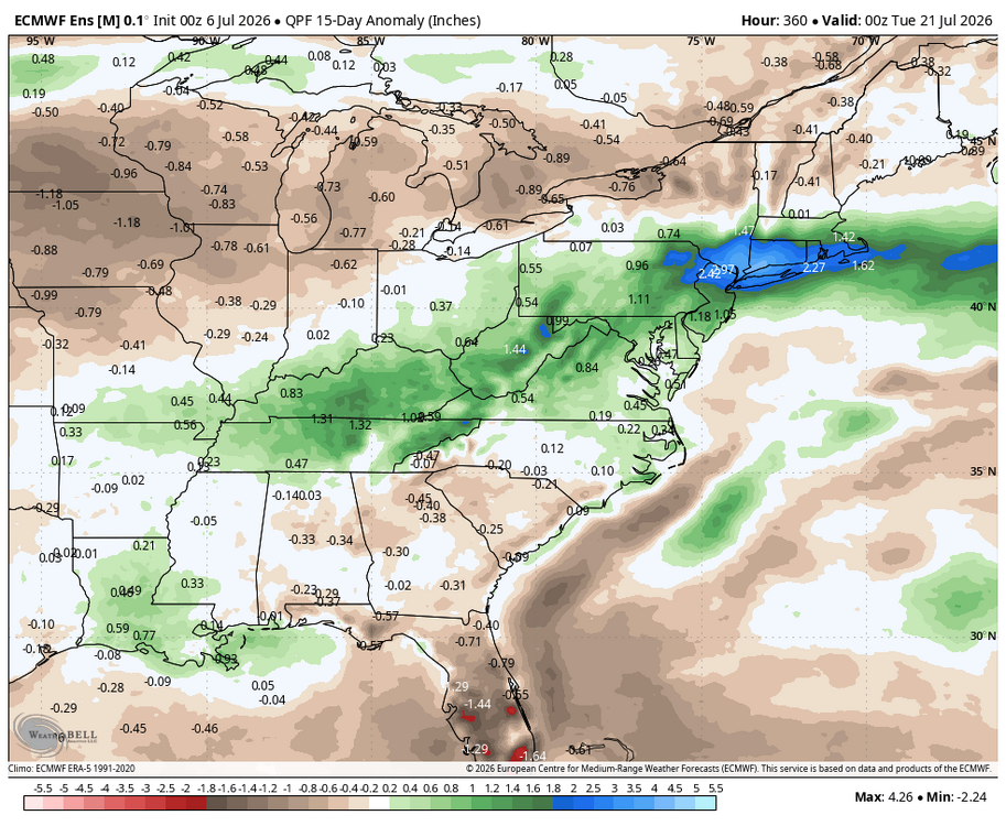
WB 0Z EPS is wet next two weeks.
-
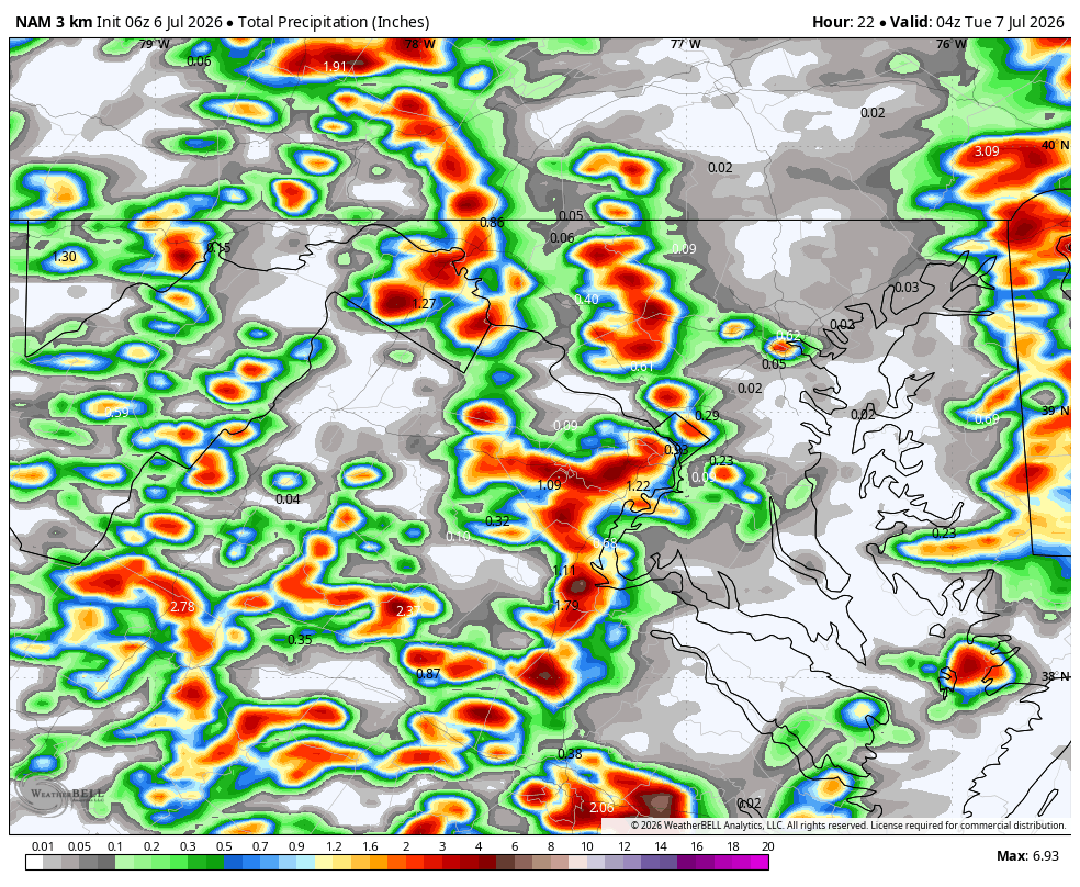
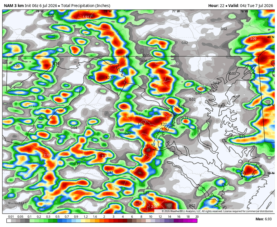
1.3 last night; best rain in forever....another round of storms later this afternoon/evening. WB 6Z 3K NAM.
-
Big Heat (and storms?) Week into July 4th Weekend
Weather Will replied to yoda's topic in Mid Atlantic
1.3 inches overnight. Hopefully more to come today. -
Big Heat (and storms?) Week into July 4th Weekend
Weather Will replied to yoda's topic in Mid Atlantic
Heavy downpours finally!!!! -
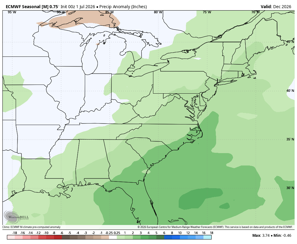
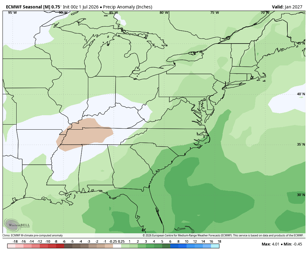
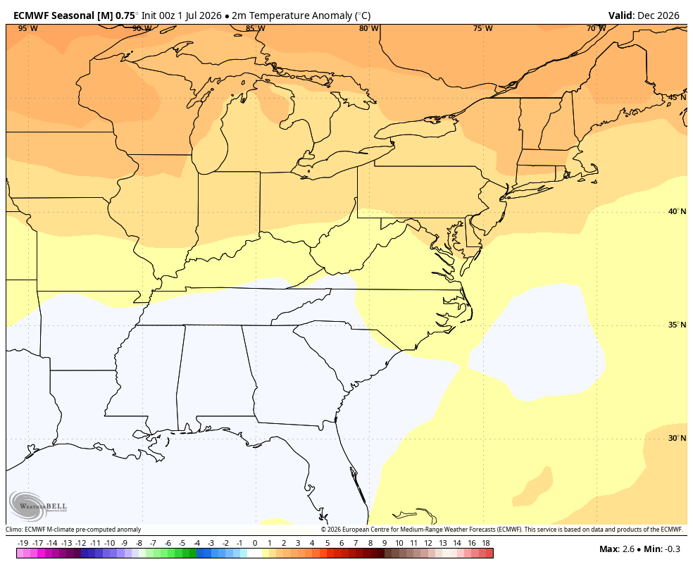
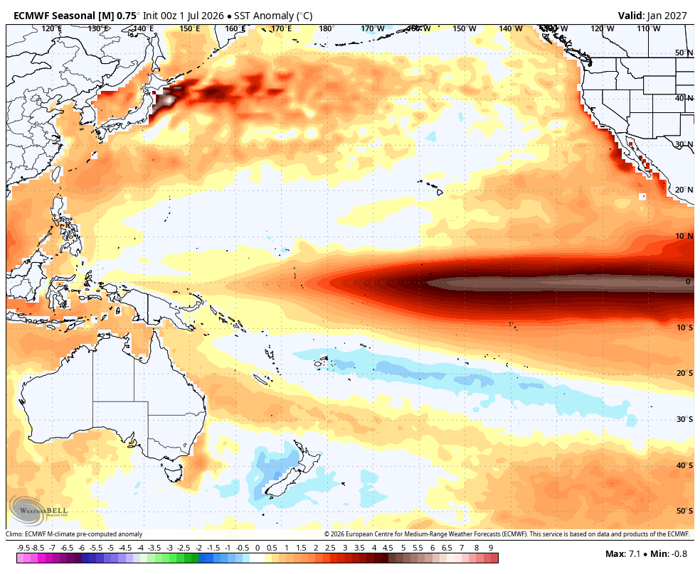
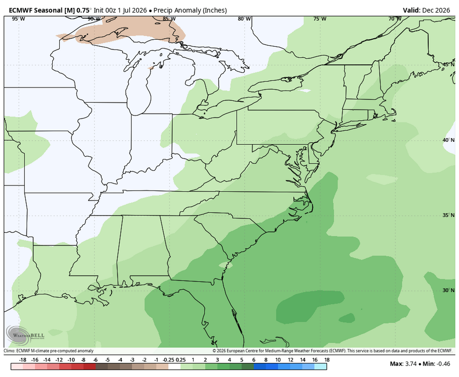
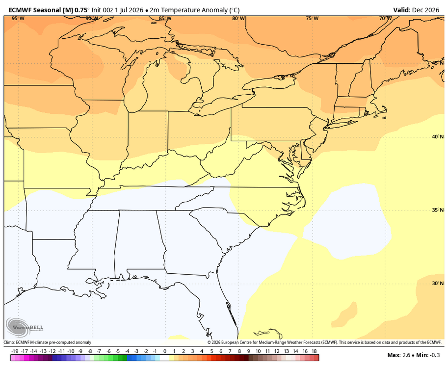
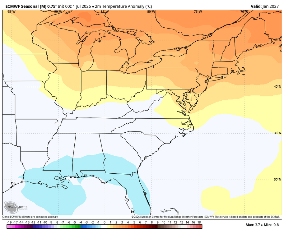
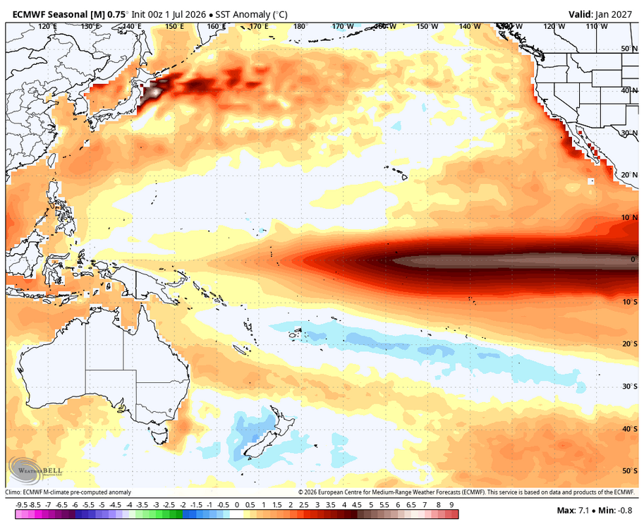
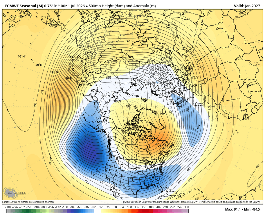
WB EURO latest seasonal through Jan. Maps: December and January temps and precip; Jan. Pacific Ocean temps, and Jan. upper air. Wet like the Canadian, but not as cold as the Canadian. It will be interesting to see how this trends over the upcoming months. We just need it cold enough to snow... One note: is encouraging not to see a SER this winter!

-
Big Heat (and storms?) Week into July 4th Weekend
Weather Will replied to yoda's topic in Mid Atlantic
WB 9Z HRRR pretty quiet today....
-
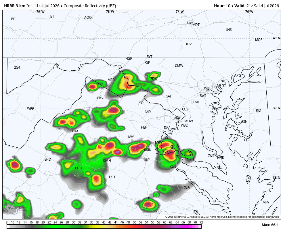
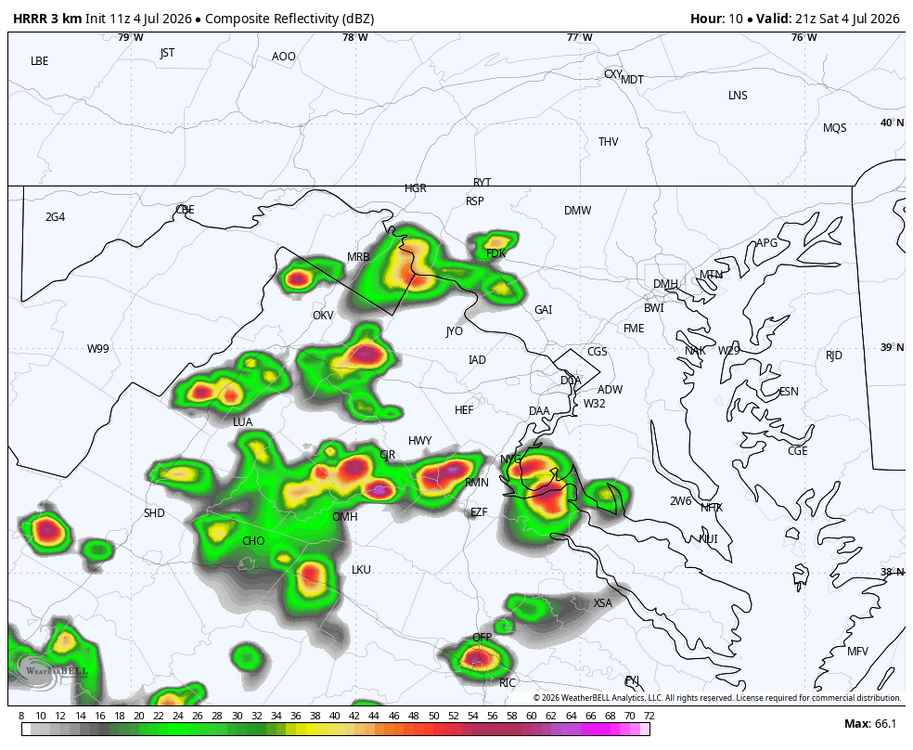
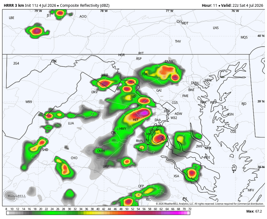
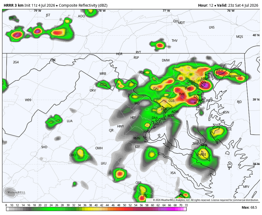
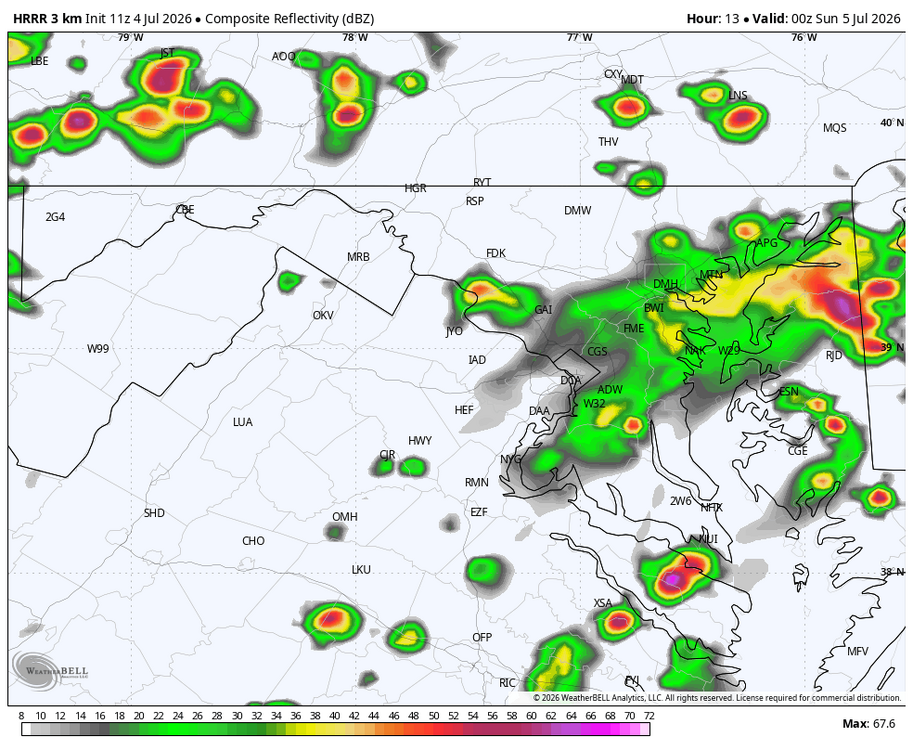
WB 11Z HRRR....thunderstorms move west to east starting around 5.
-
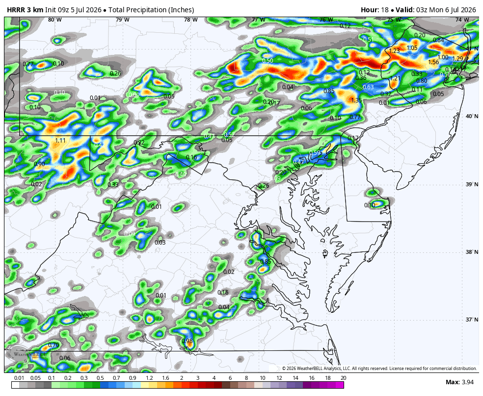
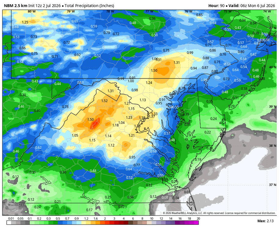
WB 6Z NBM Day 3 precip. Totals.

-
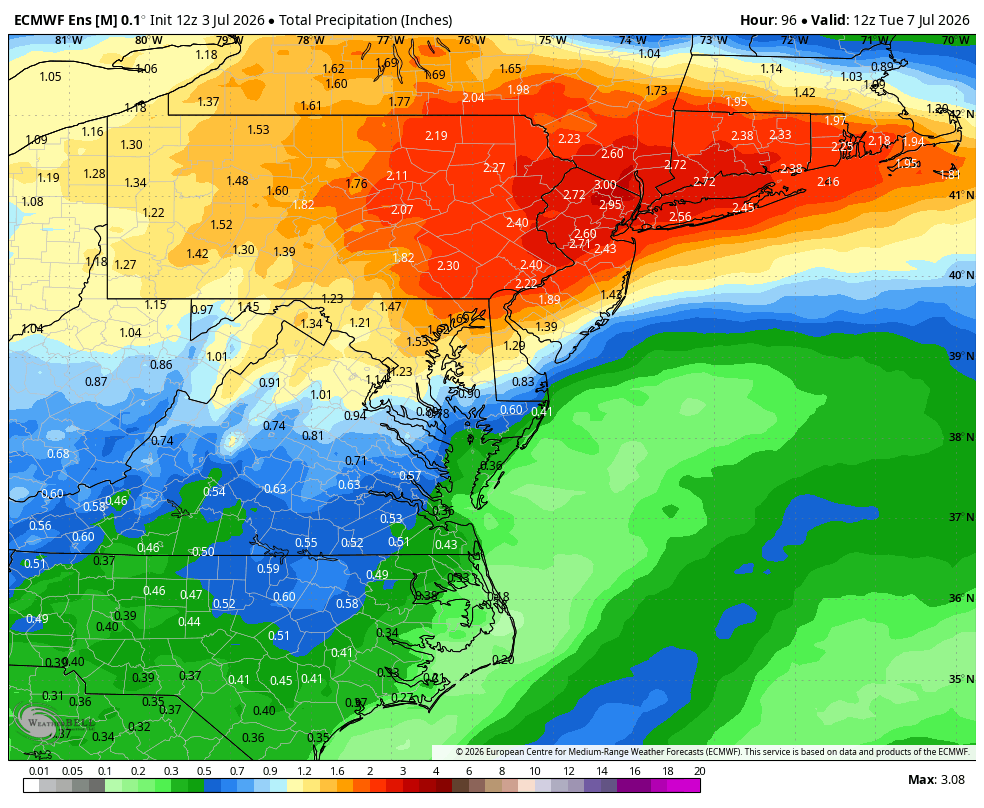
WB 12Z GFS, Can., and EURO ensemble precipitation through Day 4.


-
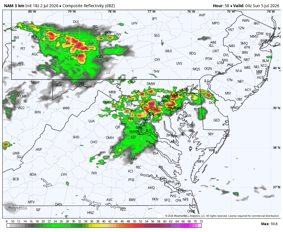
WB 18Z 3K NAM has thunderstorms by midnight on the 4th in DC.

-
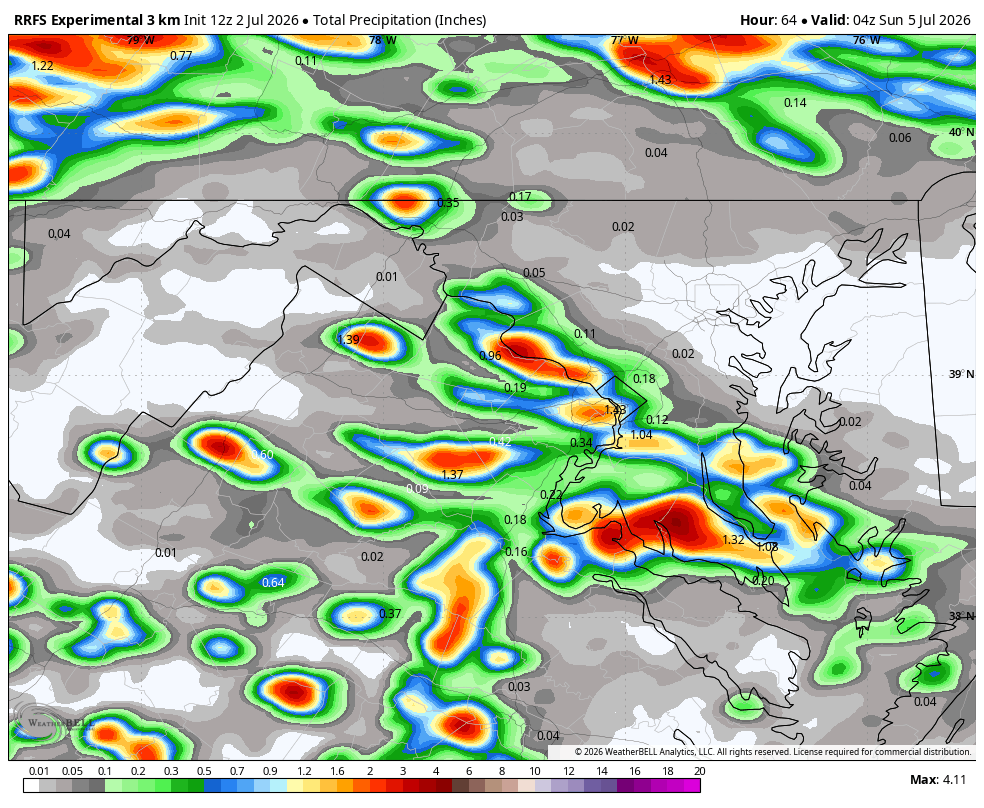
WB 12Z RRFS is forecasting some storms on the 4th.

-
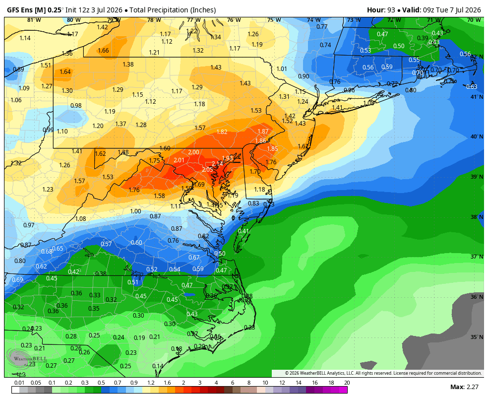
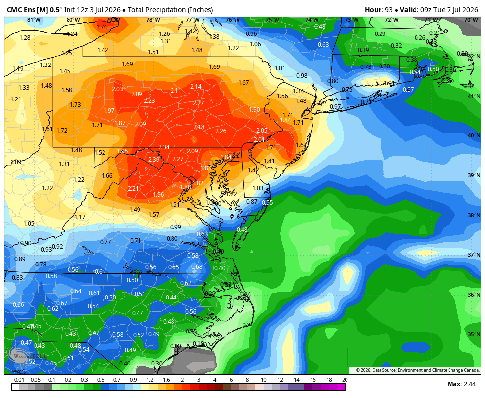
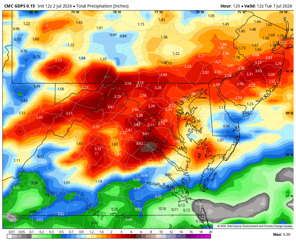
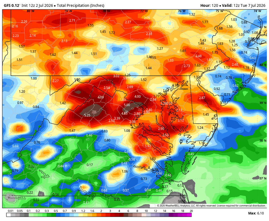
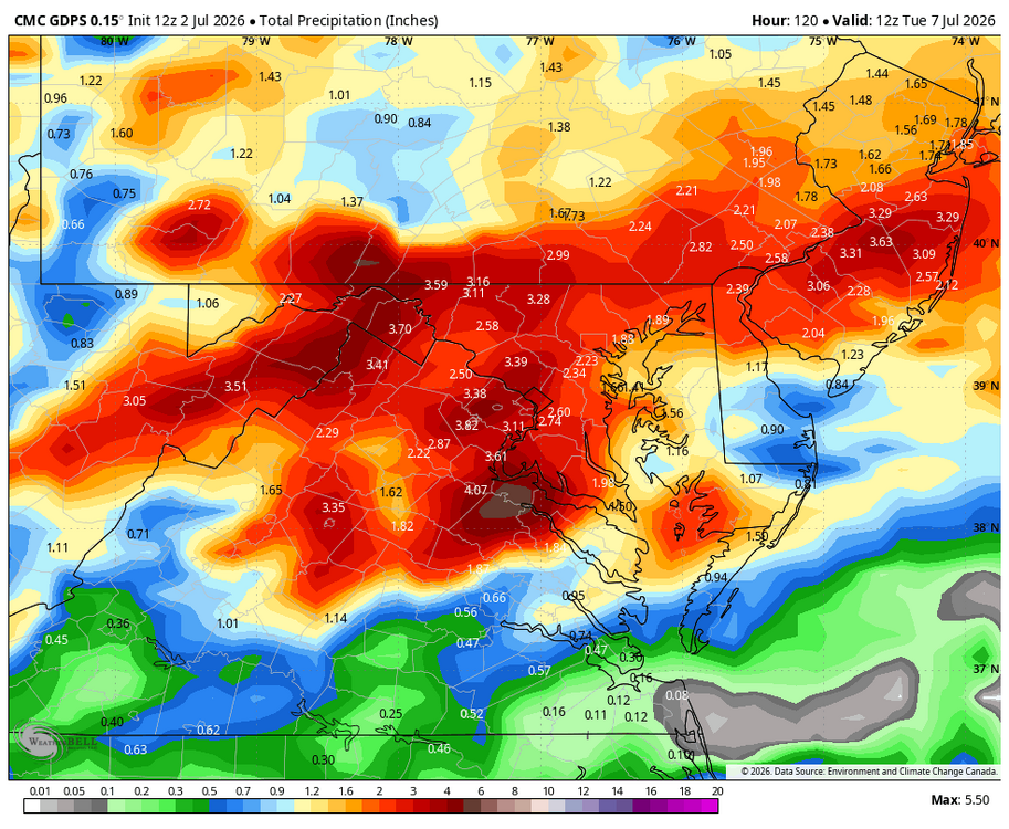
WB 12Z GFS and Canadian precip. through Day 5
-
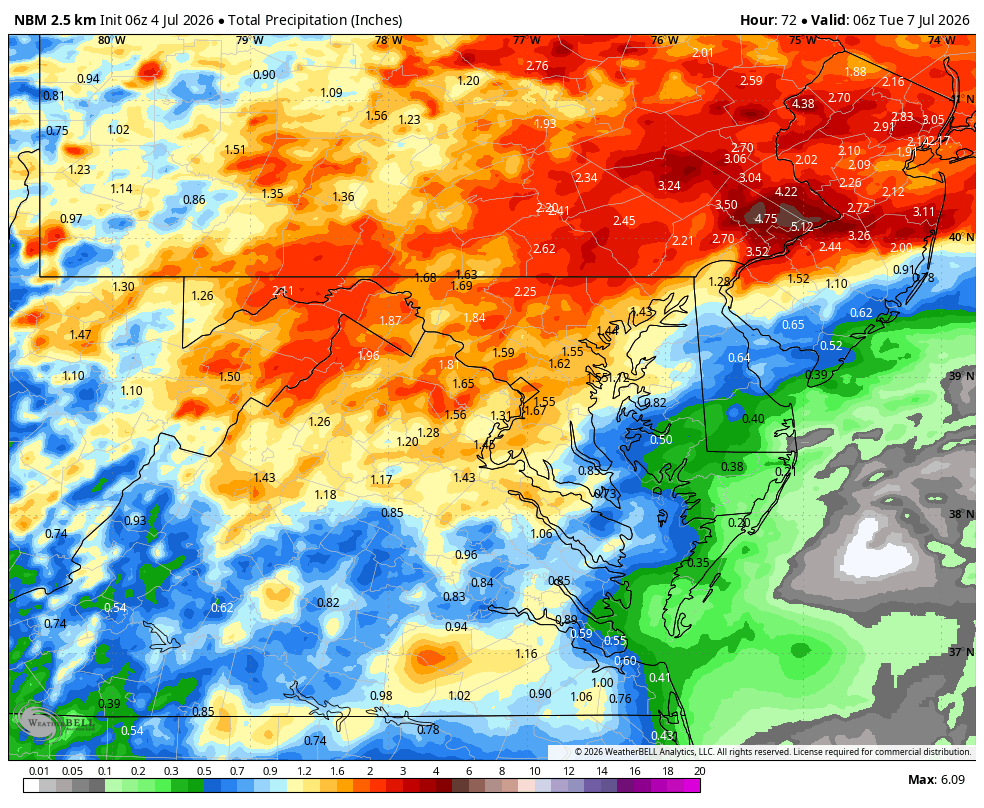
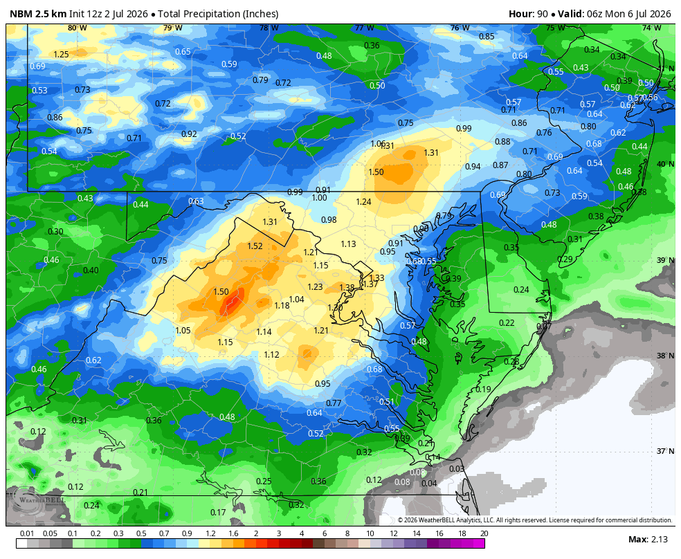
WB 12Z NBM through weekend. Most of this falls late Saturday/ Sunday.
-
Mod; please pin.