.jpeg.fb71a75fc71475b59e72598d4a9a6f88.jpeg)
TJW014
-
Posts
1,118 -
Joined
-
Last visited
Content Type
Profiles
Blogs
Forums
American Weather
Media Demo
Store
Gallery
Everything posted by TJW014
-
HRRRicane
-
And it's still snowing
-
You'll be fine. Even once it snows, it's going to take some time to cool the road surfaces enough for snow to stick. After 4 PM I'd stay off the roads. I have friends coming in from Sunday River (8.5 hour drive) They will be back by 4:30 tomorrow
-
I'm going to try and get into IBSP Monday (research purposes). I feel somewhere between there and Squan will be the bullseye. Matter of finding somewhere that doesn't have massive drifts
-
See, you understand! Haven't had a 10+ snow since 2018 (I wasn't here for Jan 2022)
-
98. 100 is SR-33
-
2-29 inches. What a spread lmao
-
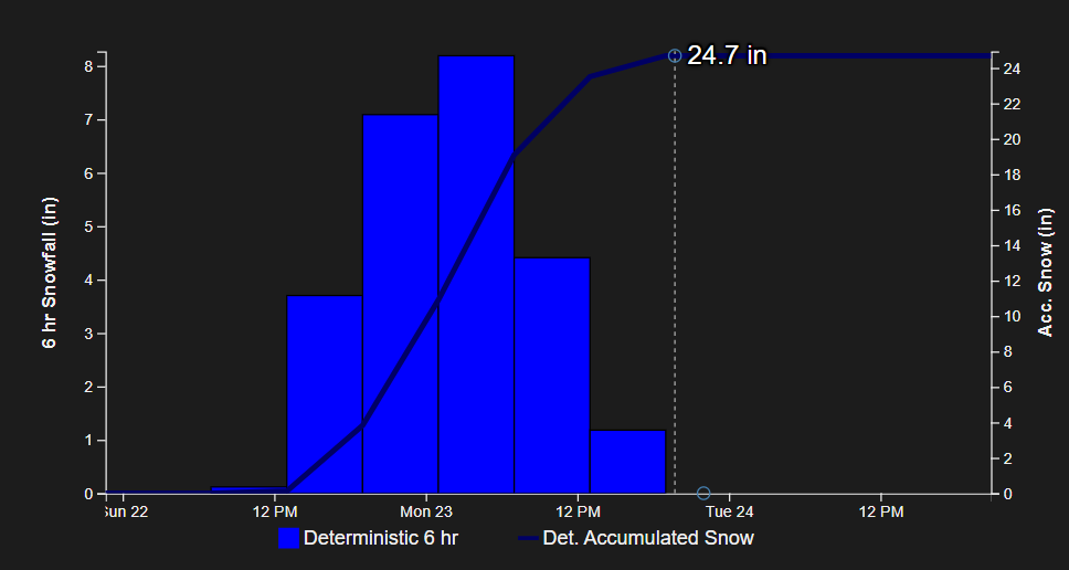
NBM is 28.1" of snow for here. Would be biggest storm since Boxing Day. Going with 18" for here.
-
Yeah, yeah, I'm using the NBM here, but these numbers are just incredible. Pretty awesome site: NBM 1D Viewer
-
There is not a single model showing less than 12" for me. Mean average is 20". That's incredible.
-
He'll have 20" in his backyard and still call it a successful forecast
-
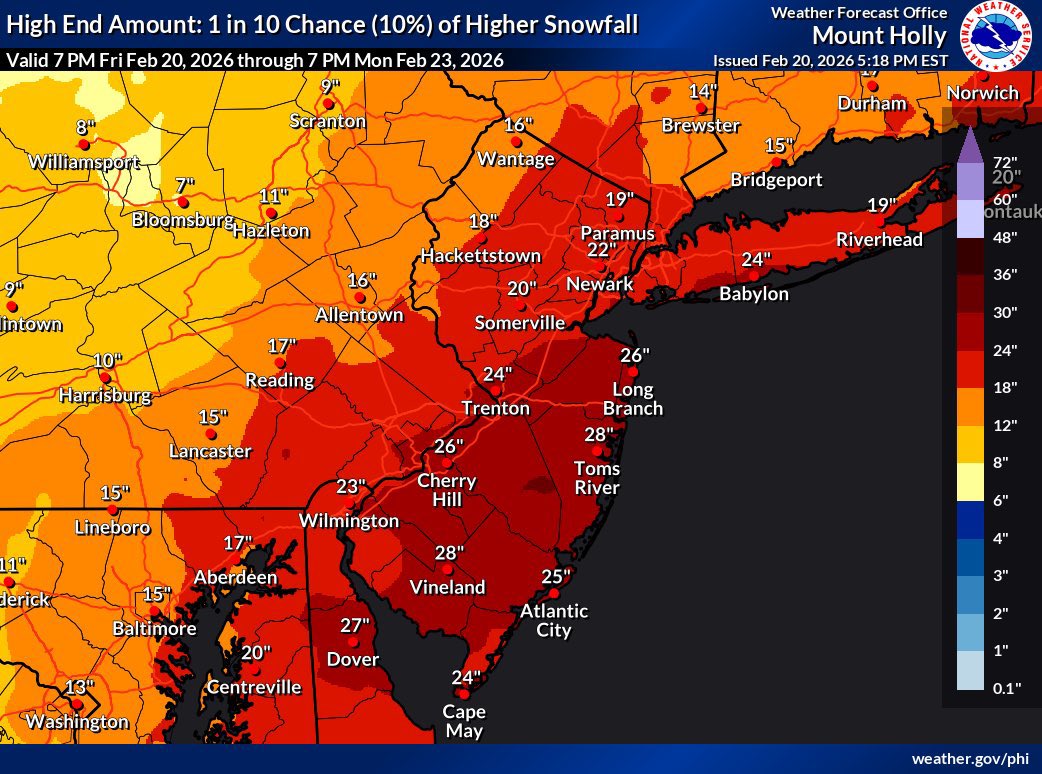
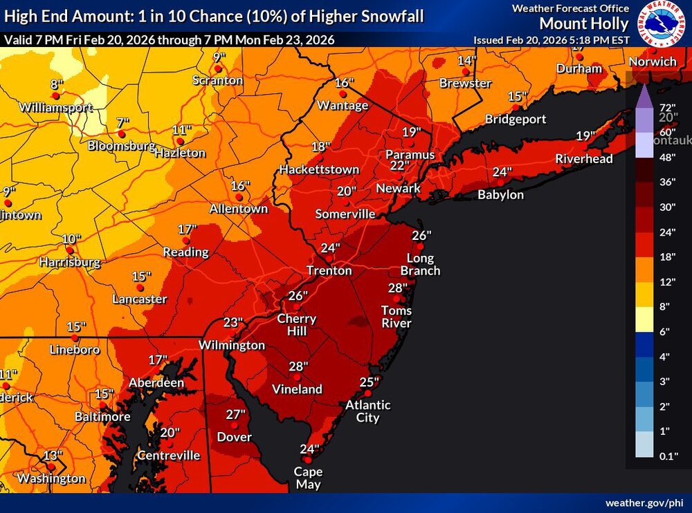
Mt Holly 1/10 chance maps. Haven't seen something like this in a LONG time
-
Hold on and love your significant other and kids like Mt Holly does to the NBM
-
WS Watch issued "Heavy Snow with total snow accumulations exceeding 6 inches possible. Winds could gust as high as 35 MPH" Conservative call for now.
-
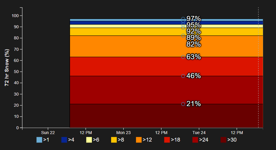
Still sucking on the NBM. waiting for 6" probs to reach over 50%
-
Kuchie shows less
-
MJO and WxGeek are going to blow their load
-
Same guy who said there was no storm threat two days ago. IMO something between GFS and Euro is a good bet.
-
I swear if this winds up being a rain storm I'd be more angry than if it whiffed, aside from putting a dent in the drought
-
60 hours till go time.
-
Still a lotta members to the west too.
-
Closer and I turn to rain.
-
I don't give a rat's ass about the NAM until tomorrow night
-
If 18z trends hold on with the 0z suite I'd say the odds for warning level snows increase significantly for NYC. Still, I'm cautious. We've had the rug pulled out beneath us before.
.thumb.jpeg.f5c6ba9d911ec96b3b124f8606aee58e.jpeg)