cptcatz
-
Posts
1,077 -
Joined
-
Last visited
Content Type
Profiles
Blogs
Forums
American Weather
Media Demo
Store
Gallery
Everything posted by cptcatz
-
2024 Atlantic Hurricane Season
cptcatz replied to Stormchaserchuck1's topic in Tropical Headquarters
Euro now has 94L becoming a hurricane in the caribbean... -
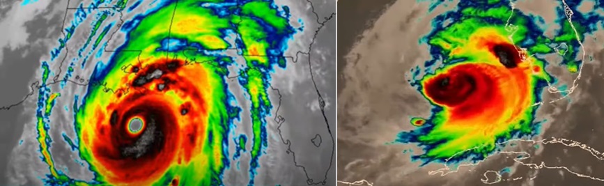
I think the problem with using Katrina as an example of "surge being baked in" is that Katrina was a massive category 5 that weakened IMMEDIATELY before landfall. Even though Katrina made landfall as a cat 3, it still made landfall with a central pressure of 920 mb, which is comparable to a cat 5. I mean look at these two satelite images... do you really think these would produce anywhere close to the same surges? I'm no professional meteorologist but I think the biggest factor for surge is the size of the storm. We clearly saw that with Sandy, Ian, Helene, Katrina, as opposed to tiny storms like Charley and Milton.
-
2024 Atlantic Hurricane Season
cptcatz replied to Stormchaserchuck1's topic in Tropical Headquarters
NHC really doesn't trust the GFS. GFS shows a tropical storm forming in 3-4 days and we can't even get a 20% confidence that a storm will form in 7 days from the NHC... -
2024 Atlantic Hurricane Season
cptcatz replied to Stormchaserchuck1's topic in Tropical Headquarters
18z GFS goes berserk with cyclogenesis in only 96 hours and a cat 4 in 174 hours. It sticks with burying it into Belize. This would be disastrous for that area with the rain and mudslides in addition to the hurricane winds. Kinda strange how GFS has a tropical storm in 4 days and no other models really have anything. It also has a weak storm forming from 94L in the caribbean. -
2024 Atlantic Hurricane Season
cptcatz replied to Stormchaserchuck1's topic in Tropical Headquarters
Looks like there are two different areas that models and ensembles are picking up on. First is the area of the western caribbean that the GFS and ensembles love to develop. Operational has shown it getting buried into central America but the ensembles show a bigger signal of bringing into the Gulf of mexico. Other models aren't as bullish but most others at least show CAG-like vorticity. The other area which seems to be getting more model support recently is the current 94L in the eastern Atlantic. Looks like it won't develop any time soon but all models seem to show it continuing as a healthy wave across the MDR and then possibly having it develop around the caribbean. Euro seems most bullish but this morning's GEFS shows some interesting scenarios as well. Hopefully we'll get a better picture of these in the next few days. Looks like this late peak season might continue into late October. -
2024 Atlantic Hurricane Season
cptcatz replied to Stormchaserchuck1's topic in Tropical Headquarters
Nice summary. You missed the crazy tornado outbreak yesterday. Palm Beach, Martin, and St. Lucie counties had one of their impactful weather days in history with the nonstop tornado warnings for legitimate large and long tracking Tornado Alley style tornadoes. Also, you think Helene will be the costliest on record? Surpassing Katrina? -
They already have. Significant damage in Fort Myers: https://x.com/theScantman/status/1844067282361930200
-
Large tornado observed in that cell https://x.com/NWSMiami/status/1844017578357993544
-
Yeah I mean they clearly missed it based on the lack of wind direction change. I just wonder why.
-
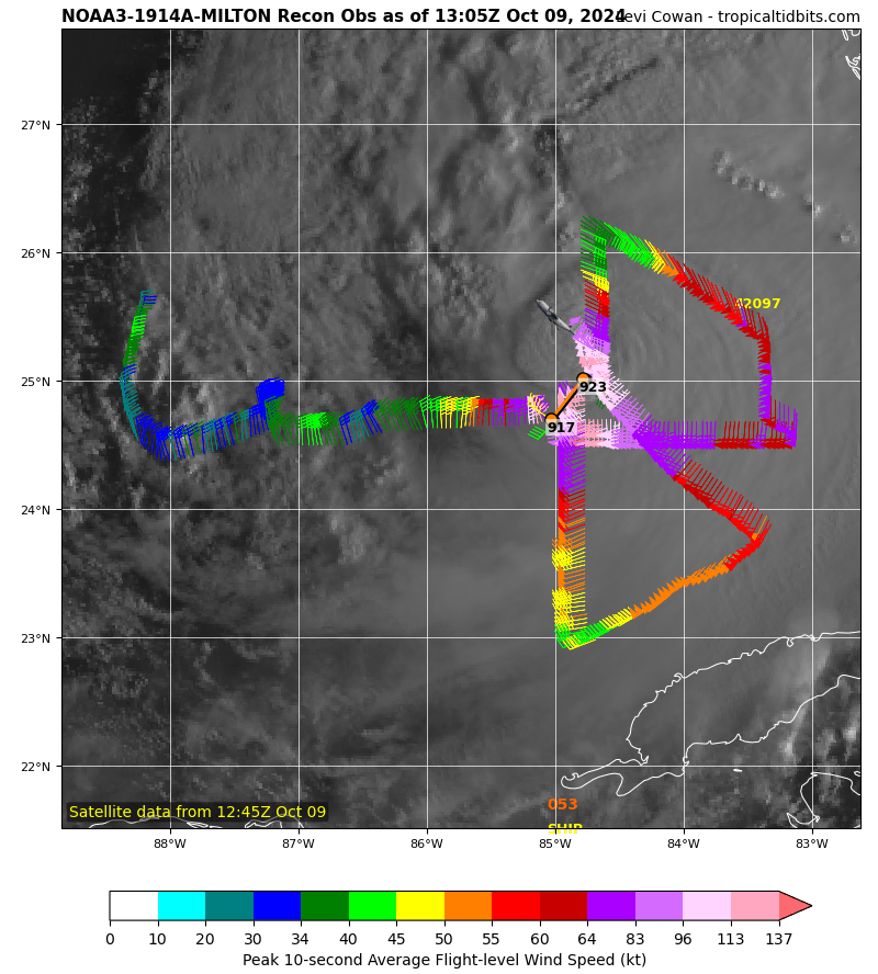
Did recon just clearly miss the center?

-
There's still a huge windfield to the southeast of the center which should still be expanding. Nothing is stopping the massive surge that will occur on the coast south of the landfall point.
-
Eyewall replacement cycle occurring. That inner eyewall still producing 154 kt wind while that secondary peak is already at 127 kt. Will be interesting to see how the storm structure changes.
-
2024 Atlantic Hurricane Season
cptcatz replied to Stormchaserchuck1's topic in Tropical Headquarters
Love going back to old posts. Kirk and Leslie had some nice attention but got kicked to the curb once Milton came around. -
That's an upper level dropsonde mission. Looks like an AF recon plane just took off, should be there in an hour or two.
-
Ok so maybe the eyewall misses the metro, but if it landfalls at Longboat Key where models show it today and then moves into South Bradenton, that puts the entire Tampa metro within about a 45 mile radius of the center. NHC says hurricane force winds extend out 30 miles right now and they explicitly said they expect the windfield to double in size. That puts all of Tampa metro in hurricane force winds. Not to mention that path takes it right over Orlando metro next. Surge aside, this is going to be a mess in those large populated areas.
-
One big difference is even if it does landfall around Sarasota and spares TB of the surge, the northern eyewall will still rake the sprawling Tampa metro of 3.2 million people with probably 100+ mph winds. While it may not be catastrophic damage, the widespread power outages and minor structural damage can add up quickly.
-
Looks like 06z Euro is trending a tad south around Sarasota and 06z GEFS has TB at the far northern end of the ensembles with a bunch betweeen Sarasota and Fort Myers. Wonder if this southern trend will continue.
-
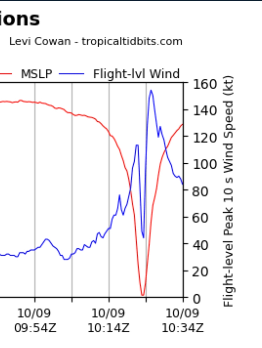
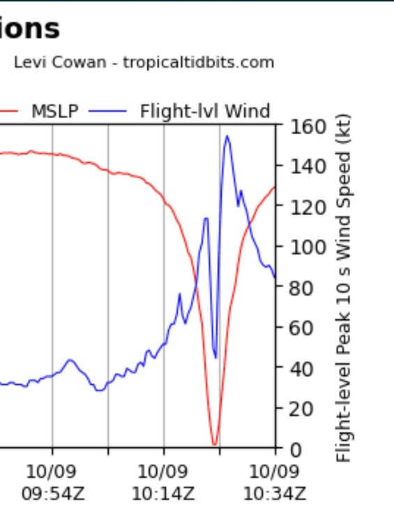
First pass: 926.7 mb, peak flight wind 126 knots
-
Recon recorded wind speeds really don't support an increase. These last two passes are actually a tad weaker than the first pass of the evening. Could be flattening out now.
-
Airliners are flying at 37,000 feet, well above the storm that far from the center.
-
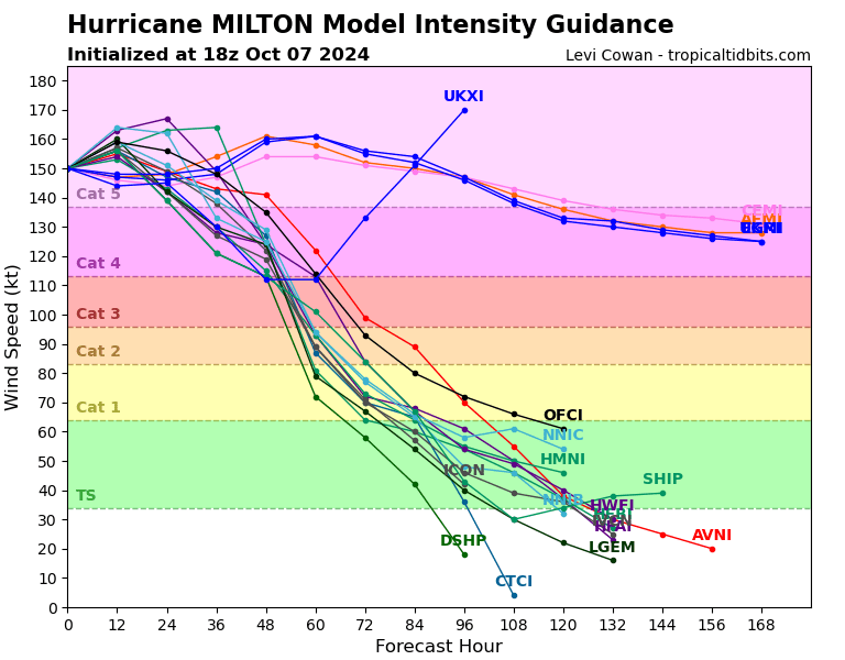
Interesting thing I just noticed. Assuming UKXI is drunk and not including that, there are still four models showing this staying as cat 5 for another 108 hours. Anyone know what those models are seeing that the others aren't?
-
The only thing that bothers me is when there are two planes in at the same time and then none for a few hours. Like why can't they stagger them?
-
Anyone know when the next plane takes off?
-
Unfortunately that's an upper level dropsonde mission. Will be good for forecast but not to get updated storm data.
-
Wow amazing recon data. Gotta think a NHC upgrade is imminent. Question is what will they put it as. 150 mph?