

cptcatz
-
Posts
1,033 -
Joined
-
Last visited
Content Type
Profiles
Blogs
Forums
American Weather
Media Demo
Store
Gallery
Posts posted by cptcatz
-
-
According to Tropical Tidbits this is now 91L.
-
 1
1
-
-
Strange though that none of the operational models really do much with this wave. They all keep it weak and into central America or it seems the GFS strings it out and splits it apart between the greater Antilles. One of the things I'm seeing with the models this year is they don't pick up on cyclogenesis until right before it happens which is what we saw with Ian.
-
1 hour ago, Jersey Andrew said:
Sadly agree with you. Good friends of mine barely escaped from Fort Myers Beach with their lives. Other friends and family are shaken. Look how Florida handled the Surfside condo collapse. Just pay off victims and families of the deceased so we can move on with business as usual. Have to keep the tourism merry go round going to fund the state.
I can see both sides of this. On the other hand, we saw after Andrew the building codes were vastly improved which has caused far less damage to occur in recent storms than what could have been. The outcome of Surfside was the state legislature passing new inspection requirements instead of the old 40 year requirement. What other outcome do you think would have been sufficient other than that and paying off the families? And regarding the developers, they only make money if people want to live where they build. Should the blame be on the developers or the people who choose to live on the coast? It's not like the residents aren't aware of the risks, they would just rather live near the water. Same can be said about small business owners like those stores and restaurants in Fort Myers Beach. People will always go to the beach and those business owners want to provide them services.
Honest question: what do you think a solution should be? Passing legislation prohibiting building a certain distance from the coast? I don't think only developers would be against that but all those other residents and business owners who want waterfront properties.
-
2
-
 1
1
-
-
06z GFS with a lot of members hitting SW Florida...

-
1
-
-
1 hour ago, Brian5671 said:
Recurve city that far out this time of year?
You'd think but the last two euro runs keep it low and quite a few GEFS members do as well...
-
1
-
-
Here we go again. All models seem to be petty bullish on this.

-
1
-
-
12z euro drops the pressure from 990 to 977 in the next 24 hours prior to landfall...
-
1
-
-
2 minutes ago, Baltimorewx said:
It was, wish the modeling would have held. I think some people got a sense of security when the track supposedly shifted north into the big bend area. Unfortately thats just how it goes with forecasting.
If they would have just thrown the GFS in the garbage where it belongs and went with king euro the entire time, it would have been perfect.
-
1
-
 2
2
-
 5
5
-
-
Looking ahead, models are in agreement that another AEW will be emerging in a couple days which will develop in the eastern Atlantic. Kinda surprised the NHC hasn't lemoned it yet since all models show it developing in less than 5 days. Euro and icon have it riding low, GFS and CMC have it quickly curving out.
Longer range, GFS is hinting at another Caribbean storm, bombing it out on the 06z run to 922 mb...
-
2
-
-
40 minutes ago, StormChaser4Life said:
Unfortunately once over land recon can't fly into Ian so they use satellite estimates and models that estimate weakening so is it perfect? No. Could Ian be weaker than this? Yes. But is it still a powerful and dangerous hurricane? Definitely. That nw eyewall is still pounding many cities with high end winds and extreme flooding rain.
I think what he's trying to say is that right now (as of 10pm), the NHC is saying that this storm is producing surface level sustained winds of 100 mph somewhere. You don't need recon planes or satellites or models to tell us that. The storm is well inland in a populated area. If the storm is actually producing 100 mph sustained winds, we would know. But it's not. So what is the NHC telling us? That if this same storm were over open water then it would be producing 100 mph winds? What good is that? Why not just use actual surface wind measurements to tell us what the storm is currently doing?
-
2
-
1
-
2
-
-
On 9/18/2022 at 6:54 PM, GaWx said:
There are a significant number (nearly 25%) of 12Z EPS members landfalling on the CONUS 9/29-10/2 as hurricanes or as a strong TS from TX through NC with also a couple of still offshore threats. At least half of these hit the FL Gulf coast, which is my #1 risk area this season based on third year cold ENSO analogs. Being that this was a more active EPS run than prior ones, I wouldn't be surprised if most of the next ones over the next few days aren't as active. Regardless, this will more than likely be the next potential threat period on the CONUS.
Good call
-
2
-
1
-
-
Pretty disappointing how dry and boring the eastern side of the storm system is. I was hoping to see a little more action here in Palm Beach County.
-
1
-
 1
1
-
 1
1
-
-
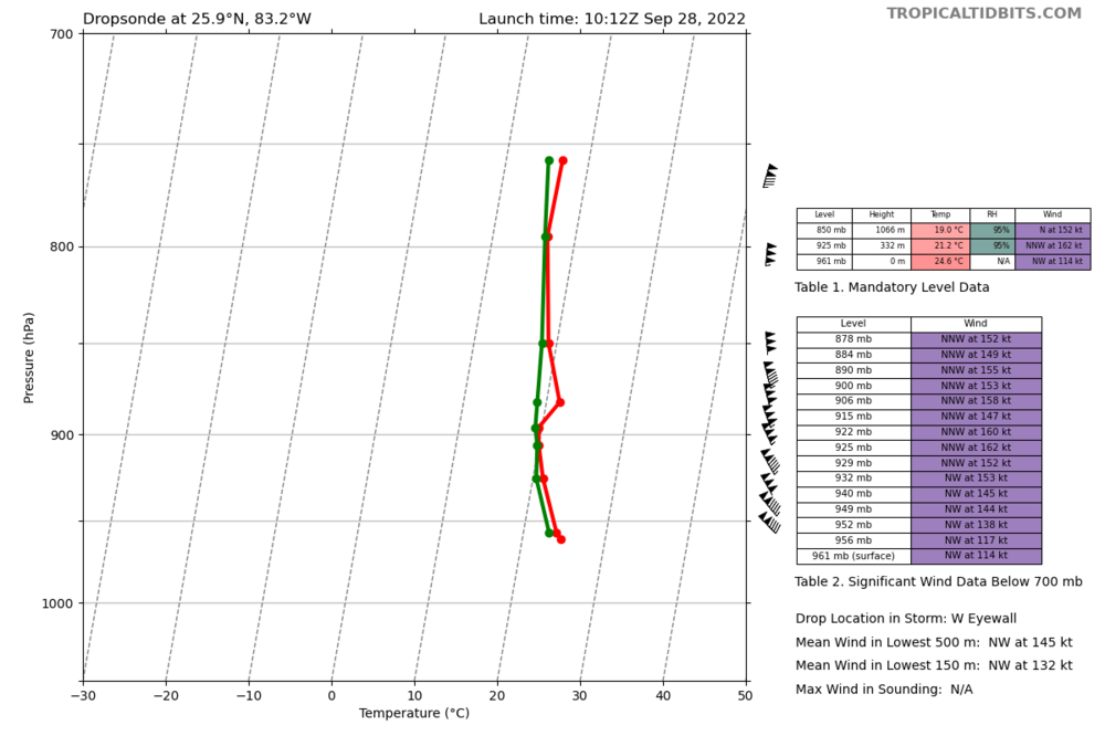
With this plane headed for the storm, can we do the intensity guessing game like we did for Eta back in 2020? That was the lolziest thing I've ever seen here. I'll start:
928 mb, 165 mph
-
933.1 mb in this pass
-
162 knot wind picked up on this dropsonde

-
1
-
1
-
-
3 minutes ago, Hotair said:
Lots of tornadic action from the outer bands crossing into South Florida. I don’t recall hearing of this high level of tornado activity either when Ian approached Caymans or Cuba. Does anyone know what seems to be more favorable in S FL that gives rise to tornado genesis?
This is just a total amateur guess but could be simply because of land area which allows us to know they are there. The islands are tiny compared to Florida so the odds of a tornado hitting one is very low. Maybe there were just as many tornadoes out in the water but we never knew since we had no radar or people to see them. If a tornado forms in the middle of the ocean and no one was around to see it, did it make a noise?
-
1
-
2
-
-
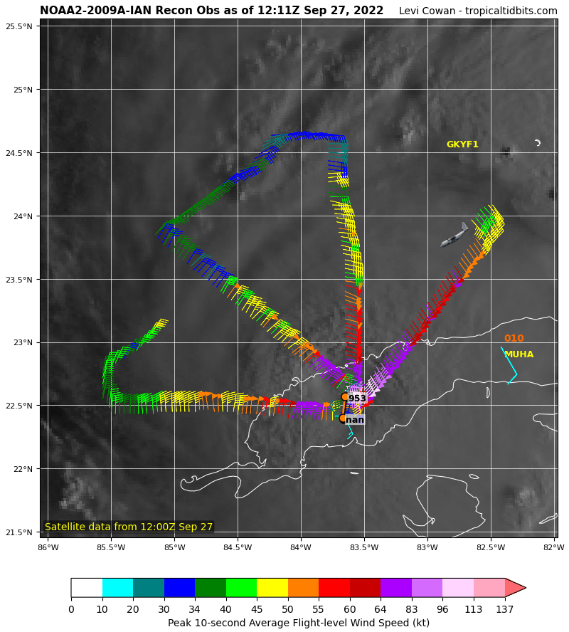
6 minutes ago, mob1 said:
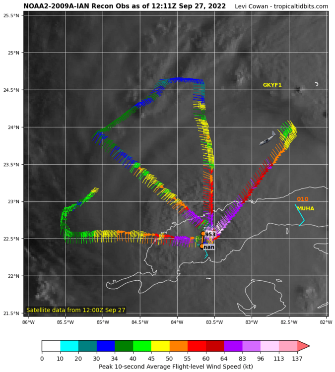
Pressure is quite a bit higher now as per recon, likely the EWRC doing a number on Ian (for the time being).
Recon just recorded 946 mb. Winds not impressive on this NW-SE fix but but should be higher in the NE.
-
10 minutes ago, jm1220 said:
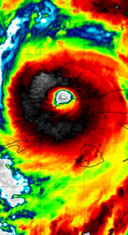
Extremely symmetrical/well defined eye. Just about picture perfect satellite presentation and definitely primed to go. Fort Myers looking like it’s in a really tough spot. I guess the one hope this doesn’t bring hurt on a lot of people is it somehow keeps trending south past Naples. That whole Tampa to Ft Myers area has exploded in population as others have pointed out, so there’s really no “good” landfall area in that stretch, and it’s also very surge vulnerable especially with a larger storm like this.
Landfalling south of Naples would bring devestating impacts to the east coast, exactly like Wilma did. Dade-Broward-Palm Beach is the most populated part of the state and the eye going through there would be nearly worst case scenario.
-
2
-
-
That's an amazing structure for having just crossed over Cuba. Do you think cat 5 is on the table?
-
1
-
5
-
-
3 minutes ago, SnowGoose69 said:
Someone from Tampa would know this but wouldn't a landfall just south be a problem for places like eastern coastal St Pete and Pinellas point be vulnerable as a E-NE fetch of 50 plus knots pushes water across the bay...obviously you would not be piling water in advance from the Gulf but I imagine a nasty 3-4 foot surge could still happen
Tampa Bay has an average depth of only 12 feet so there is relatively very little water to pile up compared to all the water that can be pushed the other way from the GOM.
-
1
-
-
Northern eyewall back over water.

-
3
-
-
Recon just did fix the center to be moving east of north although very slightly.
-
2
-
-
06z Euro making landfall at Sarasota/Bradenton and 24 hours later only getting to Lakeland which is only 50 miles away. Although this run initializes at 989 mb over Cuba so not sure if the wrong intensity would affect the track.

-
1
-
-
Did that plane fly through the eye over land? I thought they don't do that.


Julia | 85 mph 982 mb peak | EPAC Crossover #2
in Tropical Headquarters
Posted
18z GEFS backing way off. Strange system we have.