

cptcatz
-
Posts
1,032 -
Joined
-
Last visited
Content Type
Profiles
Blogs
Forums
American Weather
Media Demo
Store
Gallery
Posts posted by cptcatz
-
-
We've got like 4 straight days of GFS runs showing a storm forming next weekend in the Caribbean with no other model support. This will be a huge win or a huge fail for the GFS.
-
I'm just gonna use my non-scientific mind and say you guys are arguing over something that has very little to do with the overall season. Yeah, I am truly on the side of thinking that the SST has minimal impacts on the overall season. I've learned over the last handful of years that bigger atmospheric things matter so much more... dust, wind shear, stability, latitude of the african waves, etc. You can have burning hot ocean temps but if those other things aren't there, you're not gonna get hurricanes. I think we just look at SST because it's so easy to measure while those other things are not. But whether we're talking about average SST, just above average, or well above average, I don't think that matters as much as you guys think it does. Just my opinion...
-
 1
1
-
-
Just gonna chime in to this conversation and point out that talking about the number of named storms is kinda stupid when discussing hurricane season in terms of both impacts to the general public and interest to us for tracking purposes. It's like when a tree falls in the forest and no one's around. Does anyone really care about a weak tropical storm that never makes landfall? Take 2017 for example... it had 17 named storms, higher than average but nothing too crazy, yet it was the most impactful year on record and had some of the most interesting storms ever to track (looking at you Irma). Then you have 2020 which had 30 storms and even though it was impactful because basically every hurricane hit land, it still didn't even crack the top 10 ACE seasons. Just seems a little futile to be arguing about the number of named storms.
-
 1
1
-
-
Seems like modeling at this point is pointless. We know it's gonna head west towards the Honduras coast. Whether it hangs out just off shore or just on shore will make all the difference with the rest of the track, and I don't think there's any way to know for sure until it gets there. It's kinda pointless to say GFS shows nada (after getting shredded by the Honduras mountains) or Euro shows a hurricane in Florida (after barely staying off shore), since those scenarios are entirely dependent on the miniscule track errors of land interaction.
-
1
-
-
So 2024 already has the earliest cat 5 on record. Anyone know what the latest cat 5 is of now?
Edit: nevermind, it was easy to look up. There's only been one cat 5 ever in November on record. 1932 Cuba hurricane was a cat 5 on November 6. So this could break that record if it does reach that intensity.
-
1
-
 1
1
-
-
10 minutes ago, CCHurricane said:
All things equal, 12Z EURO also showing southern FL landfall, albeit in a much better location and with a weaker system.
Southern FL is mostly Wildlife Area vs. property development further North, yet this thing will be ripping from west to east in terms of forward momentum.

If that were to verify it would still bring a 980 mb eye over downtown Miami. That would cause quite a mess.
-
GFS isn't on an island with this next possible one. Today's 12z CMC shows a banafide storm and EPS shows a solid signal.
-
Recon just got 956 mb. Waiting for that new east side winds. Thinking cat 3 after it makes the pass.
-
1
-
1
-
-
Crazy lack of certainty with this system. Looks like it's between either getting strung out and heading straight northeast through the Greater Antilles and out to sea, or it moves northwest through the Caribbean, into the GoM, and then cuts back across Florida. GFS has been showing the strung out northeast, GEFS seems to have a lot of members going into the GoM, Euro shows just a broad gyre, while many EPS members also show going into the GoM. Looks like Canadian and its ensembles also support the GoM track. Quite a significant difference in tracks with an already battered Florida in the path of one of them.
-
1 hour ago, NorthHillsWx said:
It looks like a tropical depression to me. It’s been generating organized convection over a tight LLC overnight and into this morning
I agree with NHC in that convection is not organized. Looks to be puffing some convection which then fades away and then puffs another.
-
Euro now has 94L becoming a hurricane in the caribbean...
-
1
-
-
On 10/10/2024 at 1:15 PM, Pityflakes said:
This.
Can we please shelve the "surge is baked in because it used to be a Cat 5" myth. Which as far as I can tell isn't based on anything other than people invoking Katrina. Seems like surge is actually way more complicated and difficult to predict, but appears much more sensitive to topography, fetch, wind direction and duration, etc. Wind speed of course matters (an actual 140/150 mph cane at landfall is going to push a lot of water, but those extreme impacts are localized to the actual eye wall), but "historical" wind speed/pressure of a storm is less relevant.
ETA: I'm not downplaying the impact of Milton or suggesting it was a "bust" somehow. But rather I'm suggesting that the surge impacts played out exactly like one would expect from a robust Cat 2/3 given approach angle and topography.
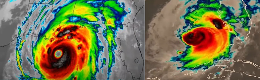
I think the problem with using Katrina as an example of "surge being baked in" is that Katrina was a massive category 5 that weakened IMMEDIATELY before landfall. Even though Katrina made landfall as a cat 3, it still made landfall with a central pressure of 920 mb, which is comparable to a cat 5. I mean look at these two satelite images... do you really think these would produce anywhere close to the same surges?
I'm no professional meteorologist but I think the biggest factor for surge is the size of the storm. We clearly saw that with Sandy, Ian, Helene, Katrina, as opposed to tiny storms like Charley and Milton.
-
4
-
 1
1
-
1
-
-
NHC really doesn't trust the GFS. GFS shows a tropical storm forming in 3-4 days and we can't even get a 20% confidence that a storm will form in 7 days from the NHC...
-
1
-
-
18z GFS goes berserk with cyclogenesis in only 96 hours and a cat 4 in 174 hours. It sticks with burying it into Belize. This would be disastrous for that area with the rain and mudslides in addition to the hurricane winds. Kinda strange how GFS has a tropical storm in 4 days and no other models really have anything. It also has a weak storm forming from 94L in the caribbean.
-
1
-
-
Looks like there are two different areas that models and ensembles are picking up on. First is the area of the western caribbean that the GFS and ensembles love to develop. Operational has shown it getting buried into central America but the ensembles show a bigger signal of bringing into the Gulf of mexico. Other models aren't as bullish but most others at least show CAG-like vorticity.
The other area which seems to be getting more model support recently is the current 94L in the eastern Atlantic. Looks like it won't develop any time soon but all models seem to show it continuing as a healthy wave across the MDR and then possibly having it develop around the caribbean. Euro seems most bullish but this morning's GEFS shows some interesting scenarios as well.
Hopefully we'll get a better picture of these in the next few days. Looks like this late peak season might continue into late October.
-
2
-
1
-
-
2 hours ago, Windspeed said:
ACE will be over 140 points heading into the second weekend of October. It's quite obvious now that if the Atlantic Basin had produced only a few hurricanes during the stretch of prolonged and below normal intraseasonal quiet, we would we would finish at hyperactive values. Granted, a hyperactive season is still possible given a few strong Carribean hurricanes through November, and we have seen activity into November in recent years. However, it is more likely we will not hit the lofty preseason targets. We are, however, going to finish above normal.
The ACE metric and total number of named storms do not necessarily weigh on how bad the season has been. The CONUS has experienced a nightmarish tropical cyclone season with five landfalling hurricanes. Six is the record (2020, 1985, and 1886). However, 2024 landfalls have been deadly and expensive. After Beryl devestated the Grenadines and impacted Jamaica and the Yucatán, it went on to produce notable damage in the Houston-Galveston metropolitan region. Francine caused significant flood damage in the western New Orleans metro. Helene, not withstanding significant surge impacts from Tampa to Steinhatchee, was among the worst inland wind and flooding TCs in American history and will no doubt prove to be the costliest TC on record because of it. Helene will also end up among the deadliest for the US due to the catastrophic events that unfolded in the southern Appalachians. Though Milton can be considered a very lucky impact, barely missing Tampa Bay to the south and avoiding a catastrophic landfall, it was still a powerful system that flooded coastal shoreline communities and has wreaked havoc inland across the peninsula with damaging winds in the Tampa, Pete and Sarasota metros; furthermore, inflicting significant damage to inland trees and power grid infrastructure, plus significant inland fresh water flooding. Estimates for the 2024 season's price tag may push a quarter of a trillion dollars and go down as the costliest season in US history.Nice summary. You missed the crazy tornado outbreak yesterday. Palm Beach, Martin, and St. Lucie counties had one of their impactful weather days in history with the nonstop tornado warnings for legitimate large and long tracking Tornado Alley style tornadoes.
Also, you think Helene will be the costliest on record? Surpassing Katrina?
-
1
-
1
-
-
1 minute ago, beanskip said:
No way all these tornadoes are going to be able to avoid high population areas forever. What a remarkable outbreak.
They already have. Significant damage in Fort Myers:
-
2
-
 1
1
-
-
8 minutes ago, nwohweather said:
These are some very healthy supercells with solid hooks over Alligator Alley.
Large tornado observed in that cell
-
1
-
2
-
-
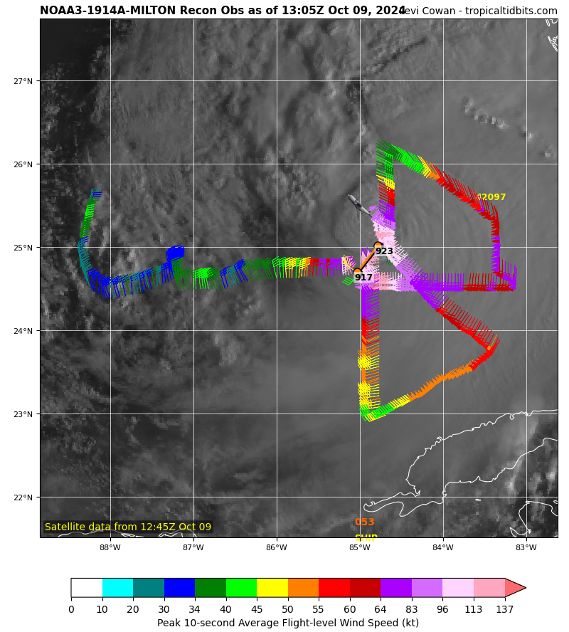
1 minute ago, AccuChris said:
I was wondering the same as the lowest pressure they found was 941mb. So either they totally missed it or the pressure rose 20mb in an hour
.Yeah I mean they clearly missed it based on the lack of wind direction change. I just wonder why.
-
Did recon just clearly miss the center?

-
2 minutes ago, NorthHillsWx said:
Shear is finally hitting. That’s not just ERC. That’s a full erosion of the western circulation. Thank the lord this is still a tight circulation. Will mitigate surge somewhat.
There's still a huge windfield to the southeast of the center which should still be expanding. Nothing is stopping the massive surge that will occur on the coast south of the landfall point.
-
1
-
-
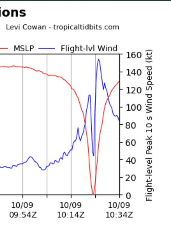
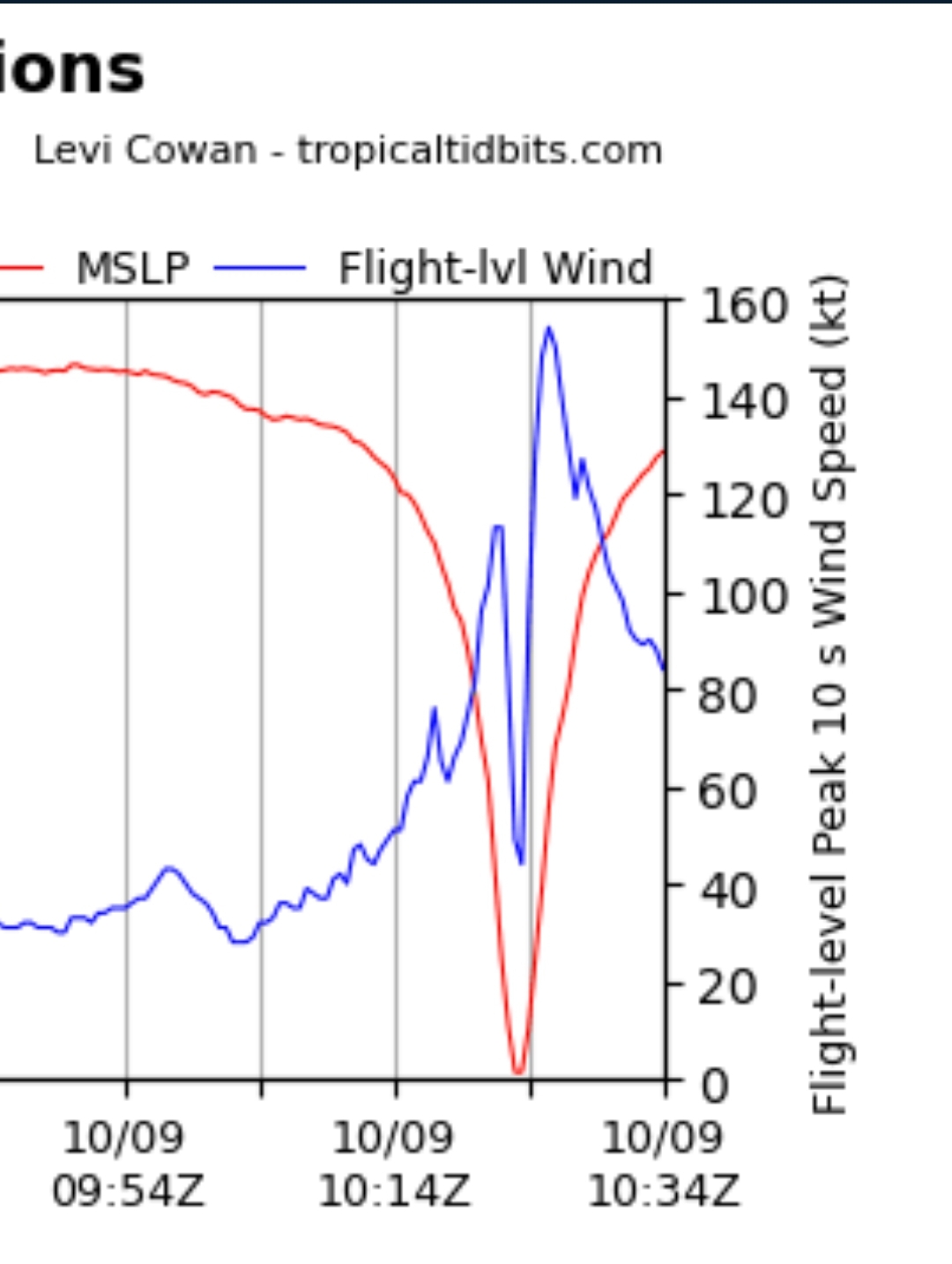
Eyewall replacement cycle occurring. That inner eyewall still producing 154 kt wind while that secondary peak is already at 127 kt. Will be interesting to see how the storm structure changes.
-
On 10/1/2024 at 11:04 AM, cptcatz said:
Looking likely that there will be two concurrent major hurricanes (Kirk and the next one right on its heels) in the central Atlantic on the first week of October. Pretty logical to have 5x ACE given that situation this time of year. Let's see what happens with this Gulf system though...
Love going back to old posts. Kirk and Leslie had some nice attention but got kicked to the curb once Milton came around.
-
1
-
-
1 minute ago, NJwx85 said:
The plane just got there.
That's an upper level dropsonde mission. Looks like an AF recon plane just took off, should be there in an hour or two.
-
1
-
1
-

Invest 92L--70% Two Day & 70% Seven Day Odds
in Tropical Headquarters
Posted
Impressive area of convection formed this morning. This looks a lot more like a tropical storm than most other early season slop I've seen. If it holds up it can easily overperform the models.