

cptcatz
-
Posts
875 -
Joined
-
Last visited
Content Type
Profiles
Blogs
Forums
American Weather
Media Demo
Store
Gallery
Posts posted by cptcatz
-
-
10 minutes ago, NJsnow89 said:
Going to be in Orlando Wednesday and Thursday. Will there be any issues there?
I think it's a given that Wednesday and Thursday will be a washout at the very least. There could definitely be bigger issues if this thing is on the stronger side of the models...
-
^I suppose a 977mb storm would be the worst case scenario for a mid-November sloppy subtropical system...
Anyways, the ensembles are just as bullish as the GFS operational.
-
8 minutes ago, olafminesaw said:
It's pretty simple really...the GFS is on crack. A fairly weak low tracking across Florida, into the gulf, bringing areas of heavy rain, makes the most sense.
All year GFS and Euro have been meeting half way. Now with GFS showing 982mb and Euro showing 1006mb, mark my words here that it will be 994mb.
-
All models are in good agreement of some kind of sloppy system heading west over the Bahamas and into Florida next week. GFS with a 991mb into Jacksonville.
-
 1
1
-
-
So I'm counting like 8 tropical storms on the 06z GFS?
-
 1
1
-
-
Although euro doesn't show anything, EPS is as bullish it's been with this afternoon's run. There's a few really strong ones in there...

-
I want to believe this could happen but after the shenanigans the GFS has played before in the Caribbean this season, I'm not gonna get on board until there's other model agreement. Icon is on board but I'll need more than just that.
-
3
-
-
06z still moving up in time with a 990mb at h156, 966mb at h180, and 939mb at h216. 12z ICON is on board but not much else.
-
Looks like the season is winding down. Not looking like a backloaded season. I think we can officially call it a forecast bust.
-
1 hour ago, bigtenfan said:
That map is for tropical storm winds and depending on the exact detail shows the landfall area at a 50 to 80 percent chance of TS winds
I am sure that the 50 and 64 kt wind maps showed even a lesser chance
I am sure that map was based on the GFS which failed miserably in this storm at the cost of many many lives
I'm saying that the NHC should replace the cone graphic with a SIMILAR graphic to this one which shows the probability of significant impacts (whether it be wind, rain, or storm surge) based on colors. And it doesn't have to be uniform. It can be skewed to show the heavy surge impacts on the south side of the system and heavy rain impacts on the north side like Ian had. But one graphic showing likelihood of impacts would be far more useful than a cone showing where the center might go.
-
1 hour ago, GaWx said:
With 91L (along with possibly 92L) being an increased threat to form and considering that 5 TCs formed after the peak date of the season climowise (Sept 14th+) resulting in one of the most active 2nd halves of September on record, this is already highly debatable imho. What exactly is meant by a backloaded season?
I see the entire month of September as peak season. I'm pretty sure that every September in the history of hurricane tracking has been "active". I see an active July and August as front loaded and an active October and November as backloaded. Fiona and Ian occurred during peak season and I wouldn't consider those being included in a backloaded season.
-
1
-
 1
1
-
-
1 hour ago, TPAwx said:
No threat to the US as this eventually goes into Central America, if it develops.
Not a certainty, see 2020 hurricane Eta.
-
1
-
 2
2
-
-
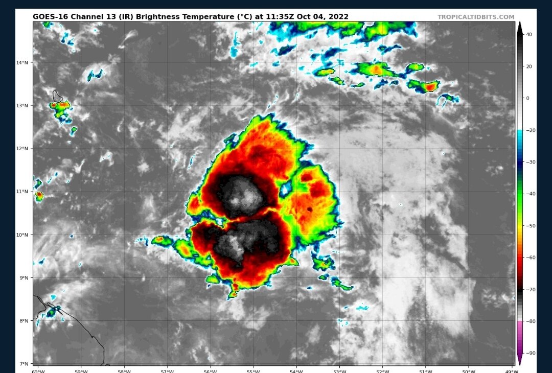
Solid convection this morning

-
1
-
-
13 hours ago, jacindc said:
I'm sure that some graphic artists could come up with a way to shade around the cone to show the potential breadth of impacts. (Which would then perhaps have shown more clearly a larger impact to the southeast of a land falling hurricane.) I know they do more now with surge forecasts, etc., and they repeat "don't focus just on the cone," but it's pretty clear that that's not good enough. They need a one-glance representation of potential level of impacts based on possible forecast deviations.
(And no, not with a Sharpie!)NHC puts out the wind probability maps which is the type of graphic they should be using for the entire storm. Move away from the cone and stick with a color coded graphic like this but for all impacts, not just wind.

-
2
-
1
-
-
The problem is the media these days sensationalizes everything and goes nuts when a tropical storm or weak hurricane hits. People then think "oh that's all that happens during a hurricane" not realizing the difference between a cat 1 and cat 4/5 hurricane. Then when a cat 4/5 is approaching they brush it off. The media is the one playing the boy who cried wolf game.
-
1
-
3
-
-
We're getting to a point where this so called backloaded season may not happen either.
-
 3
3
-
-
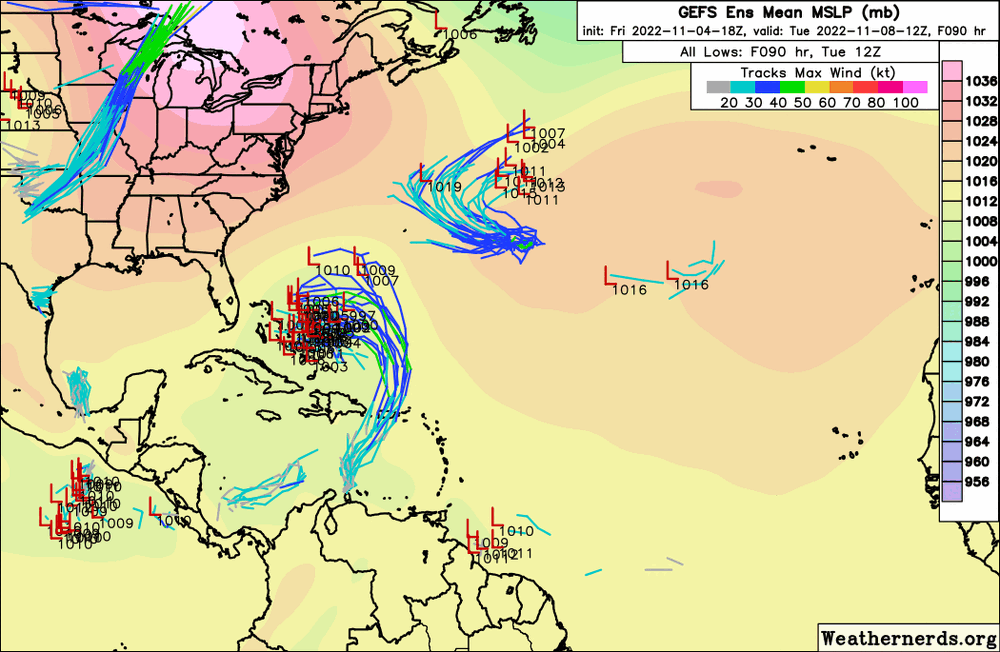
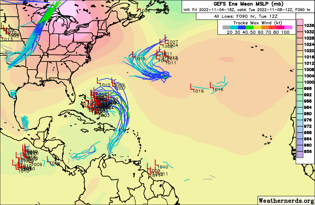
18z GEFS backing way off. Strange system we have.
-
According to Tropical Tidbits this is now 91L.
-
1
-
-
Strange though that none of the operational models really do much with this wave. They all keep it weak and into central America or it seems the GFS strings it out and splits it apart between the greater Antilles. One of the things I'm seeing with the models this year is they don't pick up on cyclogenesis until right before it happens which is what we saw with Ian.
-
1 hour ago, Jersey Andrew said:
Sadly agree with you. Good friends of mine barely escaped from Fort Myers Beach with their lives. Other friends and family are shaken. Look how Florida handled the Surfside condo collapse. Just pay off victims and families of the deceased so we can move on with business as usual. Have to keep the tourism merry go round going to fund the state.
I can see both sides of this. On the other hand, we saw after Andrew the building codes were vastly improved which has caused far less damage to occur in recent storms than what could have been. The outcome of Surfside was the state legislature passing new inspection requirements instead of the old 40 year requirement. What other outcome do you think would have been sufficient other than that and paying off the families? And regarding the developers, they only make money if people want to live where they build. Should the blame be on the developers or the people who choose to live on the coast? It's not like the residents aren't aware of the risks, they would just rather live near the water. Same can be said about small business owners like those stores and restaurants in Fort Myers Beach. People will always go to the beach and those business owners want to provide them services.
Honest question: what do you think a solution should be? Passing legislation prohibiting building a certain distance from the coast? I don't think only developers would be against that but all those other residents and business owners who want waterfront properties.
-
2
-
1
-
-
06z GFS with a lot of members hitting SW Florida...

-
1
-
-
1 hour ago, Brian5671 said:
Recurve city that far out this time of year?
You'd think but the last two euro runs keep it low and quite a few GEFS members do as well...
-
1
-
-
Here we go again. All models seem to be petty bullish on this.

-
1
-
-
12z euro drops the pressure from 990 to 977 in the next 24 hours prior to landfall...
-
1
-


Hurricane Nicole
in Tropical Headquarters
Posted
At least the track is pretty locked in. At this point in Ian's life the GFS was showing a panhandle/Alabama storm while Euro/UK were showing Naples to Tampa.