

midatlanticweather
-
Posts
4,910 -
Joined
-
Last visited
Content Type
Profiles
Blogs
Forums
American Weather
Media Demo
Store
Gallery
Everything posted by midatlanticweather
-

2021 Mid-Atlantic Severe Weather - General Discussion
midatlanticweather replied to Kmlwx's topic in Mid Atlantic
-
2021 Mid-Atlantic Severe Weather - General Discussion
midatlanticweather replied to Kmlwx's topic in Mid Atlantic
-
2021 Mid-Atlantic Severe Weather - General Discussion
midatlanticweather replied to Kmlwx's topic in Mid Atlantic
75/58 here in Purcellville. -
Winter 2021-2022 Digital Snow Thread
midatlanticweather replied to NorthArlington101's topic in Mid Atlantic
Euro, gets kind of close too! -
Winter 2021-2022 Digital Snow Thread
midatlanticweather replied to NorthArlington101's topic in Mid Atlantic

-
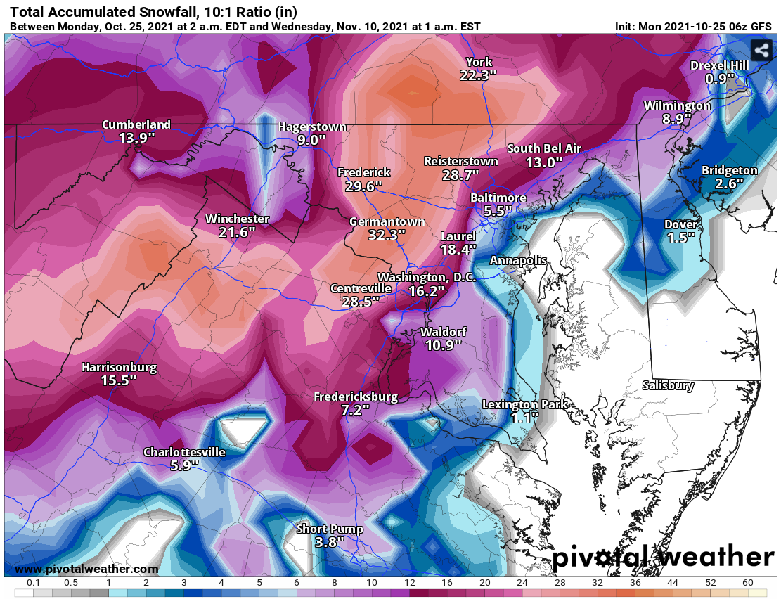
See Digital Snow Thread for the ridiculous Snow Output in GFS Long Range! Maybe getting chilly, at least, in the long-range models!
-
Winter 2021-2022 Digital Snow Thread
midatlanticweather replied to NorthArlington101's topic in Mid Atlantic

-
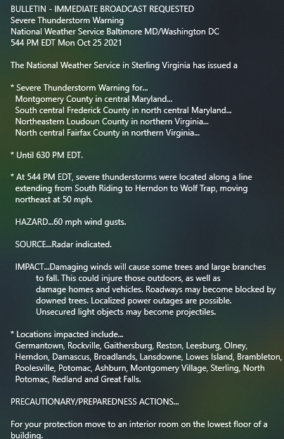
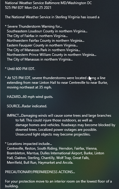
2021 Mid-Atlantic Severe Weather - General Discussion
midatlanticweather replied to Kmlwx's topic in Mid Atlantic
Slight area expanded a bit for tomorrow.thumb.png.ef8267a801ea07717a65e754f7d5a847.png)
-
-
Winter 2021-2022 Digital Snow Thread
midatlanticweather replied to NorthArlington101's topic in Mid Atlantic
-
Very mild morning! Felt nice with a bit of a breeze out there.
-
Absolutely! We know, especially in transition seasons, that the GFS and EURO tend to mild up as we approach the time they think it was going to be very cool! Some cooler temps support is showing up on the Euro.. not close to as cool as the GFS, but at least below normal a bit longer before some warmer temps again. I am thinking the Mountains finally pull off some good frost and maybe a bit of the piedmont if we get lucky! Then we may need to wait again for another shot, but we are way in speculation time period!
-
GFS does a really cool shot next Monday from what I can see! Week out.
-
44 and no heat as well!
-
Saw many Temps down in NC were in the 30s and low 40s!
-
Ended up with 0.24 for rain. Cool water spout shot from the bay https://fb.watch/8G_0B_zAsh/
-
-
IAD: 10/22 BWI: 11/2 DCA: 11/18 RIC: 11/21 1.09
-
2021 Atlantic Hurricane Season Tracking Thread
midatlanticweather replied to WxWatcher007's topic in Mid Atlantic
This is wild! https://fb.watch/8lO69zmMAG/ -
45.9 for the low.
-
Always wonder if this is Banter since it is so early of a forecast: https://www.accuweather.com/en/winter-weather/accuweathers-2021-2022-us-winter-forecast/1022887
-
2021 Mid-Atlantic Severe Weather - General Discussion
midatlanticweather replied to Kmlwx's topic in Mid Atlantic
-
Painful - but true!
-
LOL! GFS is getting funky too! Just so strange looking! Loop this! https://www.pivotalweather.com/model.php?p=500wh&rh=2021092418&fh=loop&dpdt=&mc=&pwplus=1 This is stranger than it looks!

.png.b495231bda5e12940e81a14dc5f442df.png)


