

StantonParkHoya
-
Posts
2,159 -
Joined
-
Last visited
Content Type
Profiles
Blogs
Forums
American Weather
Media Demo
Store
Gallery
Everything posted by StantonParkHoya
-

Mid to Long Range Discussion ~ 2023
StantonParkHoya replied to buckeyefan1's topic in Southeastern States
Having an active STJ means we can accident ourselves into something -
Mid to Long Range Discussion ~ 2023
StantonParkHoya replied to buckeyefan1's topic in Southeastern States
Latest run now keeps the low off the coast completely -
Mid to Long Range Discussion ~ 2023
StantonParkHoya replied to buckeyefan1's topic in Southeastern States
March 19 is technically “astro winter”. Do you think that is good snow climo for us? Met winter exists for a reason. -
Mid to Long Range Discussion ~ 2023
StantonParkHoya replied to buckeyefan1's topic in Southeastern States
We had ice age Christmases last two years and the rest of the seasons sucked, so maybe this does the opposite -
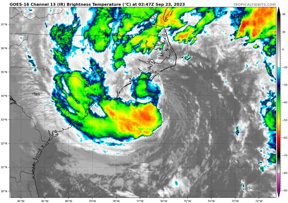
It does that with every system coming from the SE. Same with Union point in new bern that everyone keeps posting. The sensationalism promulgated by social media is out of hand.
-
Was brisk this morning, but now just rain with a little breeze. Time to put this one to bed.
-
what a beaut
-
NWS says we’ve had a gust to 31 but I have yet to see a limb move
-
She’s going to make landfall before 8am per NAM
-
78. This isn’t Florida. Lose the attitude.
-
Water temp at HAT is 77 and 79 at CF, not exactly bath water
-
You realize over-water winds do not translate 1:1 on-land?
- 31 replies
-
- 2
-

-

-
- tropical storm
- nc
- (and 5 more)
-
Nor’easter comma head
-
Haven’t seen a land reporting station gusting over 30 yet
-
Dewpoints in the 50s across central NC
-
If you’ve lived in coastal NC very long, this doesn’t reach excitement level. Kind of like Minneapolis residents and a 4 inch snow.
- 31 replies
-
- 5
-
-

-

-
-
- tropical storm
- nc
- (and 5 more)
-
It’s literally right over where it was before.
-
It’s not tropical
-
Kind of just pinpointing the heavy rain situation at this point. Looks like a STS from Wilmington to offshore NC on the table with 1-5 inches of rain from NC to CT.
-
Euro never brings the STS onshore
-
6z GFS just keeps it offshore and away from CONUS. Have seen a few models want to do this.
-
20-40 mph winds?
-
Euro is…different. Low just meanders and weakens off GA coast.
-
GFS kind of trending this way run-over-run. Could see an OBX skirting situation. Seems like every system this year has had a late eastern shift. Nigel was originally showing a track west of Bermuda to only end up hundreds of miles east.

