StantonParkHoya
-
Posts
2,159 -
Joined
-
Last visited
Content Type
Profiles
Blogs
Forums
American Weather
Media Demo
Store
Gallery
Everything posted by StantonParkHoya
-

2023 Atlantic Hurricane season
StantonParkHoya replied to Stormchaserchuck1's topic in Tropical Headquarters
Little low, maybe a TD? on the euro for GA/SC -
2023 Atlantic Hurricane season
StantonParkHoya replied to Stormchaserchuck1's topic in Tropical Headquarters
I’m not sure El Niño has matured to have an impact on this season, but could see some impacts on next. -
Category Five Hurricane Lee
StantonParkHoya replied to WxWatcher007's topic in Tropical Headquarters
550 miles away. Pretty wild -
2023 Atlantic Hurricane season
StantonParkHoya replied to Stormchaserchuck1's topic in Tropical Headquarters
Looks like GFS goes east of Bermuda and euro goes right over it -
Category Five Hurricane Lee
StantonParkHoya replied to WxWatcher007's topic in Tropical Headquarters
In 48 she begins entering Franklins wake, so SSTs drop off. Don’t think it ever recovers. -
Category Five Hurricane Lee
StantonParkHoya replied to WxWatcher007's topic in Tropical Headquarters
Lee looks like garbage -
Category Five Hurricane Lee
StantonParkHoya replied to WxWatcher007's topic in Tropical Headquarters
She passed north of 20N at about 57.7W. I know we were using 60 as a marker for potential landfalls. -
Category Five Hurricane Lee
StantonParkHoya replied to WxWatcher007's topic in Tropical Headquarters
Everyone needs to chill. This feels like pre-KU snowstorm when people start questioning things. -
Category Five Hurricane Lee
StantonParkHoya replied to WxWatcher007's topic in Tropical Headquarters
Both the Euro and GFS showing a mighty close call on Bermuda. They need to be prepared. -
Category Five Hurricane Lee
StantonParkHoya replied to WxWatcher007's topic in Tropical Headquarters
Those late September MDRs face so much pressure to recurve though -
Category Five Hurricane Lee
StantonParkHoya replied to WxWatcher007's topic in Tropical Headquarters
Euro almost hits Bermuda on the way NE -
Category Five Hurricane Lee
StantonParkHoya replied to WxWatcher007's topic in Tropical Headquarters
I’m confused as to what people are still looking for here? Whether it scrapes MA or ME? I think that’s going to be a gametime decision. -
Category Five Hurricane Lee
StantonParkHoya replied to WxWatcher007's topic in Tropical Headquarters
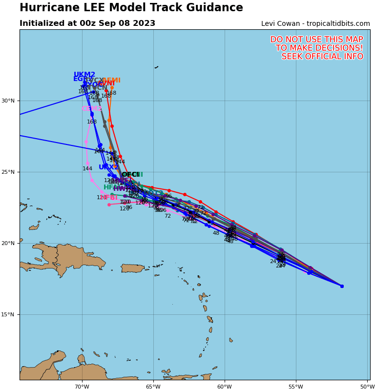
They all bend before 70W when you go out in time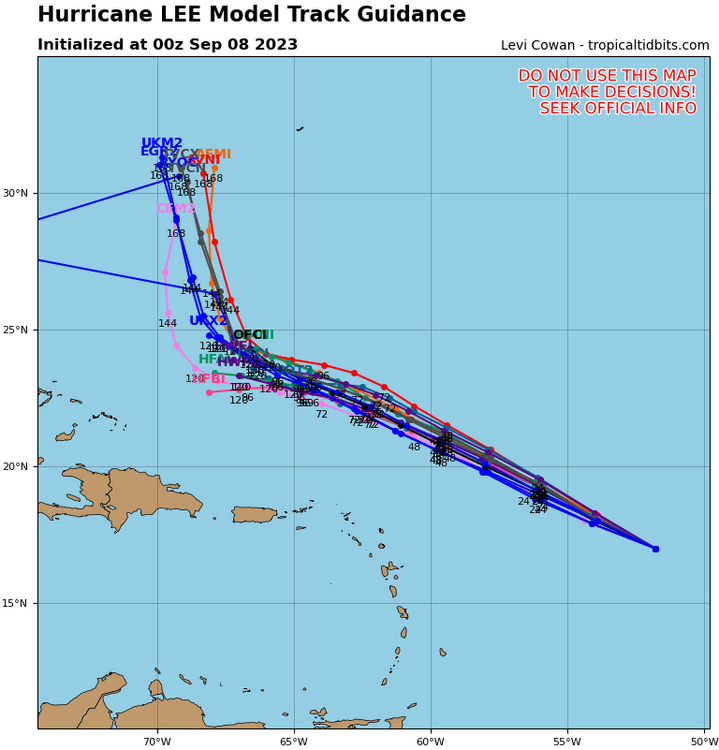
-
Category Five Hurricane Lee
StantonParkHoya replied to WxWatcher007's topic in Tropical Headquarters
0 US hits among GEFS members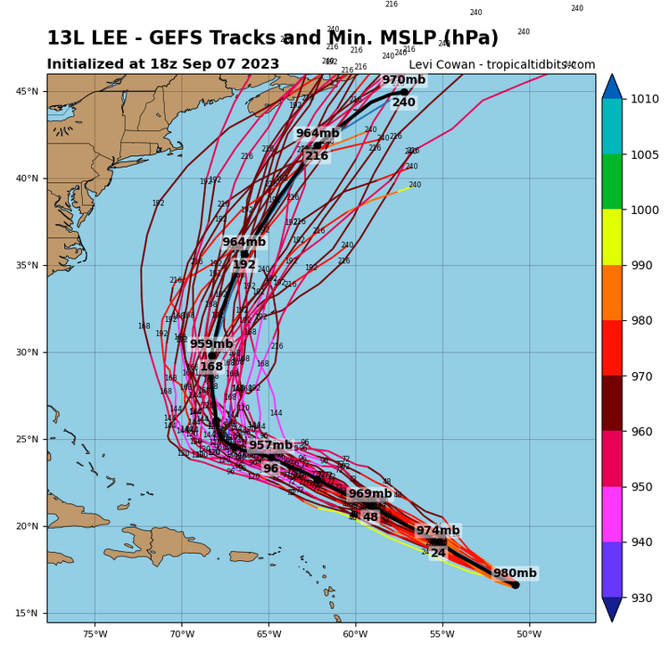
-
Category Five Hurricane Lee
StantonParkHoya replied to WxWatcher007's topic in Tropical Headquarters
GFS hits maritime Canada -
Category Five Hurricane Lee
StantonParkHoya replied to WxWatcher007's topic in Tropical Headquarters
It's not going to be a Cat 4 going through 68-73 degree waters -
Category Five Hurricane Lee
StantonParkHoya replied to WxWatcher007's topic in Tropical Headquarters
It passes through Franklin's upwelling as well -
Which means there’s no chance
-
Category Five Hurricane Lee
StantonParkHoya replied to WxWatcher007's topic in Tropical Headquarters
Godspeed on your endeavors -
Category Five Hurricane Lee
StantonParkHoya replied to WxWatcher007's topic in Tropical Headquarters
One is slower… -
Category Five Hurricane Lee
StantonParkHoya replied to WxWatcher007's topic in Tropical Headquarters
They’re virtually identical. Wishcasting for hits is just as bad or worse as wishcasting for a recurve. -
Category Five Hurricane Lee
StantonParkHoya replied to WxWatcher007's topic in Tropical Headquarters
It's not further west -
Category Five Hurricane Lee
StantonParkHoya replied to WxWatcher007's topic in Tropical Headquarters
12z GFS about 100 miles NE of 6z position through 96 -
Category Five Hurricane Lee
StantonParkHoya replied to WxWatcher007's topic in Tropical Headquarters
6z Euro is actually NE of yesterdays 6z run -
Category Five Hurricane Lee
StantonParkHoya replied to WxWatcher007's topic in Tropical Headquarters
When is recon scheduled to begin?