

StantonParkHoya
-
Posts
1,183 -
Joined
-
Last visited
Content Type
Profiles
Blogs
Forums
American Weather
Media Demo
Store
Gallery
Posts posted by StantonParkHoya
-
-
Any way to bifurcate post-FL Ian landfall analysis and updates and real-time obs/model discussion?
-
 1
1
-
-
2 minutes ago, Bubbler86 said:
How many of NHC's maps had Ian coming off Florida and hitting SC/NC as a Hurricane? I doubt any because no model suggested that until some unnamed models started showing it 2-3 days ago. NHC is as good as the tech.
Well, it hasn't hit SC as a Cat 1 yet. Never underestimate dry air and sheer once north of FL.
-
 1
1
-
-
1 minute ago, Drummer said:
at what point does the banter thread come into play around here?
Yeah, where are the admins?
-
5
-
-
1 minute ago, hawkeye_wx said:
It turned out that some of those early worst-case Euro runs from days ago, which showed Ian turning up into sw Florida, exiting into the Atlantic, then phasing with the tail end of the eastern US trough and moving into the Carolinas as a strong system, were totally correct.
I'm sorry, are you from the future?
-
1
-
 3
3
-
 2
2
-
2
-
-
3 minutes ago, HKY_WX said:
NC piedmont will definitely have some good gusts tomorrow afternoon/evenining. The trends continued to push it further east up the coastline. Combining this with the HP will make for a tight pressure gradient up here. Should be an interesting day tomorrow.
Looks like most models have consolidated around a Charleston hit.
-
3 minutes ago, kvegas-wx said:
Flying into CLT in an hour. Should be fun confirming your observation in real time. Lol.
Happy to see the rainfall forecast continues to decline this weekend across the piedmont and foothills of NC. Need rain, not floods.
That is a bright spot, we've been in a borderline drought this fall, so we can handle a good amount of rain.
-
Here in north-central NC, the wind is already whipping from the pressure gradient w/ the high to our north and Ian to the south. Akin to a nor'easter approaching. Can't recall a tropical storm with temps in the 50s before, but here we are.
-
4
-
-
2 minutes ago, NJwx85 said:
Center is moving offshore now near Port Canaveral. Will be interesting to see how quickly Ian reorganizes over still very warm SST for next 24 hours.
DP of 46 here this morning. Be interesting to see when it goes post tropical
-
1
-
-
Siesta Key, 125mph
-
2 minutes ago, LongBeachSurfFreak said:
Water temps in the high 80s will do that. It’s a new era.
Allot of the it’s Florida we know hurricanes crowd is in for a big surprise
.The temps are 85. The same they were in 1985. Please stay on topic.
-
1
-
3
-
-
Won’t be long before this takes on the ol’ Fibonacci spiral look. Sheer is apparent on northwest side.
-
1 minute ago, MattPetrulli said:
With continued NNE motion, it may come in AT Cape Coral instead of a little north. Hard to tell though.
Good heavens. Current heading is 10 degrees. That is NOT Cape Coral.
-
1
-
2
-
-
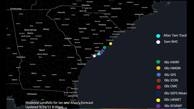
2 minutes ago, WxWatcher007 said:
Here are the 00z spaghetti models. I do wonder how far out over the Atlantic this one will trend. Probably won't make much of a difference as we're currently talking about a minimal category one versus a strong TS, but it is one of those areas where there is still a fair amount of uncertainty and the trend doesn't seem to have stopped yet.
A more progressive track over Florida probably means a greater (to a limit) shift over the Atlantic.

No model to-date has gone north of Charleston that I’m aware
-
2
-
-
1 minute ago, WxSynopsisDavid said:
True but we are now inside the short range and those models are extremely efficient with picking up mesoscale features. I would be concerned with the environment they are depicting later tonight and why they are rapidly intensifying Ian. I haven’t looked at the runs yet so idk what they are picking up but I’ll give them a look and see
HWRF just took the storm from Columbus Ga to Columbia SC in one run… it’s… something
-
2
-
-
1 minute ago, Hotair said:
Already 16,000 customers in Florida without power and storm is still well offshore.
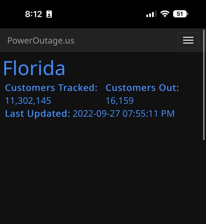
I would bet that’s a normalish number on a regular day out of a 13M home pop
-
Just now, Wannabehippie said:
Isn't wobbling normal in a storm this powerful? Like a top spinning?
It’s been forecast to go NNE. Some posters think they’re Sherlock Holmes discovering a clue.
-
5
-
11
-
1
-
-
Not an active season. Period. Stop it.
-
2
-
-
I thought environment was supposed to degrade precipitously north of Tampa latitude, inland or over water?
What’s the environment look like once this is over Orlando?
-
1 hour ago, Wmsptwx said:
Charley hit Port Charlotte
Can we ban mentions of Charley?
-
6 minutes ago, kvegas-wx said:
I'll go out on a limb here and toss out the idea that Ian's legacy (other than the area of landfall in FL and the track immediately thereafter) will be the inland flooding across GA, SC and NC. We already know what happens in the sandhills of eastern NC when you dump a foot of rain in a day. Been there, done that. A second landfall and potential re-intensification will just add to the misery. I expect evacuations of the Outer Banks to be announced by Thursday. Highway 12 already had sand all over it from Fiona last weekend. They wont take chances.
OBX would be 200+ miles away from 2nd landfall. Seems like a stretch.
-
1
-
-
3 minutes ago, Eskimo Joe said:
Looking like the 2nd landfall is becoming a real possibility.
If it were to, NHC says they do not anticipate any strengthening. Between dry air, sheer, land interaction, etc. seems plausible it would be high end TS.
-
2
-
-
Anyone have the 18z hurricane model tracks? Not fully loading on TT. Thanks.
-
Just now, LeesburgWx said:
The current heading on Visible really looks more ENE than NE.
On its current heading, it landfalls at Port Charlotte
-
3
-
-
HWRF still going directly into Tampa Bay
EDIT: Take that back, actually goes in north of Tampa
-
1
-
 1
1
-

Hurricane Ian
in Tropical Headquarters
Posted
Looks like Euro brings it in directly into Charleston harbor