

StantonParkHoya
-
Posts
1,965 -
Joined
-
Last visited
Content Type
Profiles
Blogs
Forums
American Weather
Media Demo
Store
Gallery
Posts posted by StantonParkHoya
-
-
8 minutes ago, GaWx said:
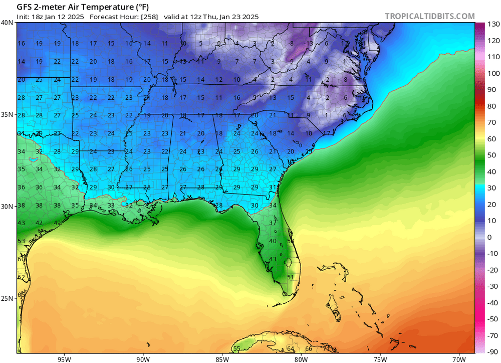
Brick, there hasn’t been a SE storm of this magnitude AND breadth on record going back 150 years! This is like 2/1973 on steroids and 2/1973 without steroids was incredible. So, odds of this combined with the massive N FL Pan/deep SE/coast icestorm verifying closely are infinitesimally tiny. There’s a better chance for me to decide to run for Pres of the US and that’s something I have less than zero interest in ever doing.
We all should keep in mind that a NW trend though not a lock is always likely if there is a storm around then due to cold model biases. It isn’t really a NW trend but rather the models typically being too far SE in the first place because the atmosphere is modeled colder than reality.
This is 1973 meets 2000 meets 1993 Frankenstein
-
 2
2
-
-
 My favorite frame
-
 2
2
-
-
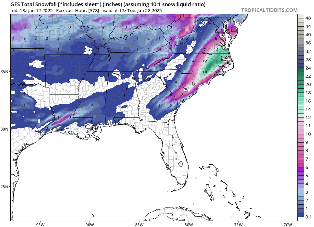
bookmark as one of the weeniest runs of all time for coastal plain NC-
 1
1
-
-
I like that it’s not dependent on a huge bomb for dynamics. This is temp / baroclinic gradient driven.
-
3
-
-
After this last disaster, I want it showing snow in Bermuda until 48 hours out
-
 2
2
-
 1
1
-
-
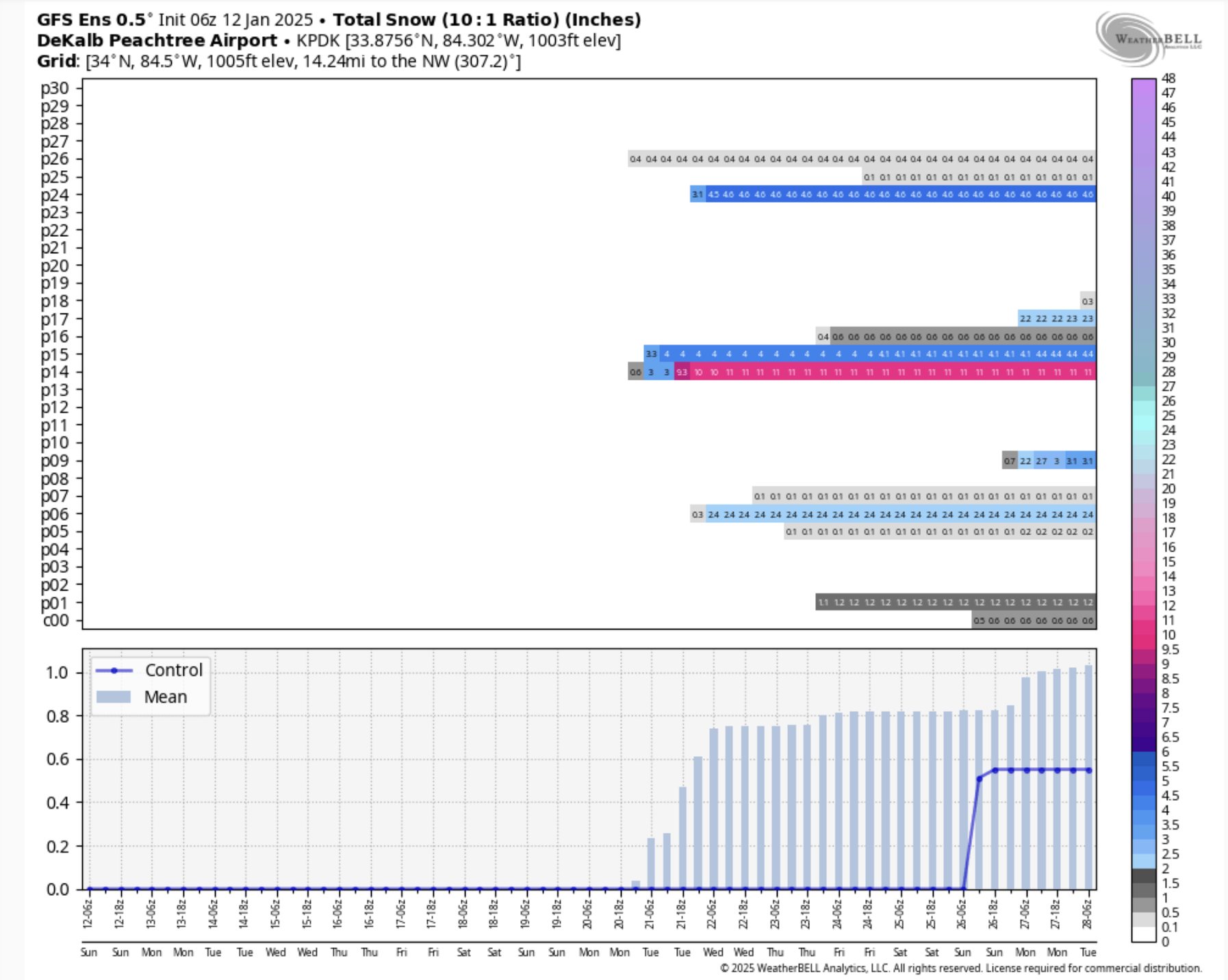
10 minutes ago, Cheeznado said:
Well, there is one GEFS member that has a foot...I agree that the overall pattern might favor some sort of snow event, just do not want to get too excited just yet.

Do you have RDU
-
1 minute ago, WinstonSalemArlington said:
That is really good for 252
-
2
-
-
End of days for Raleigh. We’d never recover.
-
 3
3
-
-
Love it. I will say — when we’re done with this arctic situation through January — I’m ready for spring. Bring on the February bloom.
-
2
-
-
Those 0 degree temps are for the birds unless we can marry up some moisture
-
 1
1
-
1
-
-
19 minutes ago, WinstonSalemArlington said:
2009 was Arctic with temps in the teens during the inauguration. I was there and nearly suffered frostbite. At that time, a raging snowstorm was underway in North Carolina.
Yes there was. Eastern NC got pounded.
-
1
-
-
10 minutes ago, jburns said:
Let’s keep politics out of the weather side.

Would be quite historic for the inauguration to be in a snowstorm
-
2
-
 1
1
-
-
Reminds me very much of 2013-14 with the -EPO and overrunning events one after another
-
2
-
-
It’s going to take a cutter, then an inland runner, and finally ours. Gonna have to step down the zone. Patience.
-
1
-
 1
1
-
-
Because it’s fun, LR GFS has a bomb

-
4
-
 1
1
-
-
Just now, Brick Tamland said:
Climate change. And being close enough to the ocean seems to always put the Triangle on the edge.
For RDU, this track was never hallmark and was always going to present problems. We need a low 50 miles off the coast, not on it. Sure, climate change alters the background state and makes a pure snow outcome less likely on the aggregate, but this was a flawed set up — even in 1960.
-
3
-
1
-
-
6 minutes ago, KrummWx said:
I have friends outside of LR, Arkansas and am pissed bc they got a solid couple inches over ther course of a few hours
 gawd i need to get a wfh job and move north lmao. it's no precip falling at all rn
Weren’t they supposed to get like a foot though? Been there, would rather bust not expecting much to begin with.
-
An aside, and not to be sentimental, but it’s so cool when you pass down this weird hobby to your kids. I have a 6 year old daughter who now wants to watch the model runs with me and put out snow boards to measure what has fallen.
-
12
-
-
1 minute ago, Snowacane said:
Heavy rain now
It is literally frozen rain. It’s 28 degrees. It’s not just raining like we’re in the Amazon.
-
3
-
2
-
-
Will say it feels like a poor return on investment to spend 10+ days tracking a storm for 1.5 inches of snow. But the 2 hours it dumped were a ton of fun.
-
3
-
1
-
-
4 minutes ago, Snowacane said:
Damn, NAM got it again
Not really. I have over an inch of snow already and NAM had me at 0.6
-
2
-
-
2 minutes ago, sarcean said:
Raining in Charlotte area now yet it's 29 out. I can't imagine the ice mess this will cause once it all freezes. It might be freezing rain already but its coming down as mainly rain.
That’s what freezing rain looks like
-
3
-
5
-
-
Any posters in the Roxboro, Oxford, Henderson quadrant?
-
Back to fatties


Mid to long range discussion- 2025
in Southeastern States
Posted
Let’s party like it’s 2009 again