OrdIowPitMsp
-
Posts
2,565 -
Joined
-
Last visited
Content Type
Profiles
Blogs
Forums
American Weather
Media Demo
Store
Gallery
Everything posted by OrdIowPitMsp
-
Frost Advisory tonight. Freeze warnings just north. First winterish headline of the season here.
-
First sub-60 high at MSP since June 13th. Frost advisories just north of the metro.
-

-
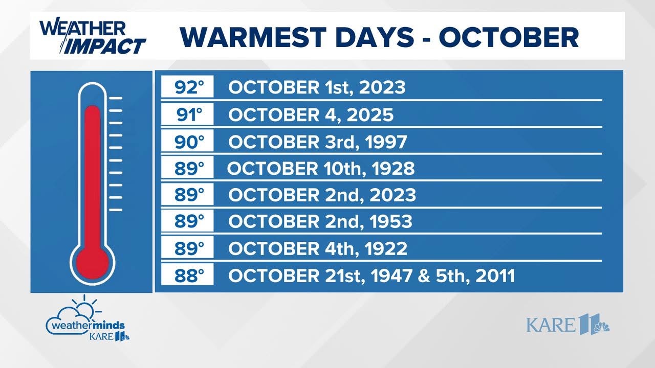
Record high of 91 at MSP. This is the latest occurrence in the year of a 90+ temperature on record for Minneapolis. Presumably we will also set a record high min of 72 today as well.
-
87 both yesterday and today at MSP. Temps actually underperformed a bit today versus guidance. Tomorrow is our best shot at an October 90 with blast furnace winds from the south.
-
Extension of summer here for sure. It has been 90 or warmer a grand total of 3 times in October in Minneapolis. We could add 2 this year. The all time warmest overnight low for the month could be in jeopardy too. I still think we see a dusting of snow by Halloween.
-

Fall 2025 Medium/Long Range Discussion
OrdIowPitMsp replied to Chicago Storm's topic in Lakes/Ohio Valley
Extended looks warm and dry. We’ll probably continue with highs in the 70s until the inevitable sharp cold front and first flakes around October 18-20th. Seems to happen like that almost every year around here. -
Wet day in the Twin Cities. After a dry stretch this is welcome moisture as the Butternut Squash in my garden gets ready to be harvested.
-
Late season 90 achieved at MSP. The record of 94 appears to be safe but still a couple hours of warming to go.
-
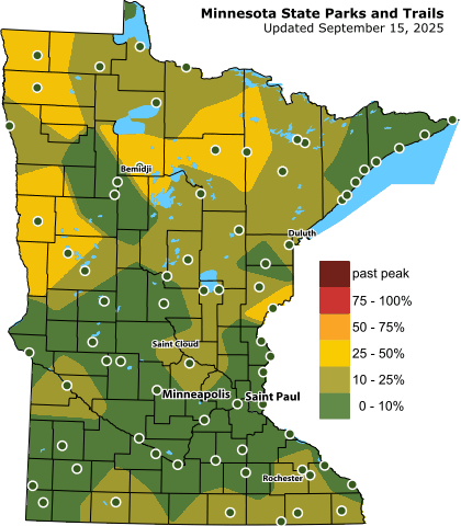
Saw some pockets of decent color on my drive to Willmar MN today.
-
Thanks, I love my South Minneapolis neighborhood. The home with the wreath on the front door is an Airbnb, directly across the street from us.
-
St. Helena’s Church puts on an Autumn Daze festival every year with a parade that goes down our street. Our block makes a big party out of it. Kids and adults love a good parade.

-
Looks likely we bag a late season 90 at MSP this weekend.
-
Very dense fog this AM. Airport has had visibility around a quarter mile.
-
International Falls got down to 29 this morning. Bemidji was 32.
-
We haven’t turned ours on yet, the house has been staying around 65-67 with the windows closed and lows in the mid 40s down here. Natural gas fireplace has been flipped on though.
-
Heat Island kept MSP at a relatively mild 46 overnight.
-
There’s an outside chance Minnesota sees it’s earliest accumulating snow on record. September 14th 1964 0.3” fell at International Falls, so if anything accumulates the record will be shattered.
-
Solid garden variety storms rolling through the metro this morning. Needed the moisture after a couple dry weeks.
-
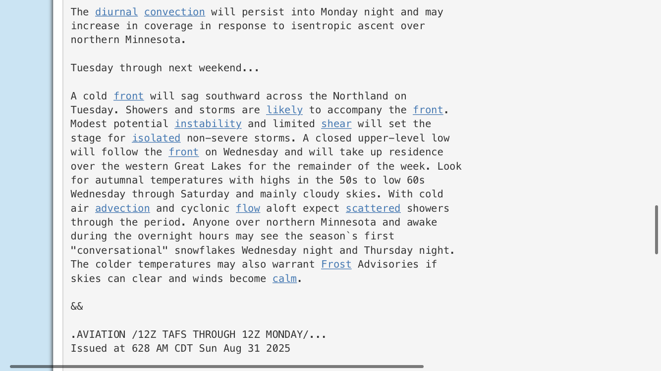
NWS Duluth seems to have latched onto the idea of first flakes.
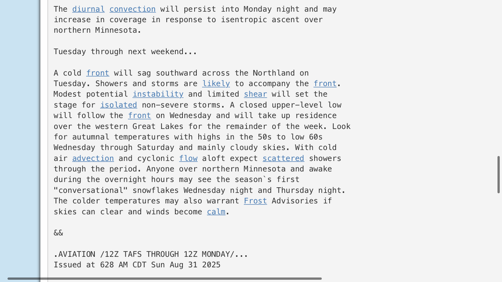
-
NWS talking 850mb temps below freezing here next week.
-
44.53+ N checking in. Some color on random maples and cottonwoods, but that happens every year.
-
Crisp fall days are here. Dewpoint down to 41 at msp.
-
89’d today, maybe the last wave of 70 dews for the year.
-
1” of rain Saturday 1” of rain last evening.