CheeselandSkies
-
Posts
3,390 -
Joined
-
Last visited
Content Type
Profiles
Blogs
Forums
American Weather
Media Demo
Store
Gallery
Everything posted by CheeselandSkies
-
HRRR has a pretty good soaker for IA and most of northern IL through tomorrow morning.
-
Summer 2026 Med/Long Range Discussion
CheeselandSkies replied to Brian D's topic in Lakes/Ohio Valley
If anything from the ATL side can survive the Godzilla Nino... -
2026 Severe Wx - General Thread
CheeselandSkies replied to largetornado's topic in Lakes/Ohio Valley
Yeah, earlier model runs showing a good MCV threat somewhere from N IL to OH for today were a big tease. -
2026 Severe Wx - General Thread
CheeselandSkies replied to largetornado's topic in Lakes/Ohio Valley
That's actually most of an average yearly count for the state (50-54 depending on the source). Could get a few more Saturday per NAM; although bulk shear will be weak there is a 700mb shortwave trough with ample low-level turning and 0-3KM CAPE. -
Consistent miss south for Madison and points north in southern Wisconsin, as well. Naturally Wausau area managed a few severe storms late last night despite being well north of even the marginal risk contour.
-
2026 Severe Wx - General Thread
CheeselandSkies replied to largetornado's topic in Lakes/Ohio Valley
Unfortunately more recent HRRR runs pointing toward more of an after dark event again. -
2026 Severe Wx - General Thread
CheeselandSkies replied to largetornado's topic in Lakes/Ohio Valley
12Z HRRR and nest both became rather interesting for this evening from the state line into Chicagoland. Maybe what I thought might happen (in daylight) yesterday, will happen today. -
2026 Severe Wx - General Thread
CheeselandSkies replied to largetornado's topic in Lakes/Ohio Valley
6th anniversary of the Big Wind Bag of 2020: -
2026 Severe Wx - General Thread
CheeselandSkies replied to largetornado's topic in Lakes/Ohio Valley
If only it was all 4 hours earlier. -
2026 Severe Wx - General Thread
CheeselandSkies replied to largetornado's topic in Lakes/Ohio Valley
Looks like a swing and a miss for a peak heating supercell threat today. However 5 years ago OTD was a different story. I remember @Chicago Storm being super gung ho about this setup on here which was one of the reasons I went for it despite SPC only having a 2% (later upgrade to 5%). He nailed the longer-lived/more photogenic Sycamore-Virgil tornadoes. I saw the storm I was on go HP on the next cycle and started for home, thinking it would have worked over the atmosphere. However I still consider the Kirkland EF1 my first "official" tornado since it's the first one I was actually able to stop, tripod and watch for a few minutes instead of frantically driving to get either closer to (such as the Esmond EF0 at the beginning of the video) or out of the way of it. -
Congrats, will miss having another Madisonian on the board, though.
-
In The Eye of the Storm: Chasers
CheeselandSkies replied to Coach McGuirk's topic in Weather Forecasting and Discussion
-
Ready for some winter outbreaks.
-
In The Eye of the Storm: Chasers
CheeselandSkies replied to Coach McGuirk's topic in Weather Forecasting and Discussion
Pipe. Yes, they were probably overexcited, BUT violent tornadoes don't have to be wedges, AND there are numerous non-meteorological reasons the EF5 rating has become very difficult to have applied at an official level. -
2026 Severe Wx - General Thread
CheeselandSkies replied to largetornado's topic in Lakes/Ohio Valley
500mb pattern recognition via GFS/NAM suggests something may happen Wednesday although runs differ where/if significant instability may develop given ample/persistent convection. At least could be another good soak for NW parts of the sub. -
Did not expect something on the magnitude of that Menasha area tornado. Reminds me a bit of a slightly less intense Plainfield. Sneaky high-CAPE HP sigtor in what was expected to be a summer wind bag. Likewise also missed a potentially much more catastrophic impact by a day (EAA had ended the day before, in Plainfield school started the day after).
-
As usual it takes the most annoying possible path. Rides the eastern fringe of the Madison media market. Not a drop here but we still have to be wall-to-wall for the tornado warnings.
-
HRRR now selling a total miss east for WI/IL.
-
2026 Severe Wx - General Thread
CheeselandSkies replied to largetornado's topic in Lakes/Ohio Valley
Actually reminds me a bit of 7/12/23 in NE IL. What look like rain showers on radar spinning up little tornadoes seemingly at will. Salty because I targeted NE IA to SW WI and just drove in a big circle while seeing nothing as the storms moving into northern IA turned into a big blob except for the far west end, and from what I can tell even that wasn't that great. Got home about 2 hours ago. Based on forecast parameter space these things should have been Plains-caliber cyclic tornadic beasts. SPC MD has some good details on why this wasn't the case: https://www.spc.noaa.gov/products/md/md1682.html -
Smoke rain now. Will be interesting to see how my Corolla which is parked outside looks after this.
-
Hell I'll gladly take some footage of a smoke if it forms within view of my porch. Otherwise I'm getting hammered after work and staying tf inside.
-
Tuesday was 5 years since a fairly prolific tornado outbreak in north central-northeast Iowa. I managed to put myself in great position for the Waverly multivortex EF2 and then blow it, only getting 30 seconds or so of footage AFTER it produced its last visibly condensed vortex. Thus I don't count it as my "official" first tornado although I did glimpse an elephant's trunk vortex in my rear view mirror before pulling over, snapping a photo (during which it was still partially condensed) and then rolling video after which it stubbornly refused to condense again and I was apparently more interested in filming the more visually ominous inflow band.
-
2026 Severe Wx - General Thread
CheeselandSkies replied to largetornado's topic in Lakes/Ohio Valley
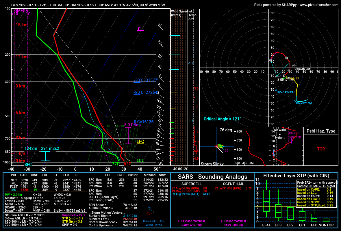
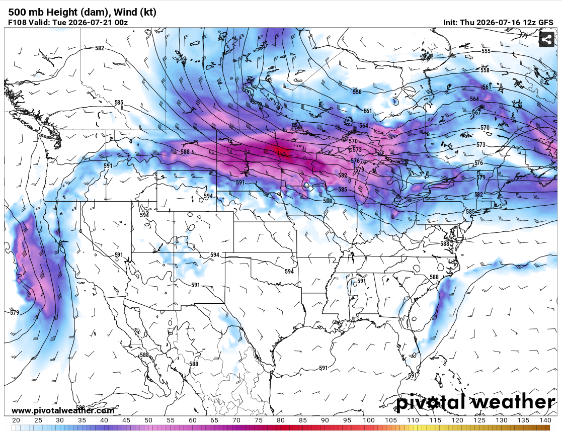
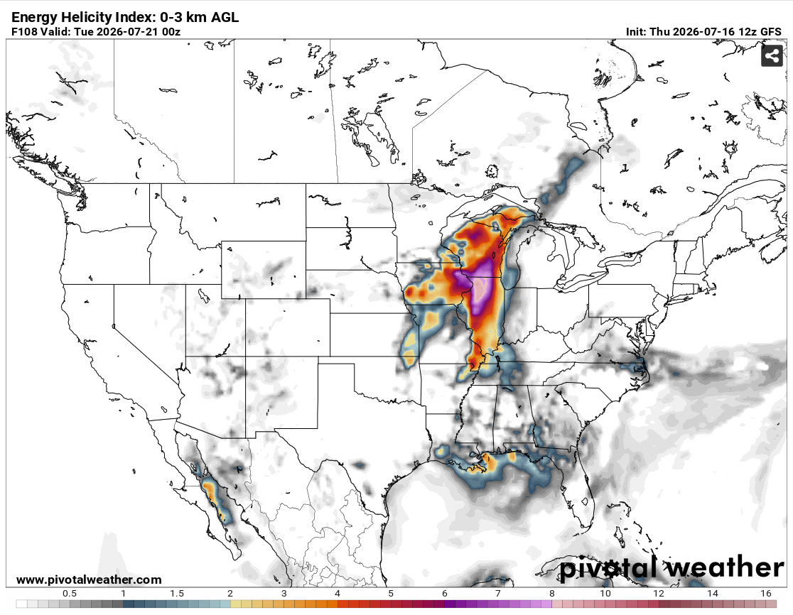
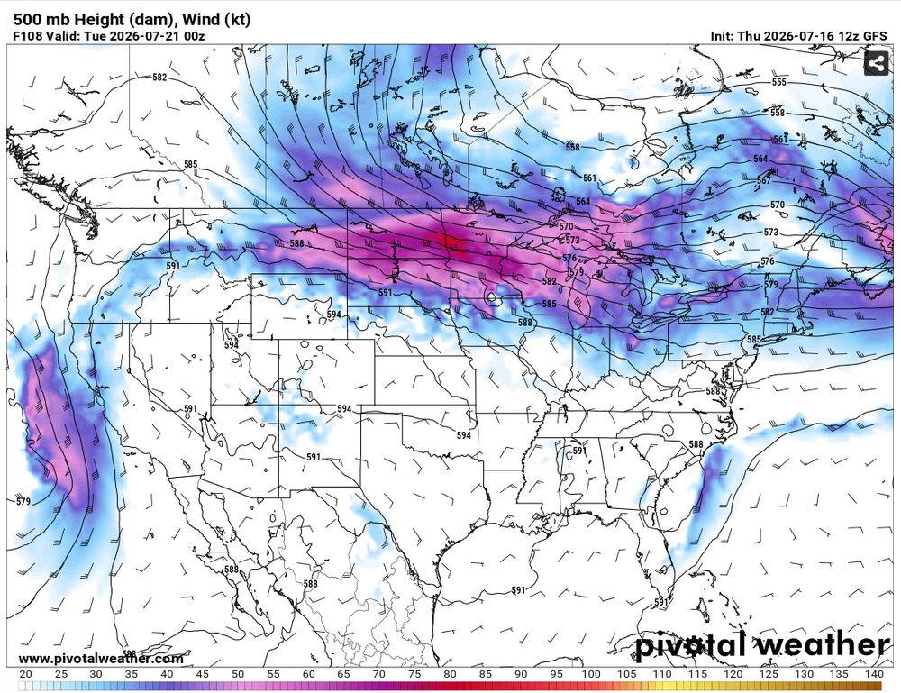
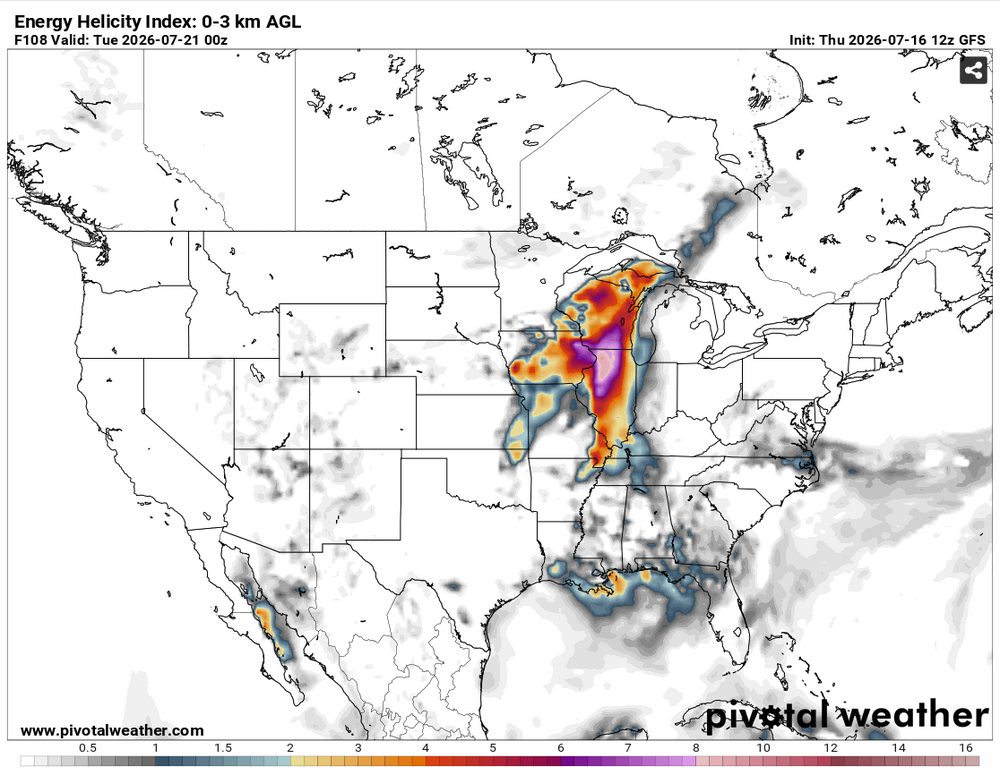
12Z GFS (among other models/ensembles as per SPC's latest 4-8) is spicy for Monday 7/20. However I think a lot is going to depend on if these fires can be tamped down somewhat in the meantime, as this would be another northwest flow setup.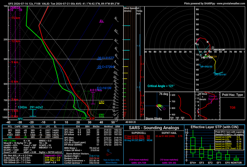
-
Mets at my work said we hit upper 400s for AQI around midday, shattering the old record for Madison (set during Smokeageddon '23). However my phone hasn't budged from the 156 it displayed early this morning, even after I rebooted it.
-
Yuck. I think the highest I saw on my phone during Smokeageddon '23 was in the high 300s. 156 right now. Definitely has that hazy look and campfire smell.