George BM
-
Posts
3,053 -
Joined
-
Last visited
Content Type
Profiles
Blogs
Forums
American Weather
Media Demo
Store
Gallery
Everything posted by George BM
-
Honestly, if there was a MOD+ risk severe day and you didn't make an appearance here I would send out a BOLO for you to every agency around.
- 1,093 replies
-
- 2
-

-

-
- severe
- thunderstorms
- (and 1 more)
-
Well hello there pinned severe thread. First time we've done one since February 25, 2017 IIRC when Ian made one for that event (That event produced an EF-1 in La Plata IIRC).
- 1,093 replies
-
- 1
-

-
- severe
- thunderstorms
- (and 1 more)
-
Sky has a bit of a hazy look with an orange tinge to the sunlight.
-
2026 Mid-Atlantic Severe Storm General Discussion
George BM replied to Kmlwx's topic in Mid Atlantic
IAD has peaked at 86F so far! -
And IAD as well it would seem.
-
IAD has hit 85F so far!
-
Outta gas and Outta Time: Early March Winter Storm finale
George BM replied to Ji's topic in Mid Atlantic
You gotta drive over there. -
11/30/2025: T (A mix of rain/sleet from the 4am hour through about 9am. Intensity got up to light/moderate intensity at times. Temps: low/mid 30s 12/02/2025: T (Probably had a brief period of sleet w/ rain sometime between 4:30am and 5am when precip started before quickly changing to a cold rain that became moderate at times during the morning.) 12/05-06/2025: 1.4" (Flurries/very light snow starting in the 4am hour intensifying to light snow between 6am and 10am (light/moderate at times). Flurries to very light snow showers continuing through the rest of the morning ending during the 12pm hour. ETA: Another few bursts of sometimes moderate snow with big aggregates between 10:30pm and around midnight or so dropping an additional 0.2".) 12/11/2025: T (A few flakes in the air during the morning on a northwesterly surface wind.) 12/14/2025: 0.9" (Mixed rain/snow starting after midnight on the 14th, changing over to snow sometime during the 3am hour and lasting through about 6:30am. Snow was moderate at times between 4am and 5:45am. It was graupelly in consistency.) 12/26/2025: T (A mix of light rain/sleet between 10:30am and 12pm. It was briefly freezing rain/sleet as temps fell to 31F during the precip.) 1/01/2026: 0.1" (A squall of heavy snow blew through between 5:18am and 5:35am with visibilities dropping to <= 1/4 mile briefly between 5:21am and 5:25am. Note: could have been 0.2" but the wind 25-30mph gusts made it difficult to tell.) 1/11/2026: T (A few wet flakes with a dying snow/graupel squall around 1:30-1:45pm.) 1/17/2026: 0.4" (Flakes started falling around 8:45am. At 8:48am intensity rapidly jumped from flurries to moderate+ within 15 seconds. Between 9-9:05am the snow was fairly heavy at times. Snow tapered off to flurries by 9:15am. There was a snow/graupel mix that briefly got up to light/moderate intensity around 10am. Snow/graupel tapered off by 10:30am as the last flakes concluded.) 1/18/2026: T (Off and on light rain, probably mixed in with mangled flakes predawn (1:30am-6:30am). An afternoon round of flurries between 4 and 5pm.) 1/24-25/2026: 8.0" (Flurries starting in the 11pm hour on the 24th intensifying into a light snowfall after midnight. Snow becoming moderate at times through the predawn hours. Some moderate+ rates in the 6am hour, then light/moderate through 7:30am when sleet mixes in. Back and forth between sleet and snow/sleet mix through 8:10am when sleet takes over for good. Sleet was moderate at times with snow grains mixed in throughout the morning. Waves of heavy sleet moved through during the afternoon (mainly between 1:30pm and 4pm). Sleet continued in light/moderate intensity afterwards until 5:30pm when it became light. Light sleet continued until precip wrapped up around 7pm. Snow grains were mixed in w/ the sleet (especially before 3pm.)) 2/06/2026: 0.3" (Flurries starting after midday becoming a period of light snow between 2:30pm and 4:30pm. Snow tapering off to flurries afterwards and ending by 5:20pm.) 2/07/2026: T ( Flurries/light snow showers associated with a strong cold front that moved through from NW to SE in the 2am hour.) 2/22/2026: 2.6" (Snow starts mixing in with rain around 2pm. More mixes in until it’s a moderate wet snow by 4pm. Snow becomes moderately heavy during the 5pm hour. Snow tapered off to light intensity during the 6 and 7pm hours. Became moderate again with the western snow band by 8pm w/ increasingly gusty winds. Snow lightened up during the 9pm hour and stopped with the exception of a few flurries throughout the night by 10pm.) Snow totals as of March 2nd, 2026: 13.7"
-
Forecast Discussion Tuesday, March 17, 2026 1:53PM EDT Severe Thunderstorm Watch in effect until 8PM EDT Tuesday, March 17, 2026 SPC Outlook Tornado: 5%, Wind: 90% CIGI 1, Hail: 5% Unseasonably warm and humid conditions remain in place throughout the region early this afternoon with upper 70s to mid 80s surface temps and low to mid 60s dewpoints. This is allowing for MLCAPE of 500-800+ J/kg. Strong ridge of high pressure remains entrenched over the southeastern US with a stationary front draped just to our north. Between the high to the south and lower heights to the north there is a belt of strong 50-60+ kt deep-layer flow (400-700mb). A well-developed severe MCS/derecho w/ an associated cold pool/ rear-inflow jet is currently located over eastern WV and will move across the entire region over the next several hours. Steepening low-level lapse rates and sufficient CAPE should allow this MCS to survive the trek over the mountains and cruise through the area. Widespread severe winds are, by far, the main threat with these storms, though a few QLCS tornadoes are certainly a threat given some fairly decent low-level shear (effective SRH in excess of 250 m2/s2). The Storm Prediction Center in Norman, OK has placed the entire area under a 90% wind risk w/ a level one CIGI which correlates to a moderate (level 4/5) risk. Moderate risk days from the SPC are rare as we’ve only had two such days previously in the last 13 years. Widespread wind gusts of 60-80 mph w/ a few locally higher gusts are expected as the line moves through at around 55-60kts. Skies will clear through the evening with temps holding in the 60s throughout the night before another round of potential severe storms tomorrow with the cold front pushing through from northwest to southeast as a more potent shortwave moves just to our north. Temps and dewpoints will be similar to today ahead of the front.
-
Warmer weather awaits. Welcome to Meteorological Spring peeps!
-
2026 Mid-Atlantic Severe Storm General Discussion
George BM replied to Kmlwx's topic in Mid Atlantic
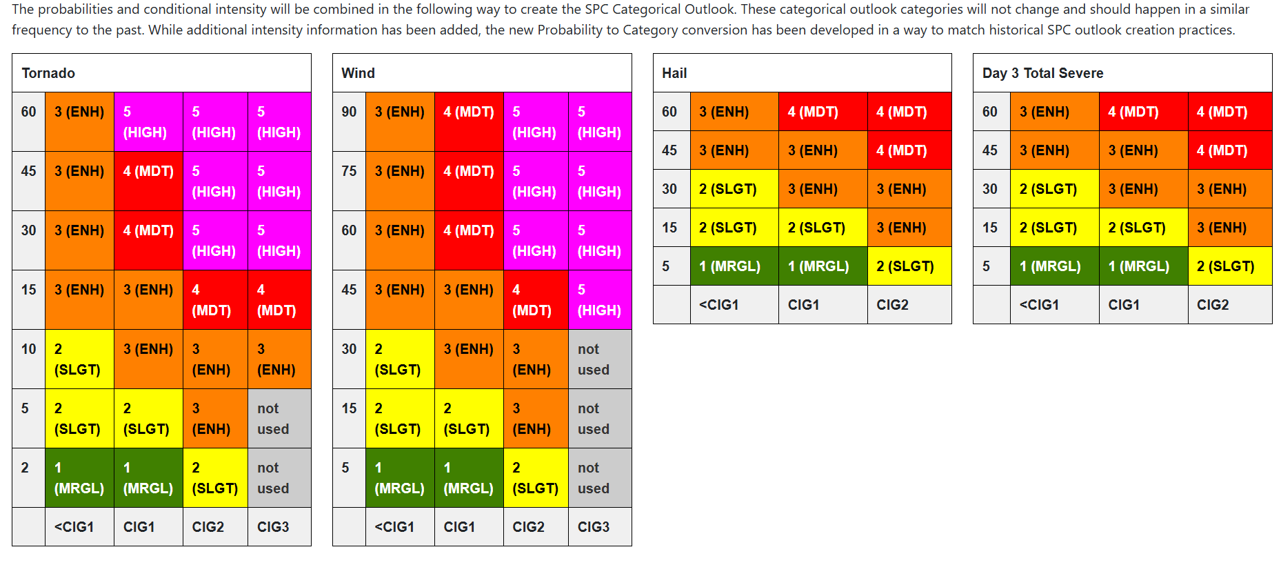
Remember... the new type of convective outlooks come out starting next week with the 1630z Day 1 March 3rd outlook. https://www.spc.noaa.gov/exper/conditional-intensity-information/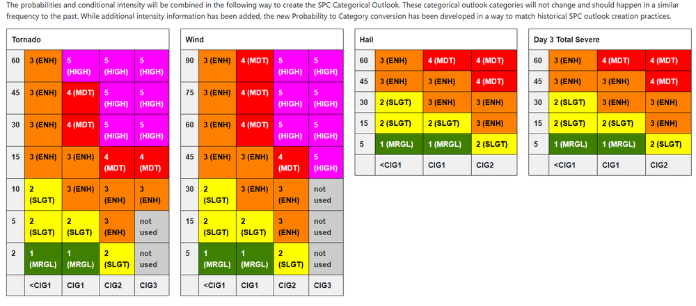
- 1,460 replies
-
- 2
-

-
- severe
- thunderstorms
- (and 7 more)
-
Feb 22nd/23rd "There's no way..." Obs Thread
George BM replied to Maestrobjwa's topic in Mid Atlantic
Into the norlun I go. Herndon, VA. Snowy and kinda windy. -
Feb 22nd/23rd "There's no way..." Obs Thread
George BM replied to Maestrobjwa's topic in Mid Atlantic
1.9" so far in Herndon, VA. -
Feb 22nd/23rd "There's no way..." Obs Thread
George BM replied to Maestrobjwa's topic in Mid Atlantic
Grass whitening under moderate snow. Herndon, VA -
Feb 22nd/23rd "There's no way..." Obs Thread
George BM replied to Maestrobjwa's topic in Mid Atlantic
Hello neighbor! Snow mixing in here nicely in Herndon. -
11/30/2025: T (A mix of rain/sleet from the 4am hour through about 9am. Intensity got up to light/moderate intensity at times. Temps: low/mid 30s 12/02/2025: T (Probably had a brief period of sleet w/ rain sometime between 4:30am and 5am when precip started before quickly changing to a cold rain that became moderate at times during the morning.) 12/05-06/2025: 1.4" (Flurries/very light snow starting in the 4am hour intensifying to light snow between 6am and 10am (light/moderate at times). Flurries to very light snow showers continuing through the rest of the morning ending during the 12pm hour. ETA: Another few bursts of sometimes moderate snow with big aggregates between 10:30pm and around midnight or so dropping an additional 0.2".) 12/11/2025: T (A few flakes in the air during the morning on a northwesterly surface wind.) 12/14/2025: 0.9" (Mixed rain/snow starting after midnight on the 14th, changing over to snow sometime during the 3am hour and lasting through about 6:30am. Snow was moderate at times between 4am and 5:45am. It was graupelly in consistency.) 12/26/2025: T (A mix of light rain/sleet between 10:30am and 12pm. It was briefly freezing rain/sleet as temps fell to 31F during the precip.) 1/01/2026: 0.1" (A squall of heavy snow blew through between 5:18am and 5:35am with visibilities dropping to <= 1/4 mile briefly between 5:21am and 5:25am. Note: could have been 0.2" but the wind 25-30mph gusts made it difficult to tell.) 1/11/2026: T (A few wet flakes with a dying snow/graupel squall around 1:30-1:45pm.) 1/17/2026: 0.4" (Flakes started falling around 8:45am. At 8:48am intensity rapidly jumped from flurries to moderate+ within 15 seconds. Between 9-9:05am the snow was fairly heavy at times. Snow tapered off to flurries by 9:15am. There was a snow/graupel mix that briefly got up to light/moderate intensity around 10am. Snow/graupel tapered off by 10:30am as the last flakes concluded.) 1/18/2026: T (Off and on light rain, probably mixed in with mangled flakes predawn (1:30am-6:30am). An afternoon round of flurries between 4 and 5pm.) 1/24-25/2026: 8.0" (Flurries starting in the 11pm hour on the 24th intensifying into a light snowfall after midnight. Snow becoming moderate at times through the predawn hours. Some moderate+ rates in the 6am hour, then light/moderate through 7:30am when sleet mixes in. Back and forth between sleet and snow/sleet mix through 8:10am when sleet takes over for good. Sleet was moderate at times with snow grains mixed in throughout the morning. Waves of heavy sleet moved through during the afternoon (mainly between 1:30pm and 4pm). Sleet continued in light/moderate intensity afterwards until 5:30pm when it became light. Light sleet continued until precip wrapped up around 7pm. Snow grains were mixed in w/ the sleet (especially before 3pm.)) 2/06/2026: 0.3" (Flurries starting after midday becoming a period of light snow between 2:30pm and 4:30pm. Snow tapering off to flurries afterwards and ending by 5:20pm.) 2/07/2026: T ( Flurries/light snow showers associated with a strong cold front that moved through from NW to SE in the 2am hour.) Snow totals as of February 22nd, 2026: 11.1"
-
URGENT - WEATHER MESSAGE National Weather Service Baltimore MD/Washington DC 219 AM EST Fri Feb 6 2026 DCZ001-MDZ013-014-016>018-504-VAZ053-054-501-505-506-526-527-061530- /O.CON.KLWX.HW.W.0001.260207T0900Z-260208T0000Z/ /O.CON.KLWX.CW.Y.0011.260207T0900Z-260208T1500Z/ District of Columbia-Prince Georges-Anne Arundel-Charles-St. Marys-Calvert-Central and Southeast Montgomery-Fairfax- Arlington/Falls Church/Alexandria-Northern Fauquier-Western Loudoun-Eastern Loudoun-Northwest Prince William-Central and Southeast Prince William/Manassas/Manassas Park- 219 AM EST Fri Feb 6 2026 ...HIGH WIND WARNING REMAINS IN EFFECT FROM 4 AM TO 7 PM EST SATURDAY... ...COLD WEATHER ADVISORY REMAINS IN EFFECT FROM 4 AM SATURDAY TO 10 AM EST SUNDAY... * WHAT...For the High Wind Warning, northwest winds 20 to 30 mph with gusts up to 60 mph expected. For the Cold Weather Advisory, very cold wind chills as low as 13 below expected. * WHERE...Portions of DC, central and southern Maryland, and northern Virginia. * WHEN...For the High Wind Warning, from 4 AM to 7 PM EST Saturday. For the Cold Weather Advisory, from 4 AM Saturday to 10 AM EST Sunday. * IMPACTS...Damaging winds will blow down trees and power lines. Widespread power outages are expected. Travel will be difficult, especially for high profile vehicles. The cold wind chills as low as 15 below zero could result in hypothermia if precautions are not taken. * ADDITIONAL DETAILS...Wind chills will remain at or below zero during the day on Saturday due to windy conditions and cold temperatures. PRECAUTIONARY/PREPAREDNESS ACTIONS... Remain in the lower levels of your home during the windstorm, and avoid windows. Watch for falling debris and tree limbs. Use caution if you must drive. Use caution while traveling outside. Wear appropriate clothing, a hat, and gloves. Keep pets indoors as much as possible. Make sure outdoor animals have a warm, dry shelter, food, and unfrozen water. && $$
-
Same experience here in Herndon, VA yesterday afternoon in the sun with a moment of no wind. "Kinda nice actually..." It was 19F.
-
Saturday, February 14, 2026 1:28PM EST Blizzard Warning in effect from 5PM EST Saturday, February 14, 2026 until 4AM EST Sunday, February 15, 2026. Cold Weather Advisory in effect from 9PM EST Saturday, February 14, 2026 until 9AM EST Sunday, February 15, 2026. Showers and thunderstorms have started popping up along the cold front along I-81 in Maryland and extending down into northwestern VA. These will get more organized and quickly move east across the region with the front cruising through. With MLCAPE approaching 500 J/kg owing to the cooling mid-levels above surface temperatures and dewpoints into the low/mid 60s and upper 40s/low 50s respectively, some hail, perhaps marginally severe, as well as strong/damaging wind gusts will accompany these storms. This is in response to a very strong and compact, cold shortwave diving out of the northwest. As we get into the late afternoon and evening hours this shortwave will be strongly interacting with the frontal boundary that will be over our eastern areas during this time. As a result, a surface low will explosively deepen over southern MD as increasingly heavy anafrontal precip blossoms over the entire region as very strong lift underneath impressive upper-level divergence overspreads the region. Rain will quickly change over to snow as precip becomes heavy and as much colder air behind the front surges in. The deepening low will not be moving much as it phases in with the shortwave allowing bands of very to extremely heavy snow to organize over the region west of the Chesapeake Bay. This will also increase the surface pressure gradient leading to strong/damaging NW winds gusting up to the 55 to 65mph range. Continued strong CAA through the evening will allow temps to drop into the upper teens in most areas, especially as the storm starts pull east later tonight, dropping windchills to near 5F below zero. All in all, with 3 to 5+ inch/hr snowfall rates and sustained winds over 40mph w/ up to 65mph wind gusts reducing visibilities to 200 feet or less at times over the course of roughly 5 to 7 hours, this will far exceed the threshold for blizzard conditions. Sensible weather-wise this will be similar in magnitude to the Presidents Day Storm of 1979 with the two noticeable differences being the most intense blizzard conditions occurring over the immediate DC metro area and the fact that it is very warm leading up to this storm. The pre-storm warmth will mean that there is the added danger of initially wet pavement and roads freezing over once temperatures drop below freezing making for dangerous travel conditions. After midnight the compact storm will pull east-southeastwards allowing snow to end from west to east. Snowfall totals will range from 18-24 inches across most of the region with localized spots getting up to 30 inches, particularly higher windward elevations north and west as well as any areas that get stuck under a heavy snow band. With the high winds associated with the storm, however, snow drifts could be as high as 12 to 15 feet in some spots.
-
11/30/2025: T (A mix of rain/sleet from the 4am hour through about 9am. Intensity got up to light/moderate intensity at times. Temps: low/mid 30s 12/02/2025: T (Probably had a brief period of sleet w/ rain sometime between 4:30am and 5am when precip started before quickly changing to a cold rain that became moderate at times during the morning.) 12/05-06/2025: 1.4" (Flurries/very light snow starting in the 4am hour intensifying to light snow between 6am and 10am (light/moderate at times). Flurries to very light snow showers continuing through the rest of the morning ending during the 12pm hour. ETA: Another few bursts of sometimes moderate snow with big aggregates between 10:30pm and around midnight or so dropping an additional 0.2".) 12/11/2025: T (A few flakes in the air during the morning on a northwesterly surface wind.) 12/14/2025: 0.9" (Mixed rain/snow starting after midnight on the 14th, changing over to snow sometime during the 3am hour and lasting through about 6:30am. Snow was moderate at times between 4am and 5:45am. It was graupelly in consistency.) 12/26/2025: T (A mix of light rain/sleet between 10:30am and 12pm. It was briefly freezing rain/sleet as temps fell to 31F during the precip.) 1/01/2026: 0.1" (A squall of heavy snow blew through between 5:18am and 5:35am with visibilities dropping to <= 1/4 mile briefly between 5:21am and 5:25am. Note: could have been 0.2" but the wind 25-30mph gusts made it difficult to tell.) 1/11/2026: T (A few wet flakes with a dying snow/graupel squall around 1:30-1:45pm.) 1/17/2026: 0.4" (Flakes started falling around 8:45am. At 8:48am intensity rapidly jumped from flurries to moderate+ within 15 seconds. Between 9-9:05am the snow was fairly heavy at times. Snow tapered off to flurries by 9:15am. There was a snow/graupel mix that briefly got up to light/moderate intensity around 10am. Snow/graupel tapered off by 10:30am as the last flakes concluded.) 1/18/2026: T (Off and on light rain, probably mixed in with mangled flakes predawn (1:30am-6:30am). An afternoon round of flurries between 4 and 5pm.) 1/24-25/2026: 8.0" (Flurries starting in the 11pm hour on the 24th intensifying into a light snowfall after midnight. Snow becoming moderate at times through the predawn hours. Some moderate+ rates in the 6am hour, then light/moderate through 7:30am when sleet mixes in. Back and forth between sleet and snow/sleet mix through 8:10am when sleet takes over for good. Sleet was moderate at times with snow grains mixed in throughout the morning. Waves of heavy sleet moved through during the afternoon (mainly between 1:30pm and 4pm). Sleet continued in light/moderate intensity afterwards until 5:30pm when it became light. Light sleet continued until precip wrapped up around 7pm. Snow grains were mixed in w/ the sleet (especially before 3pm.)) Snow totals as of January 26th, 2026: 10.8"
-
Airport storm totals updated this evening: DCA: 6.8" IAD: 7.8" BWI: 11.1"
-
IAD (Dulles Int'l Airport) is currently at 2.02" qpf for this event. Over 2 inches of qpf all frozen. Wet storm.