

chris21
-
Posts
538 -
Joined
-
Last visited
Content Type
Profiles
Blogs
Forums
American Weather
Media Demo
Store
Gallery
Posts posted by chris21
-
-
4 minutes ago, DCTeacherman said:
It’s surprising this trended to another white rain/mix event with temps 33-36 in DC. I guess that’s been the seasonal trend though, there is never any deep cold preceding a storm. We haven’t had a storm with temps in the 20s the night before in quite some time.
It’s frustrating... but hopefully we can catch a break this time... it’s very close and I’ll pretty much take sleet or snow at this point.
-
Just now, AmericanWxFreak said:
what does it show for HoCo?
The NAM nest shows a general 3-7 inches from just south of DC to the PA line.
-
 1
1
-
-
3 minutes ago, wxtrix said:
If DC gets the 1.4 inches of qpf the NAM spots out in frozen form over the next 84 hours... whether that be snow or sleet or freezing rain... I’ll be pretty satisfied.
-
16 minutes ago, DCTeacherman said:
Only fly in the ointment I see is the stupid boundary level temps on the NAM. NAM seems to be a bit of a warm outlier but it also seems like you rarely bust going with the warmest guidance around DC metro.
The NAM shows the temp dropping below freezing early tomorrow morning. But yeah... that’s almost always a concern in the city unfortunately, even more so downtown.
-
1 hour ago, frd said:
This wasn't the look I thought we were going to.
Thats kind of picking the worst panel... and doesn't really give a good overview of the general pattern evolution.
-
11 minutes ago, Deer Whisperer said:
I believe the long range HRRR did decent with the event a few days ago

Edit: it showed a poor event and that's what a good chunk of us got
It was actually pretty decent... even from Uber long range.
-
3 minutes ago, ovechkin said:
50 already downtown. We blow by forecasted highs more than DC drivers blow stop signs.
47 here in NW.
-
Just now, real said:
Part of the issue is also the duration, and we are talking about 2 waves over 2 days. Maybe the cold this time will work a bit more magic than past storms. But even in D.C and close-in suburbs, I don't know how you can feel that confident that .6 of precip over two days is really going to get the job done, when you consider how dense environments/pavement have a tendency to eat away at snow, even with below-freezing temperatures. A 2 to 4 inch snow over two days could easily really end being a very minor event..
As a resident of DC for almost 30 years... it does snow here contrary to popular opinion. I don’t think this will have any problem sticking. Every time we have a snow drought period it’s really impacted the boards psyche.
-
4
-
 1
1
-
-
8 minutes ago, mattie g said:
The Euro QPF trend of being eaten away on the northern end has continued on the downward path since at least 12z yesterday, and has taken a huge hit today, though the max stripe in south central VA has remained steady.
For those in the DC area and north, we need a shift by 00z tonight or else we're looking at a pretty mundane event.
Edit: Ninja'd
I’ll take whatever we can get in dc. Euro still looks good for at least 3 inches and is the furthest south driest... Hopefully the trend stops at 18z.
-
4 minutes ago, Scraff said:
I don’t believe DC will dig that run (see what I did there). And what’s that saying again? Got to flirt with the danger line (er something) to get the sweet spot?@stormtracker
")
It’s below freezing... think that would be sleet on the icon.
-
5 minutes ago, ovechkin said:
The only “worry” from this run is marginal temps. We simply don’t do marginal well anymore. Hopefully it’s not correct since no support from other models temp wise.
Definitely. The NAM does show dewpoints around 27-29 with a temp of 33 during moderate snow at night. Would imagine wet bulbing would be more effective...
-
1 minute ago, leesburg 04 said:
If 12z isn't 2 ft for some I suspect that I may log off until the evening runs.
I’m doing the same... honestly.... I live in NW DC and even though I haven’t maxed out on every event so far this year, I’ve enjoyed each one and am looking forward to this weeks event, even if it isn’t 18 inches with drifts to 5 feet and temps crashing to zero.
-
1
-
-
4 minutes ago, dailylurker said:
Gfs takes the weekend thing and cuts to Cincinnati. Pretty epic pattern for everywhere but here imo.
The 6z gfs run had at least five separate (mostly snowy threats). We don’t live in Whistler, BC or even Davis, wv for that matter.
-
2
-
-
Just now, nj2va said:
Looks like we’re just talking ourselves into a non-event between model runs.
Apparently, when model consensus is greater than 6 inches at DCA 36 hours out, we have that luxury.
-
1
-
-
Just now, EastCoast NPZ said:
Yes, it starts overnight. And by daylight there might be an inch on the ground. If rates really are as light as this appears trending (.5" over 36 - 48 hours), thats going to be a problem. Temps are upper 20s for most, not upper teens. Light rates will allow sufficient IR to heat that ground. This is mid FEBRUARY, not January.
In my experience, the feb 10th sunlight factor under overcast conditions with Igor snow and temps around 28, would not inhibit accumulation even on paved surfaces. That’s just been my experience.
-
1 minute ago, Wetbulbs88 said:
As mentioned in reply to a similar post, the temps wouldn't be the issue. We wouldn't get that QPF stack in that scenario. It was too light around our area and the GFS operational can't depict subsidence. Again, it was another massive improvement though so overall very happy with this run.
This is more of an overrunning situation, not like the previous two storms where intense banding resulted in large areas of subsidence. Overrunning tends to be far more uniform.
-
2
-
-
1 minute ago, Wetbulbs88 said:
The temps won't be the issue this time. We wouldn't get under the bands necessary to get to those levels. In reality it would be spotty and riddled with subsidence. But it's just one run of one model that improved toward better guidance so I don't want to act like I'm bummed about it or
1 minute ago, ravensrule said:Not for the Baltimore beltway.
Not even for the northern half of the dc beltway... 7-10.
-
1 minute ago, Wetbulbs88 said:
The lack of juice is a little meh. Over that long a timeframe it won't get the job done around metro areas. But big improvement.
Lol! Def would if the gfs depiction comes to fruition. EC/Canadian/rgem have temps in the mid 20s in the metro on Thursday.
-
21 minutes ago, midatlanticweather said:
If my memory serves me (and it may not) waves like this are usually 3 to 5 inch events (higher in the higher spots).. So we get two, which would net 6 to 10 inches (maybe?).. I would think. A long while ago in the early 90s (yep..) I remember tracking one of something like this and it was a 3 to 6 inch event .. I was an intern at the Climate Analysis Center at the time... but it quickly moved through. So two, seems like a double of the same thing. On to the model analysis!
I remember a very similar situation in February 1996 if that’s what you’re referring to. I think @psuhoffman may have already mentioned it.
-
1 minute ago, stormtracker said:
lol. Kinda over-exaggerating here? So far, the NAM is still on it's own. It's not ideal, but it's definitely not woe is me yuck! type deal either.
The NAM was also a fair amount colder that its 6z run... the icon and rgem are encouraging at least.
-
7 minutes ago, MN Transplant said:
RGEM has the R/S boundary near DC for the first wave on Wednesday.
Looks like the rain snow line is in st Mary’s county, but much colder after that for the follow up.
-
Just now, MN Transplant said:
I approve. Which one was this?
3-9-99. Awesome surprise storm!
-
2
-
-
12z Icon is a hit region wide wed-thurs for what it’s worth.
-
2
-
-
5 minutes ago, LP08 said:
7-8 degree difference. But, NAM at range and we saw how well that worked out last time.


NAM was 3-5 degrees colder at the surface this run.
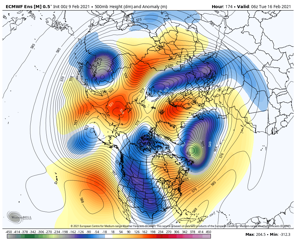


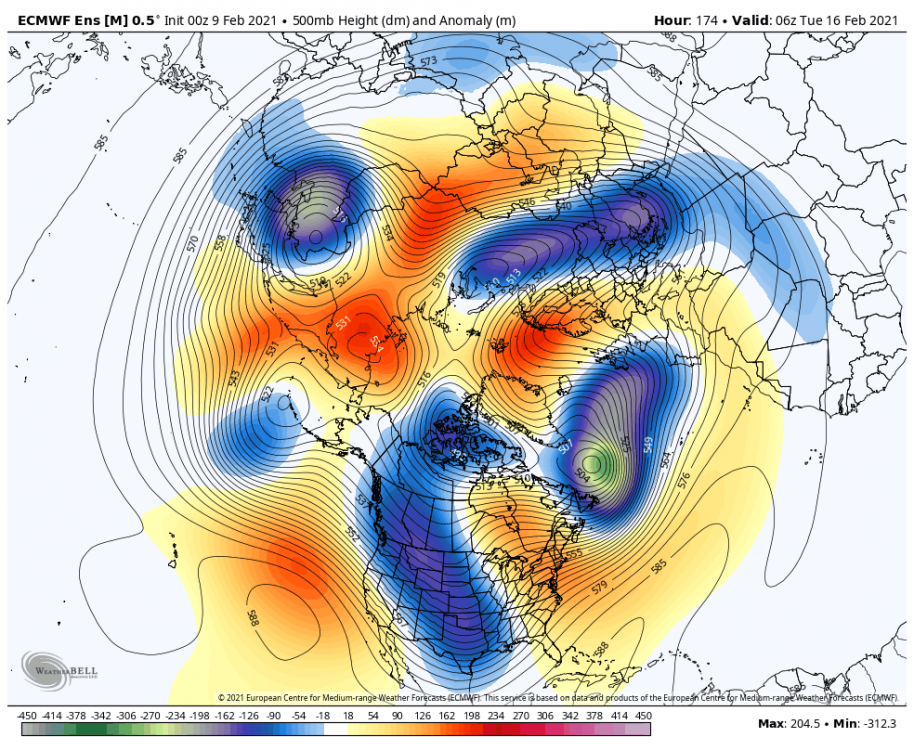
February 10-12, 2021 Winter Event
in Mid Atlantic
Posted
The snow map is def wonky. I’m seeing temps on the para of about 32-33 in the northern half of the district at least. Hoping that that might be at least good for 1-2 inches of snow/sleet.