

chris21
-
Posts
538 -
Joined
-
Last visited
Content Type
Profiles
Blogs
Forums
American Weather
Media Demo
Store
Gallery
Posts posted by chris21
-
-
Low position is significantly further north at 105.
-
3 minutes ago, jviper said:
This is reality. - “ 1) we've all been headfaked in years past with epic pattern looks that end up verifying for 12 hours then revert back to the sos“
While very true, this pattern has already dropped ten inches of snow on dc one week into January.
-
 4
4
-
 1
1
-
-
1 minute ago, Jersey Andrew said:
Climate change has to be playing a significant role. How many blockbuster snowstorms from 2006 onward up and down the Northeast? I would be interested in any comparisons to 1995-1996 winter which also flipped like a switch in early January after a warm November and December.
Nov/Dec 95 were relatively cold as well.
-
2
-
-
4 minutes ago, dallen7908 said:
Good point - bad post by me. Why is the 12z GFS a dream in the extended? Verbatim, most of our area gets ~1" of snow during the next 384 hours. I assume you like the upper air pattern etc.
again, I’m not sure you’re looking at the latest 12z GFS run. I see far more than an inch accumulated in the next 384 hours and no fewer than three distinct threats with cold air entrenched essentially throughout the run.
-
10 minutes ago, dallen7908 said:
Where did all of our model snow go? Clockwise from upper left (18 UT yesterday, 00 UT today, 06 UT today, 12 UT today) Through 12 UT next Friday; GFS
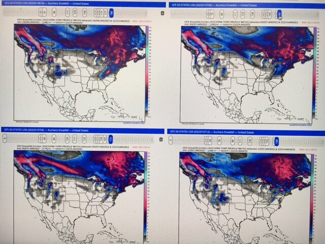
Are we looking at the same weather model? The 12z GFS is a dream in the extended. All of that snow predicted on the first two frames fell yesterday.
-
1
-
-
5 minutes ago, gunny23 said:
we have 4 wheel drive and both from New England - we will take it slow. we've been going out there for years so know what's ahead
Awesome! Enjoy, check out hellbenders and stumptown while you are there. @jonjon
-
6 minutes ago, gunny23 said:
Just packed the car - screw it - I don't care how dicey the drive is, we are heading out to Canaan. I am not missing this
As someone who used to live out there and goes several times a year… if you have four wheel drive and you’re experienced in driving in the snow you’ll be fine (the visibility will be zero without a doubt once you climb Mt. Storm and summit the Allegheny plateau). If not you will have serious issues because the snow will be very deep on corridor H.
-
2
-
-
The HRRR is seriously chasing convection (could be dead on). But it’s low track compared to the gfs is starkly different for -6 hours until snow starts falling.
-
1
-
-
6 minutes ago, Warm Nose said:
Dryslot pretty much eroding anything for E Tennessee. They'd projected 2-3".
I used to live in Asheville and near the Tennessee border in Jackson county, NC. East Tennessee is a really tough place to number one forecast snow and number two get snow. The mountains often break up much of the moisture or the moisture skips east or west. The valley locations are much drier than the mountaintops (much like western Colorado). At this point, I’d assume it’s snowing up high and raining or dry in the valleys but don’t think it matters much as far as sensible weather in the dmv.
-
1
-
 1
1
-
-
GFS still holding quite steady. Wow.
-
2 minutes ago, Interstate said:
Nobody look at the UKIE
It’s 12z run snow maps are a bit wonky. It depicts .2-.3 qpf with temps below freezing and little or no snow accumulation.
-
4 minutes ago, StormchaserChuck! said:
It actually misses north.. these maps are rarely wrong.
That map looks far far different on pivotal.
-
1 minute ago, pazzo83 said:
I'm downtown and my station bottomed out at 24.
Got down to 21 in adams Morgan close to rock creek park.
-
9 minutes ago, psuhoffman said:
We should have dismissed that just on the fact there are no comps. The only thing that came remotely close to what models were spitting out in Dec 2017 was PD2 but that wasn’t as long duration, did have a more concentrated system, and was in a Nina.
That ended up being an epic surprise storm for my current location at the time, Candler, NC (just west of Asheville). Forecast was for less than an inch and even though short range modeling picked up on a 2-4 deal at the last minute we ended up with 11-12 inches and then an inch or so of upslope that night with blowing snow and blizzard conditions.
-
2
-
-
22 minutes ago, baltosquid said:
We’re also due for eternal heartbreak!
Ha! That’s the only thing we’re not due for. Maybe 10 heartbreaks a year since 2016?
-
3
-
-
3 minutes ago, Maestrobjwa said:
Been trying to resist commenting on here lately, but I'm sure I'm not the only one feeling burned by last year's "no cold air around" -NAO...lol How would you compare this to last year?
It might not end up helping us much, but Canada is frigid this go around whereas last year Canada was almost completely above normal.
-
3
-
1
-
-
The 12z Ukie showing a large area of -30-45 degree departures in south central Canada at 144 including a couple -30 F readings. Pretty chilly for November...
-
Epic -NAO on the 12z gfs 200 hrs plus out. Upslope machine could be ramping up early this year.
-
3
-
-
10 minutes ago, Eskimo Joe said:
Yea the end of the run is just ugly. Lights out territory.
At least the ensembles don’t really support the op at all but yeah it’s ugly.
-
1
-
-
13 minutes ago, Prestige Worldwide said:
Ha, has the opposite at 12z. Wouldn't pay attention to 300 hours plus, massive flip flopping and struggles in the EPO region.
-
1
-
-
4 hours ago, CentralVaNATS said:
Fox 5 winter outlook. I thought first that there was going to be a coastal sometime this week. But it's for the entire season

Sent from my SM-G998U using Tapatalk
That would be the lowest all time snowfall total for Davis, WV by at least 40 inches. Extremely bold call there. Some of Tucker County is in the 10-20 inch zone.
-
35 minutes ago, PhineasC said:
Western MD, certainly. They average about 100" out there in some spots. Retention is bad, though. They get torched a lot.
If you go just a bit further south into Tucker County, average goes up to 150-160. Had a nice snow pack for essentially all of meteorological winter there last year.
-
14 hours ago, Maestrobjwa said:
Don't all ninas not named 95/96 pretty much turn out the same around here? (With 2017-18 nickel and dimed 18" total being the high end). See the other ENSO states have more "chaos"...but Ninas are, historically, frustratingly consistent. I don't think any other ENSO has a greater proportion of fails than ninas, lol
99-2000 was a decent nina. Pretty epic surprise snowstorm and several borderline events. 98-99 was also a nina that featured a major ice storm in January and another epic surprise snow in March along with a couple threats that just missed in March.
-
17 hours ago, WxUSAF said:
I am HERE for the 250-290hr 18z GFS. Stalling nor’easter with temps in the 40s. Deform band, pivot, it’s got it all. #atmosphericmemory
I'll be in Davis so I'm ALL IN
-
1
-
MLK 2022 Storm Potential
in Mid Atlantic
Posted
I’m down in Davis, 23 and light snow. Ridges have decent ice build. Light freezing rain at 24 degrees made the drive in on 48 pretty dicey.