

chris21
-
Posts
538 -
Joined
-
Last visited
Content Type
Profiles
Blogs
Forums
American Weather
Media Demo
Store
Gallery
Posts posted by chris21
-
-
2 minutes ago, Brett said:
New member to the forums here but I read that the advertised -NAO is going to be eastern based. Does that matter? A few people said it is not good to be eastern based?
An east based nao is not the greatest snow look in dec, but with shorter wavelengths it becomes less of an issue in March. West is still ideal always.
-
Just now, SomeguyfromTakomaPark said:
Has anyone been keeping tabs on how it ended up doing with the last few storms?
Did pretty well with the ice storm. Showed about .3-.4 qpf consistently and handled the shortwave pretty well I thought.
-
2 minutes ago, Always in Zugzwang said:
Yeah, not sure what the precise interplay is between temperatures and rates for ideal accretion, when below freezing. I'm sure the thermodynamics is a bit complicated when we start talking about those details. Of course, if it were 15 degrees and pouring rain, that would presumably be different than, say, 31 and doing the same.
Absolutely... heavy zr at 15 would be far more efficient at accretion than heavy zr at 31.
-
25 minutes ago, SomeguyfromTakomaPark said:
I was hoping for some drizzle/mist to cap this off but doesn’t appear to be happening tonight.
Some fz drizzle currently in NW.
-
29 minutes ago, WEATHER53 said:
7pm ovs
28.4 and very light snizzle
dont know if we are done and don’t have all the reports but this does not seem to have been an extreme event as forecasted
NWS has a preoccupation with freezing rain perhaps because it the most difficult situation for the public to handle safely , It’s is an unfortunate tread socially to portray “worst case” as “most likely” . Always scratched my head when their forecasts include”...for this afternoon rain or freezing rain likely with high of 40”
Being safe rather than sorry I can’t decry much but don’t think it is the best forecast method .
Actually it was far worse than forecast. At least here in NW DC. 27 degrees and falling.
-
4 minutes ago, 300 square feet said:
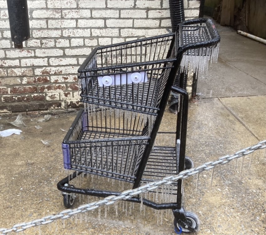
Just had a moderate burst that mixed in some sleet and even a few flakes, but otherwise a very steady freezing rain for several hours here in Petworth. Streets are starting to turn white
Same situation in Mt. Pleasant. Temp has ticked down once again to 28.
-
8 minutes ago, real said:
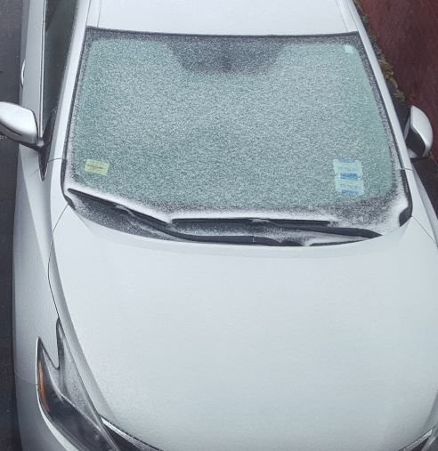
That is weird, because every car parked in the lowlands of DC is encased in thick ice.
Mt. Pleasant is def encased in ice!! 29 with sleet/freezing rain continuing. Huge NAM bust lol.
-
1 hour ago, WxMan1 said:
As many of us hinted last night...
Not a surprise at all. We have so many events, including the 3/16" of ice here with the last event after 2.5" of snow, where we get a glaze that sneaks up on us. There were far more glaring model signals going into this event however, including a steadfast ECMWF, that were screaming ISW.
I kept pointing that out but everyone told me it was going to be a “non-event”. Looked like a clear high impact event in dc to me at least.
-
 2
2
-
-
8 minutes ago, Pixee said:
Icing up now in Southeast DC. Cars have cover, some frosting on mulch and grass. Streets are half glaze/half wet. Steady at 32 degrees. Roads are gonna get ugly. News reports of an overturned concrete truck at a SE gas station. Friend of mine at the hospital for falling on ice.
Wow, 28 up here in NW. moderate sleet and freezing rain.
-
3 minutes ago, BristowWx said:
I didn’t realize this was supposed to end so soon. Back edge already? Wow
Precip looks to be redeveloping on nexrad. Looks like a couple more hours of precip prob. Unless temps rise, conditions will continue to deteriorate as the sun begins to fall.
-
2 minutes ago, WxMan1 said:
Freezing rain here in Crofton, 28°/23°.
As I mentioned yesterday, the forecast *still* has us getting to 37°F tomorrow. With no horizontal temperature advection and a bolstered in-situ CAD setup with all that sleet and ice to melt (diabatic cooling), I have no idea when we'll hit the freezing mark again. Monday perhaps?
With a light ne flow at the surface and really a classic cold air damming look I’ve been wondering the same thing....
-
1
-
-
1 minute ago, LP08 said:
Do you think also that it’s raining to hard to get the accrual on everything? I never expected the roads to be bad but expected the trees and such to be icier.
I think accrual will gradually catch up if the temp does not budge much. Tonight is supposed to be only around 27-28. I just don’t see how all of this doesn’t freeze given past similar situations.
-
2
-
-
2 minutes ago, EHoffman said:
Light rain, pavement wet, don't really even see much accrual on branches or elevated surfaces.
Oh man... the sidewalk in front of my house is straight ice in mt. Pleasant. The temp fell to 27 also... don’t think that bodes too well looking at the radar.
-
Sidewalk has caved in nw... sheet of ice. Temp has ticked down 27/23 with freezing rain and an occasional sleet pellet.
-
1
-
-
9 minutes ago, CAPE said:
Unless temps drop some, the mid Feb sun radiating through the clouds should mitigate it somewhat. This evening and overnight would pose a bigger risk.
Not helping much at all in dc now but our temps are a bit lower... 27/28.
-
11 minutes ago, Weather Will said:
WB 12Z 3K NAM


Already a bust in dc. I thought the NAM was king! lol, this winter....
-
2
-
-
The 00z UKMET went with the euro progression... mostly snow and sleet for the thursday storm.
-
 1
1
-
-
Sleet/Zr just started in Mt. Pleasant, DC. 30/22. Unfortunately more zr than sleet. Radar actually looks rather robust, euro may have been on to something but we shall see.
-
Just now, CAPE said:
I think we are right in the middle of our epic period now.
The level of epicness is difficult to put into words.
I’ll try... not great but wayyy better than last year. At least Utah isn’t the closest location to find snow to snowboard on.
-
3 minutes ago, Weather Will said:
WB 6Z EURO. Looks like it moves into DC proper by mid morning and then into north and east suburbs by 1 pm. Out of here in NE burbs by 8 or so.


If nothing else... after somewhat insane run to run changes prior to our last few events... the euro has been remarkably consistent the past four runs with this event depicting between .38 and .44 qpf as freezing rain.
-
1 hour ago, jewell2188 said:
Balmy 32 degrees in chantilly
Hmm. It’s 29 in NW DC.
-
1 minute ago, yoda said:
Wouldn't be surprised if we see ISW appear in i95 corridor if 00z models look like 00z NAM
RGEM looks identical if not a bit wetter than the 00z NAM.
-
1
-
-
1 minute ago, real said:
Steady light snow in Downtown DC. -- First hints of becoming a car topper.
Car topper in mt. Pleasant! 30/22.
-
2
-
-
18z euro continues to depict a nasty ice storm with no sleet and .38 inch of freezing rain in dc, essentially the same solution as 12z.
-
1
-
 1
1
-


Feb Long Range Discussion (Day 3 and beyond) - MERGED
in Mid Atlantic
Posted
Yeah, if you look at the strength and location of the high and arctic air nearby and light northeast flow it’s actually a classic situation for a major ice event in dc. Def doesn’t look like an all snow event in dc, but I would certainly not sleep on the sleet/ice potential with this storm given the synoptic setup.