

chris21
-
Posts
538 -
Joined
-
Last visited
Content Type
Profiles
Blogs
Forums
American Weather
Media Demo
Store
Gallery
Posts posted by chris21
-
-
6 minutes ago, nw baltimore wx said:
Anne Arundel students finished on June 24. They go back August 29.
Pathetic “summer.”
On topic, nice day and fingers crossed for a thunderstorm later.
Same in PG county. Glad I made a switch from classroom teaching to tutoring full time… shortest summer I’ve ever seen.
-
5 minutes ago, 09-10 analogy said:
Possibly “patchy frost” out in the mountains this weekend according to the latest AFD. When was the last time that may have happened on mid June around here?
Depends where in the mountains. In Canaan valley, frost is pretty common into July and August, other places not so much.
-
 2
2
-
-
Impressive constant lightning to my west from the porch here in adams Morgan.
-
1
-
-
6 minutes ago, Baltimorewx said:
This is the concern for lower elevation areas…just takes longer for the column to be completely supportive
31 in NW DC now.
-
2 minutes ago, stormtracker said:
18z to my eyes looks slightly colder and wetter. These are SV maps, so who knows..but its an improvement if these maps match up
Its def an improvement on pivotal. Colder, wetter for sure.
-
2
-
 1
1
-
-
6 minutes ago, osfan24 said:
Looks like it just shifted the heavy band from over the metros to out toward the Catoctins.
Heaviest qpf still over the metros and se. Better temps north and west. Looks like noise at this point.
-
4 minutes ago, SLPressure said:
The HRRR doesn't have DCA falling below 33. A lot of the total snowfall depicted is not what is going to be accumulating.
Does DCA ever fall below 33? I’d imagine in that scenario the city would be 31-32 at nighttime. Been burned by low level warmth many times in the district but hopefully this event occurring at night will help our cause.
-
11 minutes ago, Wonderdog said:
To my untrained eye, the entire run appears to have no western ridge that works for us.
Has a wicked arctic frontal passage that will certainly not happen as advertised around hour 200.
-
Nice trailing wave with plenty of arctic air around, reminds me a bit of 1/3
-
2
-
-
Potomac River was frozen from bank to bank this morning at Georgetown.
-
8
-
-
GFS def tripled down there
-
2
-
-
Euro still made a significant shift south. At this point, that's all I'm looking for.
-
3
-
-
CIPS analogs highlighting several historic ice storm analogs including the Jan 99 storm which was particularly damaging.
-
1
-
-
5 minutes ago, Imgoinhungry said:
GFS has significant ice for areas NW starting around 6am. Legit or no? Dont think freezing rain will be an issue due to surface temps. Sleet that melts on contact?
I see surface temps quickly dipping into the mid 20s on the GFS. In that case everything would stick no matter how warm it was prior.
-
1
-
1
-
-
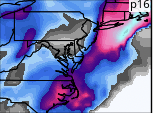
12z Ukie is a nice hit for the entire area on Thursday. Canadian appears to be trying to push the boundary south.
-
6
-
-
It’s better than the 06z run so far from what I’m seeing.
-
 1
1
-
-
1 minute ago, Yeoman said:
Lock it up
Quality post
-
Mesos look pretty juiced for the 95 corridor. A general 2-4 across all of them.
-
Still coming down in Davis with blowing snow significantly reducing visibility. Has been snowing for nearly 48 hours straight.
-
2
-
-
Still pouring snow in davis. Blizzard conditions continue with maybe 18-19 inches of snow but really difficult to tell. The drifts are really impressive… at least 4-5 feet, some prob higher.
-
6
-
-
8 minutes ago, SomeguyfromTakomaPark said:
The webcams from whitegrass in Canaan valley are showing an absolute blizzard right now.
Can confirm! I'm about three miles north of whitegrass and conditions have shockingly worsened (considering it was already a whiteout) over the past few hours. Vis is maybe 50-75 yards. I'll try to attach some pics in bit.
-
2
-
-
Light to moderate snow In Davis at 20 degrees. Sleet mixed in for about an hour earlier this evening but has changed back. The wind has been fierce all night with significant blowing and drifting of snow. 2 foot plus drifts pretty common.
-
3
-
-
Blizzard conditions in Davis with heavy snow. Gusting to at least 35-40. Wind has really picked up recently. Temp around 19.
at least 5 inches of new snow but tough to tell with the drifting.
-
6
-
-
12 minutes ago, nj2va said:
Nice man, enjoy the storm. I’m starting to think the mountains will get more snow Monday AM into Tuesday AM from upslope than the WAA portion. That strong of a LP with the NW winds will really crank the upslope. Regardless should be a fun Sunday and Monday. Glad you got there safely.
Thanks man. We’ll be interesting to see the differences between davis and deep creek. Pretty wide variety of possibilities still at this point.
-
1
-
Hurricane Nicole
in Tropical Headquarters
Posted
Gusts to 40-45 near Jax Naval. Pretty wild already a couple blocks from the St. John’s.