

chris21
-
Posts
538 -
Joined
-
Last visited
Content Type
Profiles
Blogs
Forums
American Weather
Media Demo
Store
Gallery
Posts posted by chris21
-
-
5 minutes ago, clskinsfan said:
In all seriousness. Look at this panel. Then go look at the radar down in the TN area. The HRRR is clearly underdoing that precip. May mean nothing. But we'll see.

If you look at the total qpf panels from the short range models and the nam nest, it looks like even at 18z they average just under a tenth inch of qpf basically areawide (ice/snow) overnight. Def a misty/freezing drizzle type look either way.
-
 3
3
-
-
3 minutes ago, jaydreb said:
It’s weird. The GFS-Para jacks the DC metro area with precip. The Euro has the same area as a precip hole.
Def not a precip hole in the slightest. DC actually has more qpf than regions to the north. It is more sleet than snow on the euro however.
Edit: I see you said snow hole! No argument there -
GFS and Para hold serve with 3-6 inches for the cities before sleet and then freezing rain. Still printing out over an inch of frozen qpf with temps in the 20s.
-
4 minutes ago, mappy said:
FWIW, Ava did mention that those along the bay would see very little in the way of snow accumulation before the flip to sleet, and possibly 33 and rain.
Looking at the high location and strength of the wedge across the models... I’d doubt Annapolis sees 33 and rain. Solomons Island? My former alma mater St. Mary’s? Absolutely
-
1
-
-
2 minutes ago, Ji said:
i think the 6z run was better
I’ll take the 12z in DC... over 1 inch qpf of snow/sleet by 18z.
-
1
-
-
1 minute ago, osfan24 said:
Well it was out of its generally useful range at that point, but it still was never as cold as the other models. Like one of the mets on here said, sometimes it can throw up red flags with temperatures.
I see temps between 25-28 for the duration of the storm in dc-Balt on the 06z NAM
-
1
-
-
Just now, ErinInTheSky said:
Wait what?
The NAM has been showing, consistently since the first run at range, that the Sleet line will be well into Maryland very early.
The Euro, GFS, etc have shown on the other hand have been, even as early as yesterday, putting out sleet lines in Virginia and dropping 8+" of snow region wide. Don't even get me started at what the Euro and GFS were saying when the NAM was "at range".
The NAM has been great IMO, it was great on other storms and in this case, it looks like models are caving towards the NAM here as well.
NAM was terrible with the ice storm. Let’s see what the models have to say today... still over 18 hours from the event with plenty of divergence from models. Not sure we can make definitive statements about how this storm will turn out yet.
-
3 minutes ago, psuhoffman said:
It’s not even trending north. It’s trending warmer. It’s still a perfect track with an Arctic high in place. Dunno what to say.
Still looks real cold at the surface... do you mean upstairs?
-
06z Euro is still a high impact winter storm with very cold temps. Just more sleet and some freezing rain in dc rather than snow. This time it won’t be rain...
-
1
-
-
33 minutes ago, Baltimorewx said:
Outside of that crazy para run the overnight runs including 6z’s seemed like a step back to me in terms of snow and the initial thump and a quicker transition to sleet. Hopefully they go towards a little more snowier solution at 12z here
00z Euro was better for snow over the dc-Balt area.
-
1
-
-
2 minutes ago, Eskimo Joe said:
Hush. Never doubt the ability of something to pull the football away last minute.
Lol! Absolutely true in the dc region. Luckily we are essentially within 36 hours and every hour that ticks by without a sudden shift makes that less likely.
-
10 minutes ago, Baltimorewx said:
Looks like N&W is likely to do a lot better than I95 and the cities though with whatever falls thursday evening/night...data seems to want to kind of dry slot cities and keep the party going with bands N&W...believable since weve seen that story before
You could always say that and be right 90 percent of the time. However, doubt the models have the placement of the Thursday night precip locked down 48 hours in advance when they just started showing wraparound precip for the first time 12 hours ago.
-
1
-
 1
1
-
-
1 minute ago, flsch22 said:
Agree with weighing seasonal trends. This is looking very familiar to the 1st storm of the winter (way back in mid-December) for my backyard. 1-2 inches of snow then a mess. Probably less rain this time which would be an improvement.
Looks really different from the dec storm... what are the similarities?
-
3 minutes ago, jewell2188 said:
Posted by a met on Twitter, 110% valid point. Why go against the seasonal trend and that has been a rug pull at the last minute.
That’s just the nws discussion from lwx. Pretty sure they will lift watches with the afternoon package given the 12z runs.
-
3
-
-
2 minutes ago, EHoffman said:
Don't worry a million people yesterday told me it doesn't matter and DC readily accumulates sleet during the daytime.
If the temps are in the 20s it certainly will. On March 9th, 1999, the streets of dc were covered in over 7 inches of snow from a daytime event in mid March. How would you explain that?
-
Just now, Ji said:
every storm ends up being something where we see the back edge before the first flakes. Its super annoying. I am hoping the NAMS are still out of their range
How about the three day storm less than three weeks ago?
-
2
-
 2
2
-
-
2 minutes ago, IronTy said:
Not sure, the QPF is lower and this smells like the inevitable drying trend as the storm nears in.
There’s no doubt there is more snow in the initial thump in dc at least than 00z... check the soundings..Held steady with qpf in the dc metro.
-
Just now, gopper said:
They need one of those graphics for days 1-2 to clear up confusion.
Check out their snowfall accumulation maps.
-
1 minute ago, IronTy said:

For those keeping track... this a far better run snow wise than 00z for the dc metro at least.
-
2
-
-
5 minutes ago, CAPE said:
SREFs look just like the NAM.
pick your emote.


Hope they start trending toward the globals but have they ever not been amped and north? It’s anecdotal but I feel like anytime there is a southern slider we can at least count on the srefs to throw us .50 of digital qpf when everything else is dry.
-
1
-
-
8 minutes ago, Hypothetical 240 hour snow said:
This storm has Virginia special written all over it... congrats, to be fair we got our snow last week.
Suppression fail crew has already taken the 00z shift away from the warm fail crew.
-
1
-
2
-
-
Just now, Imgoinhungry said:
Too bad it is the euro and it has been dreadful all season!
Was on a terrible streak but nailed the ice storm from impressive range and consistency.
-
5 minutes ago, EHoffman said:
We always fail in borderline scenarios in mid-to-late February like this, yes. It's very rare we actually cash on a frozen-to-rain scenario like this.
I wouldn't call 2 days ago high-impact in DC at all. In fact, we avoided high impact by being a huge heat island and not having ZR accumulate anywhere for hours when it was 29 degrees because of the sun angle. It's a good example of why it's sooooo hard for us to bank in borderline scenarios.
Strongly disagree, could barely walk outside my house Saturday and sat night. It didn’t accumulate anywhere? NWS reported a .25 inch ice in adams Morgan.
-
2
-
-
4 minutes ago, EHoffman said:
Yes I do think SOME of the precip will fall frozen in DC. I just don't think there will be a signficant/any impact in the city. We are always too warm, we always switch over earlier than anticipated in these types of systems, and we're always too cold on the globals at this time frame. This is how DC weather works in the winter.
Ehhh... happens a lot... but we just had a high impact freezing rain event two days ago that was apparently “impossible in dc” even though I’ve seen it many times.

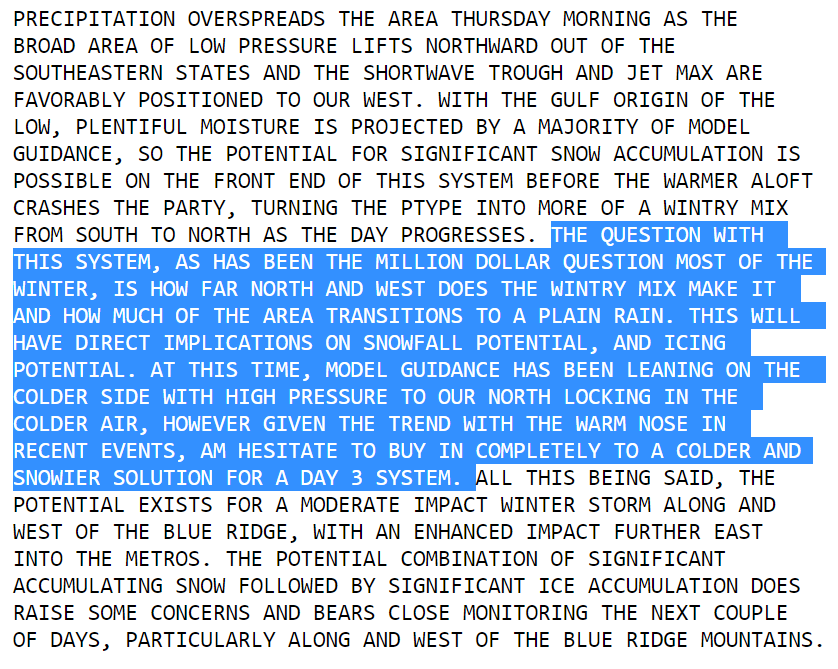
Feb 18/19 Disco/Obs
in Mid Atlantic
Posted
They tried to plow my street in dc (there is a fire station on our street) and failed miserably. Honestly they just made it worse.