

chris21
-
Posts
538 -
Joined
-
Last visited
Content Type
Profiles
Blogs
Forums
American Weather
Media Demo
Store
Gallery
Posts posted by chris21
-
-
45 minutes ago, WEATHER53 said:
My forecasts of problems around and within 15-20 miles of DC stemmed from this analog method
NEVER since 1975 has my station nor DCA EVER received 4” of more of snow when the daytime temperatures before the even have hit or exceeded 48F. Such an air mass has never supported that amount of snow. A few (3/4) had instances where a cold front moved thru after the 48 was hit or exceeded but that was Not the case in this situation
Feb 87... was one
-
3 minutes ago, DCTeacherman said:
This should probably go in banter....but does anyone know if there are weenies in Europe? I wonder if there is an EU equivalent of this site. I wonder which country has the biggest snow weenies. So many questions. Is Russia their equivalent of New England?
There are tons of weenies in Europe. They are all over Twitter!
-
 2
2
-
-
Just now, real said:
I'd be shocked if DCA ends up reporting even a half-inch. Probably just a trace over there, which should put us well on-our-way to having a below-average season for snowfall. Normal for this point in the year is 9.8. Before today, DCA was at 3.5
Damn, I have more than twice that in NW...
-
All snow in NW DC. Starting to accumulate quickly. Temp down to 33 and falling.
-
2
-
-
5 minutes ago, MDRandy said:
Just like last week when model consensus at this time consistently showed double digit totals up and down 95.
I don’t think all of the models were slightly southeast of bulls eyeing the I-95 corridor from 36-40 hours out but maybe I wasn’t paying attention that close.
-
11 minutes ago, MDRandy said:
One more tick NW - probably tonight or tomorrow - and the 95 corridor is just a rain/snow mix. This looks like a 81 corridor special
Sweet meteorological reasoning there
-
Just now, LP08 said:
Trimmed some of the NW extent of the precip however, thought everything trended a little better but really confines the heavy precip east.
I really don’t mind that look sitting in dc 36 hours out... I would imagine given the lack of suppressing flow there could be a tick or two north and west prior to Sunday.
-
2
-
-
1 hour ago, mappy said:
then feel free to hug the weenie snow maps
")
Def wasn't saying that either. Just relating my experience with that one product. Think you already mentioned it but looking at the different parameters, etc... prob the best way to go.
-
1
-
-
8 minutes ago, mappy said:
snow depth is probably the better one to use.
The snow depth map could be right, but in general I have found that product to be pretty atrocious with verification.
-
5 minutes ago, ovechkin said:
Serious question from a novice and my apologies in advance for my ignorance.
I see what the models are projecting, and get there will be low dews and can calculate a wet bulb. Yet, with temps on Saturday around 50 during the day, clouding up during the evening, and the inability in the immediate metro to cool down even to forcasted lows most nights (supposed to be 35 last night and never dropped below 40, and even last Friday night during the “very cold” stretch barely ducked under 25,) how will this ever be cold enough to support accumulating snow? I have seen dynaimc heavy snow accumulate at 34-35. I get it. But how can we be sure it won’t be just cloudy at 42 heading into the event in the immediate metro? Is just robust dynamic cooling? Again, sorry if this a stupid question.Where are you located in DC? I got down to 36.7 last night in NW, you didn’t get below 40. Luckily, it’s early Feb so we are in prime climo for these types of events. I would be far more worried about what you are referring to of this event was in March. Most of the models indicate heavy precipitation with cold air aloft creating an ideal situation for dynamic cooling. Most models show temps of 31-33 during the heavy snow.
-
Still have full coverage in my yard in nw. Hard to keep snowcover downtown.
-
19 minutes ago, high risk said:
Yeah, this morning's AFD from LWX is NOT aging well.....
It’s aging about as well as this 1990 CSN album cover. Additionally in the afternoon update, the forecast indicates a 20 percent chance of snow. In the AFD, they also day all terminals can expect ifr conditions in wintry weather sat night and Sunday. Which one is it?
-
 2
2
-
-
Just now, WxUSAF said:
I have no memory of that Feb 2-3, 2010 event. I remember the Jan 30 event very well, loved it.
I remember the 2-3 event well. 4 inches or so in Bethesda with maybe 3 in upper NW. came down heavily for a while but wasn’t that cold.
-
6 minutes ago, HighStakes said:
Waiting for Amped to bring out the Feb. 87 analog. Marginal temps, fast moving and nice juiced up system.
87 has been showing up in the 6-10, 8-14 day analog list.
-
1
-
-
1 minute ago, LP08 said:
Definitely. Looks like some of our storms where we near the city post obs that it’s 45/34 waiting for precip to arrive.
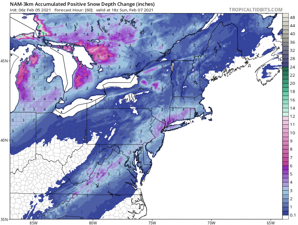
Hopefully it comes down hot and heavy. Even the positive snow depth change map shows 5 in DC, but temps aren’t great and we know how that can go.
-
3 minutes ago, CAPE said:
lol I was just having a bit of fun at your expense.
I know my climo here, and what is ideal for my yard is not necessarily what you want to see, but it is not all that rare either. Long term avg snowfall here is higher than DC, at 18.5".
There are many times I have gotten moderate or even significant snow that have left places NW of I-95 high and dry. Happened in Jan of 2017 and 18 most recently. Both of those events had legit cold air in place. That tends to even things out a bit, because clearly being further inland is better much of the time.
I know this has been hashed and rehashed but the long term avg at DCA is not really representative of even downtown though. NW DC is prob closer to 20. For instance, in this past storm I measured 5.5 inches while DCA measured 3.2. In 2016, there was a uniform 23-26 inches in NW, while DCA recorded 16.
-
15 minutes ago, DCTeacherman said:
HRRR and 3k don’t have this feature at all. Fun!
HRRR has been particularly atrocious with this storm in the dc area.
-
I haven’t checked the board since the 18z runs went north on Saturday. But to be honest, in NW DC, this has been a legit storm (that also shattered the myth that freezing rain can’t accumulate on dc roads).Just measured about 2 inches new since late last night, 4.5-5 total so far. This is why we track!
-
2
-
-
Just now, Weather Will said:
Just trying to be factual. If there is a model showing anything from the coastal tomorrow, please post it. Looks like a nothing burger for most of us.
Lol, he just did!
-
1
-
-
Just now, MillvilleWx said:
Couldn't agree more. This will be a rapidly developing cyclone with intense 7H dynamics as shown by models for several days now. You're going to have snowballs falling from the sky considering the massive lift across the region. CCB love is so hard to fully pin down, and the GFS/CMC also had a bit of a TROWAL signature on Monday night as the storm begins to occlude. I'd love to see the theta-E analysis and satellite when it gets to that time. Wish I was home for this one man. Cheers to large fatties falling while ripping a few fatties
")
Sounds like a good plan all around!
-
1
-
-
43 minutes ago, dailylurker said:
It's not enjoyable when you know it's all getting washed away in a few hours. At least for me it's not.
Not sure that’s what’s being modeled other than on the gfs and even on the gfs, the thermals are getting colder as we approach the event.
-
1
-
-
CcB looks good into the cities on the 06z euro.
-
18 minutes ago, Deck Pic said:
1/16/03 is an example....super cold...under a warning and the storm just colossally shit the bed and dried up. maybe like 0.5"....so many disasters, I could post about them all night...but I won't...good vibes
I remember that one really well. Those were the Wright weather days. I was a senior in high school and stayed out drinking... long story short two hour delay. If I remember it was trending worse and worse and was supposed to be a 3-6 inch deal.
-
1
-
-
1 minute ago, osfan24 said:
Woof. Those two pictures tell the whole story. She gone. Next.
We are still looking at our first meaningful snowfall in two years in a La Niña. I’ll take it...
-
2
-

Feb Long Range Discussion (Day 3 and beyond) - MERGED
in Mid Atlantic
Posted
Excellent post.... also... if you lived near the dc metro and esp south and southeast, prob shouldn’t have had your hopes up for a huge event...