

chris21
-
Posts
538 -
Joined
-
Last visited
Content Type
Profiles
Blogs
Forums
American Weather
Media Demo
Store
Gallery
Posts posted by chris21
-
-
20 minutes ago, nj2va said:
I was just about to say that we can't deny that we just keep punting threat windows and can't seem to get legit threats within 10 days. Delayed usually means denied around here but its hard for me to wrap my head around we don't at least get a warning event with that type of -NAO/50-50 look. If we don't score, then all bets are off the table with what it takes to get snow around here.
In DC, we’ve actually had worse snow droughts. Look at the period from 1926-1932 . That being said, it’s still quite discouraging.
-
22 minutes ago, snowman19 said:
Yea, there may be a small, transient window at the end of the month. Beyond that, going into February, we will be riding a line very close to a full on torch pattern as the main tropical convective forcing moves to the Maritime Continent, if we lose the -NAO/-AO and they both look to be rising in the final days of this month, it’s hello SE Ridge, torch city
Guidance has tried to break down the blocking countless times in the past month and a half. Given previous similar blocking regimes, it usually does not just disappear... particularly after a coupled SSW. -PMM may affect the STJ but we may be heading toward a more favorable MJO by the time Feb rolls around.
-
 1
1
-
-
4 minutes ago, Ji said:
our only hope is the models dont really see this stuff clearly until 120-144 hours out. Then it starts looking more favorable. The PD storm in 03 was actually mainly a rain event on the models for a while
Yeah, I wouldn’t get too depressed about that look on the gfs op at 200 hours plus. The features would only need to shift slightly for a significantly different outcome. Not impossible 200 hours out on an op.I’d rather it showed blue... but still.
-
2 minutes ago, MocoMike said:
Does the SER ahead of this system keep it from being suppressed? When I look at this, I think it is going to cut. Thoughts?

Pretty stout west based neg nao doing it’s thing there.
-
16 minutes ago, bluewave said:
Yeah, looks like a very fast flow across the Northern Tier. The -PNA trough drops into the West with the 50/50 trough to our east. So storm spacing and late developing Miller Bs could be an issue. The EPS late January forecast is hinting at this.


I’ll take my chances with colder air and that beautiful west based block and -EPO.
-
1
-
-
12 minutes ago, frd said:
Canada still above, still awaiting a change, maybe by the end of Jan.

It’s a fair amount cooler than it has been recently however so there’s that.
-
Just now, WinterWxLuvr said:
That has cutter/jumper written all over it imo.
I’ll take that look all day and on Sunday. Overrunning galore. We might miss out on a couple Miller b’s but at least it will be active with the potential for something to travel under the block.
-
3
-
-
12 minutes ago, losetoa6 said:
Early lunch today . CMC gets CF snow nw . Lots of hints of this scenario. Might have legs

GFS looks good!
-
11 minutes ago, cbmclean said:
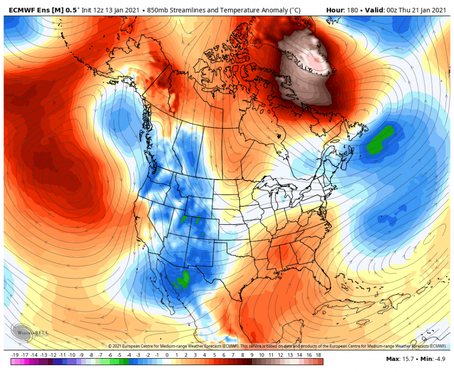
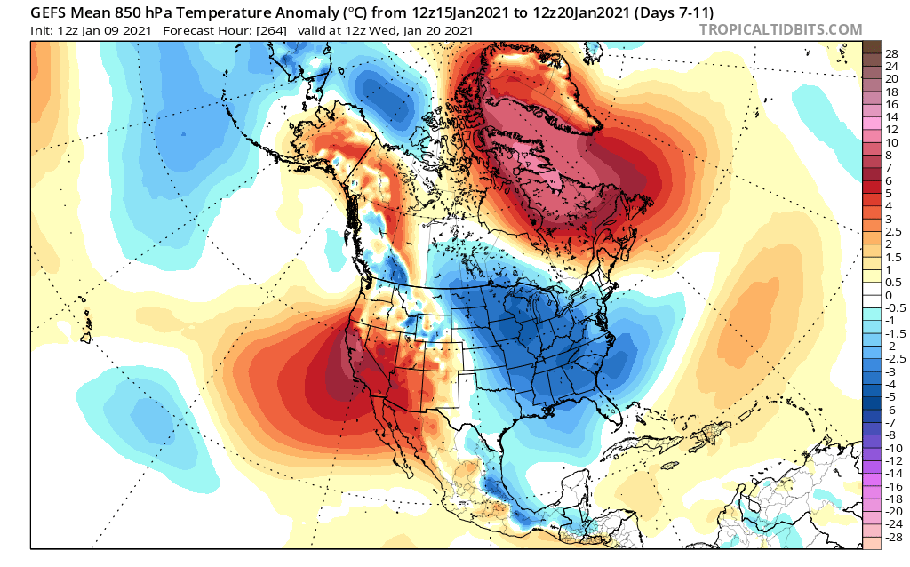
GEFS 850 MB temp anomalies still look to improve considerably after Jan 16, both for us and for our source region. 2m anomalies are disappointing though.

While they could be right for the wrong reasons I would tend to just look at the 850 mb anomalies. The long range 2m temp anomalies are atrocious to say the least.
-
Just now, frd said:
Or simply if the great pattern ends up being a week versus several weeks.
As Isotherm stated, it sounds like the best opportunity is later this month, and then maybe March.
Isotherm was more optimistic than I expected for sure.
-
4 minutes ago, Ji said:
thats exactly what i wanted to know. She is looking at Mooresville...and it looks like that is about 1.5 hours away from Booone/Beach. Closer than Western MD from my house now. Is it tough to get up there with terrain,etc?
If you are experienced with driving in snow in the mountains you’ll be fine. I was probably more adventurous than I should have been in my Camry but I never had any issues even in blizzard conditions. I will say that I lived near snowshoe for a couple years so Im relatively experienced with it. Even though it’s in the south, the counties to the north and west of Asheville average enough snow (between 40-90 inches) to be mostly on the ball with road clearing operations.
-
1
-
-
Just now, BristowWx said:
Their average is I think 10 inches. DC is what maybe 13 or so. I think it’s a wash with the elevation giving Asheville the edge. And less traffic
They have a tiny amount of big years and the average temps are warmer. I’m thinking more about NW DC/Bethesda climo than DCA. Most of their snow comes from 1 inch upslope events that melt within hours. Those same events dump lots of snow up high though.
-
14 minutes ago, Ji said:
my wife wants to move to NC---i know i will never see snow again if that happens but is it easy to drive to Beach Mountain?
Im looking at places in Roan, Beech and Boone. My gf is surprisingly ok with the 3500’ requirement so I’m going all in. If you live in Asheville it’s unbelievably easy to chase snow. Most spots are 20-30 minutes from decent upslope locations. The city itself normally misses out.
-
1
-
-
20 minutes ago, MD Snow said:
Also, I think the reason the cities haven't had any real snow is not because of some new normal. I think it's just been a ridiculous amount of bad luck so far. I know that's not a scientific answer. However, it is snowing in areas of Tennessee, Kentucky, North Carolina and Virginia today. Yes, even in this crap airmass. We just haven't had any real threats recently and the one's we've had have literally been 50-100 miles away from being huge hits.
This line of thinking has kind of kept me sane over the past couple winters. At some point, we will get lucky. At some point we will get the big dog. Until then I try to be at peace that I live just south of Baltimore near the bay and any snow I receive is a bonus and not a guarantee.
I used to live in Asheville and although there is elevation it is def less snowy than DC. They are def getting somewhat lucky so far.
-
7 minutes ago, George BM said:
I don't remember an April snow event in 2006. Do you mean 2007? It snowed during the early morning hours on April 7, 2007 and IIRC areas to the south got more snow than DC proper. I'm not entirely sure if anyone saw rates like that though.
It was 2007! My senior year of college at St. Mary’s.
-
1
-
-
2 hours ago, George BM said:
Yeah. Our standards are pretty low here in general.

Once in a while we luck into more legit convective snow showers like on February 9, 2017, ... April 9, 2016 from NVA into SMD, ...and, of course, the favorite recent convective snow event in these parts... February 14, 2015.
I'd love more than anything to experience a January 25, 1985 event here.
Did you mean April 9, 2006? In Ridge, MD (a couple miles north of point lookout) there was 4-5 slushy inches in a short time period with crazy heavy snow. It was unbelievably cold for April also so piles and patches of it could be seen for 4 more days making it a real unusual landscape for far Southern Maryland in mid April.
-
1 hour ago, WEATHER53 said:
Delayed but not denied is an excuse laden fallacy and I declared we were in trouble when it started up. This is about projected storm #7 with one of them sort of confirming. Apparently the vendors who buy the product are satisfied with a 14% confirmation rate. One of these will hit before the flip to constant warmth between 1/15-1/20. It’s actually been generally chilly for Dec and Jan but just not cold enough and certainly not +5 to +10 blowtorch
Just so I’m clear. You are claiming that an undefined conglomerate of meteorologists forecasts were collectively precisely 14 percent wrong over an undefined time period. I’m just trying to follow your scientific logic here...
-
13 minutes ago, EastCoast NPZ said:
Best pattern since '96.
Feet and feet of blocking. We're all gonna be exhausted from shoveling all that pattern by April.
This post would prob make more sense in April. It’s only January 4th and the “best pattern since 96’” is still at least a week away. Other than 2009, there has almost always been a dearth of snow prior to January in the DC metro (at least in the past thirty years I’ve lived here).
-
24 minutes ago, IronTy said:
By quite a few metrics, Southern Maryland is already in the very northern range of "humid subtropical" climate. So we're probably ahead of the curve relative to the rest of the DMV. Just an ominous warning that this is what lies in store for most of the MA forum in the next decade....
I don’t want to give too much credence to this theory but I’ll say this. I lived in southern Maryland for 6-7 years between 2003 and 2009. I lived in Tall Timber’s, Lexington Park, St. Mary’s City, Ridge and Park Hall. Southern Maryland is muuuch warmer than the DC area in the Spring, Summer, Fall and Winter. The climo is terrible and humid and warm. Late fall is often warm and humid and storms that are a cold 4-6 inches in downtown dc are a touch of sleet to rain. We should prob try to be more aware of our climo and the fact that the climo in Martinsburg is drastically different than St. Mary’s City.
-
33 minutes ago, IronTy said:
I wouldn't bet on that..
I've long thought that this is how GW plays out. Initially there's a golden period of snowstorms as the warming oceans provide the energy but there's still enough cold on the playing field. We've seen that the past 10-20yrs around here and especially up into NE. Then as the background state continues to warm you start to lose the snow and end up with rain. This will be the case for a decade or so until the next phase as subtropical conditions continue to move north and winter as we know and love it ceases to exist.
I wish we'd just get to that point already so we didn't have to put up with all this cold rain anymore.
I know there is a lot of frustration in southern Maryland over not seeing snow recently. Obviously, the earth is warming... however, pretty sure we don’t transition into a “subtropical climate” in the next ten years. Also not sure we saw a “golden age of snowstorms”... just been the same situation as always... we tend to go on hot streaks and of course... cold streaks.
-
26 minutes ago, losetoa6 said:
Yep.low mid 20s typically normal overnight lows here in January .
But I was referring to the possible zrain event with temps leading up to precip start. RGEM was clearly coldest model and was correct. Will it make much difference with precip delayed to afternoon...not sure
Think he meant you should post your obs in the January thread!
-
1
-
 2
2
-
-
1 hour ago, PivotPoint said:
The tweet you posted from Webb is fine and well, by he says “Cold? Sure.” Then shows a 10-15 day ensemble mean of 500mb that, yea, has a great west based huge NAO and slight ridging. It is a good look. But people underestimate the issues that we “DC” folk have with temps. PSU cited a the December storm as “see, it was almost cold enough and it was only mid December”. And it actually kind of proves my point. DC got nothing from that. And the reason was partly track but mostly mid-levels could hang on and we were flooded with WAA because our airmass wasn’t stout enough. Fast forward, Jan and Feb should fix that issue, right? I mean, another moth of cold building up would be enough to help a marginal setup, one would assume. I’m making the point that the cold is there like we would typically expect, and what looks like a great 500 could be great for Winchester on west, even with a great block and confluence to the north. We’lol have to wait and see but this isn’t a “he knows more, he’s a met, you be quiet” type deal. My issue with temps and what the block has not allowed to happen “building of substantially cold air” I view as a potential factor rolling through even a “good” upper air look.
Not sure where you live in DC, but where I live in NW we had an inch and a half of snow and some ice after that. Actually not bad for a storm in December.
-
52 minutes ago, PivotPoint said:
Lesson learned from this year: stable and early in the season blocking can screw us... badly. The issue here for winter weather this season is simple. Our source region had no time to build up cold and the PAC has a mean trough look. Pretty simple actually. There’s other side dishes in there but the meat and potatoes is there is no cold within 2000 miles to our N/NW. -5, -10 temp anomalies in central Canada have people saying “that’s cold enough for snow”. Well, yes. For them though, not for us. By the time that airmass were to reach us it would be modified and mixed to the degree that it would not support snow down here in the mid Atlantic. The only way to help fox our source region this late in the game would be a SSWE, or perhaps an EPO ridge and +NAO combo that allows cold to build back up for 4-5 weeks, then we hope for a cold March. It’s becoming pretty clear to me that any major snow chances might be a real outside chance (again) this year. I think we’ll probably luck into some times front that has some trailing energy to allow enough cold drainage for snow, but there’s a real chance that NOVA/DC metro gets blanked. Even if it does snow I bet we have surface temp galore problems not having any juice behind an artic high or even a modified front. Not feeling warm and fuzzy about our chances through foreseeable future. Maybe mid feb-March will produce.
Im going with this guy over psu, HM, and Webb.
-
 1
1
-
-
38 minutes ago, nj2va said:
Snow is ripping right now at Deep Creek on my Ring cams. 8 degrees with a -4 WC. Can’t wait to get out there tomorrow.
Merry Christmas!
It’s ripping now here in Canaan as well! 6 degrees, -9 wind chill. Merry Christmas!
-
1
-
 1
1
-


January Discobs 2021
in Mid Atlantic
Posted
Hopefully, the 18z will bring it back!