

chris21
-
Posts
538 -
Joined
-
Last visited
Content Type
Profiles
Blogs
Forums
American Weather
Media Demo
Store
Gallery
Posts posted by chris21
-
-
1 minute ago, WinterWxLuvr said:
I think it’s usually too dry with WAA. Again just my opinion
That’s awesome, cause from the way I’m looking at it, the 6z euro shows a general 4-6 from a bit south of I-70 on south.
-
 2
2
-
-
8 minutes ago, clskinsfan said:
That is uncanny actually. Look at the surface maps not just the upper air maps. Crazy similar to the Euro.
It was just a lot warmer ahead of that one and it was early December so all the early dec all caveats applied. I would have taken that storm with a colder thermal profile.
-
1
-
-
Just now, DCTeacherman said:
On that link @NorthArlington101 posted it looks like it changes us all back to heavy snow Monday afternoon/evening which hangs around for a while.
CMC looks great.
-
2
-
-
1 minute ago, mattskiva said:
I would literally pay for a forum where only the mets could post - even though it would mean I couldn't post.
The amount of bad analysis from non mets is ... well, I was going to say stunning, but probably more accurate to say 'typical'.
Yeah lol, let the run play out. Clearly a far better run for us. If you don’t think so or claimed that it wasn’t you prob shouldn’t be posting analysis unfortunately.
-
2
-
-
12z GFS is clearly trending to the Euro/CMC idea. The coastal low is more fav than 6z.
-
 2
2
-
-
2 minutes ago, ovechkin said:
2/9-10, 2010 also had 20 inches of snow on the ground to start. I have no clue why but when we have snow already around it seems to alter systems. 96 had a clipper that turned into a 6 inch storm also with 2 feet on the ground.
If this thing now has a primary in Ohio and a transfer near Delaware we will be using a broom to sweep our 1-2 inches while NYC gets 18 incheso
That has little practical effect on snowstorms other than possibly maintaining a cooler temp leading up to the event.
-
2 minutes ago, MocoMike said:
0z v 6z


Just a bit slower I believe but I could be looking at it wrong.
-
3 minutes ago, MocoMike said:
I thought the thump looked more suppressed than 0z
The WAA is still ongoing at this point.
-
3
-
-
11 minutes ago, osfan24 said:
A clean 5-10 is a nice storm. This isn't that. I've seen storms like this before and they are garbage. You end up with hardly anything on the ground when it's over. Long duration with a front end followed by warming and rain to wash the first half away.
Yeah, 3-5 inches on the front end with temps in the upper 20s. Sounds exactly like this Mondays event. I’m going with osfan over psu here, all my chips are in.
-
1
-
 1
1
-
 2
2
-
1
-
-
Just now, LeesburgWx said:
At 00z tonight, are we only 72 hours out from the first flakes?
That’s the word on the street.
-
Just now, WxUSAF said:
Euro overdoes near-surface winds. Don't know why.
As a boater/fisherman I strongly concur. During tropical storms it throws out crazy winds inland also
-
Just now, JakkelWx said:
Doesn't the euro use data from Japan soundings as part of their data? Heard it somewhere
I’m def not an expert on this but I read that both the GFS and the Euro use data from Japan, but only the Euro uses government data from China and Russia.
-
Huge run incoming
-
2
-
-
Just now, BristowWx said:
Hope the Ukie is at least decent
It is
-
3
-
1
-
-
The analysis has been tragically bad so far at 12z. Hopefully this get cleared up with there is a separate thread.
-
1
-
-
3 minutes ago, JakkelWx said:
Even if we do turn over to rain we'll still get a nice thump at least first. Count on the CAD being undermodeled (weenie rule number something hundred and something)
In my thirty five years in the DC/mid Atlantic area, I’d honestly say there’s an argument that’s weenie rule #1. Happens 90 percent of the time.
-
1
-
-
3 minutes ago, ryanconway63 said:
Im in Northern Neck of VA if anybody wants to chase here.....
We’re still a bit far off for chasing talk.
-
1
-
-
4 minutes ago, yohan said:
Just a suggestion, don't yell at messenger. If work related, come back forum on Thursday/Friday, as you seem to be following along as well. Then start making decision then to cancel, once at DC with this event you maybe stuck here for a day/two possibly.
If not for work related, not worth coming to DC when everything is still pretty much either fenced up or boarded up. Plus all federal properties, double mask mandated.
He’s said he’s staying with his bro in Manassas. If he wanted to come party why are we pooping on it.
-
4
-
-
7 hours ago, psuhoffman said:
The GEFS is trending the wrong way for them.
They’ve always got some point to prove
-
All snow in NW, 32/27
-
32.8/26 and all sleet in NW DC
-
1 minute ago, BristowWx said:
It was a delicate setup so not a big shock. Models are not perfect either. There has to be one that showed just plain rain. Might bode well for the northern tier. So not a total loss perhaps. I want someone to report snow obs.
Most showed it starting as rain and changing to snow after an hour or two. Pretty rough analysis in here so far.
-
2
-
-
14 minutes ago, pazzo83 said:
lol we're in the low 40s here downtown
39/19 in NW
-
6 minutes ago, frd said:
Eastern Canada with above normal temps. So far from December 1 st never got a signal form the Canadian 10 day mean that portended an incoming cold air mass, let alone an arctic air mass with staying power.
Unless the Pac improves and the EPO delivers last lasting cold into Northern Canada that eventually bleeds SE in time we are cooked.
Meaning Atlantic Ocean SSTs continue to remain relatively stable due to the lack of arctic intrusions. For all the - AO , etc. no deliver of Old Man winter.

Still pretty meh, but honestly a fair amount better than two weeks ago. If there is a month where that type of cold will work it’s February. Hate to be that guy... it will snow again...
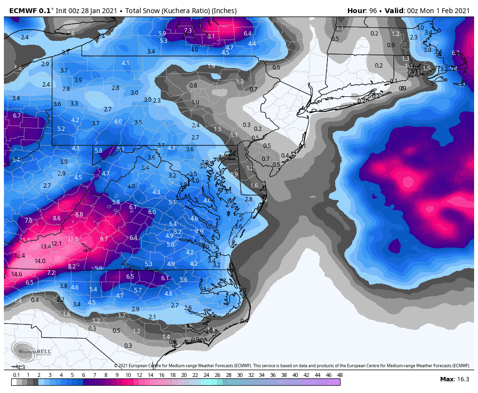


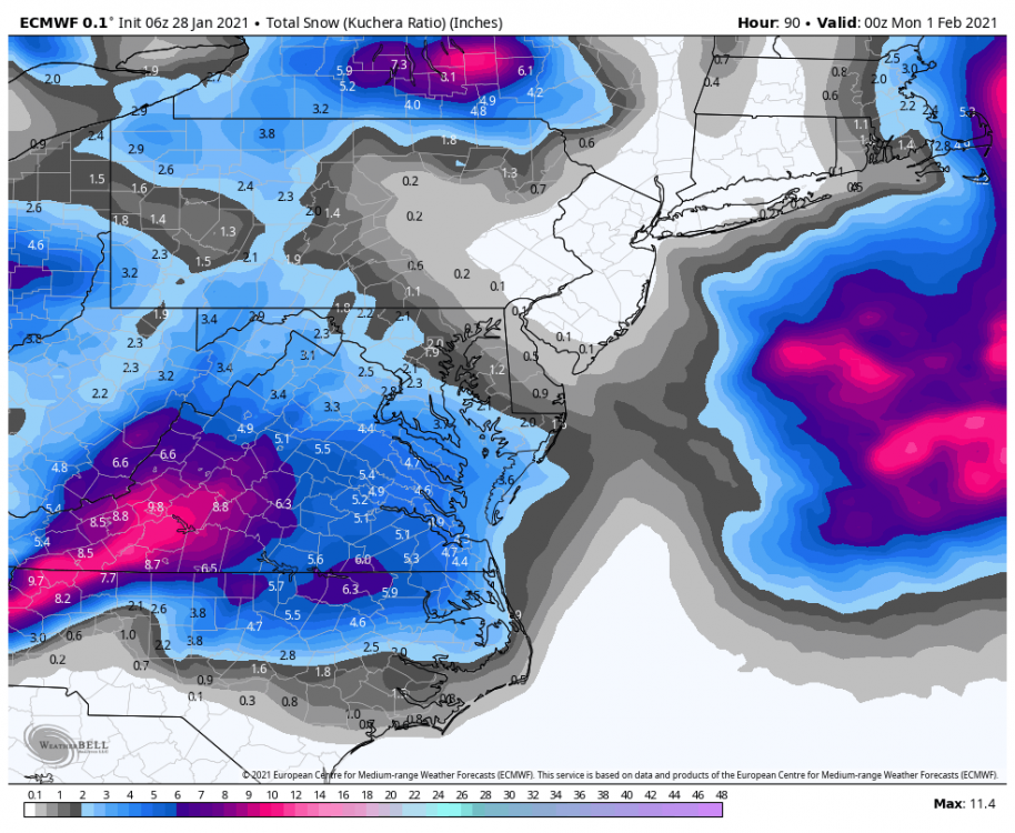
Jan 31 - Feb 2 Storm
in Mid Atlantic
Posted
The higher elevations in Highland County warm up quickly with WAA, often resulting in elevation based ice storms in these setups. I use to live a few miles west of there in Marlinton, WV.