

Paleocene
-
Posts
2,050 -
Joined
-
Last visited
Content Type
Profiles
Blogs
Forums
American Weather
Media Demo
Store
Gallery
Everything posted by Paleocene
-
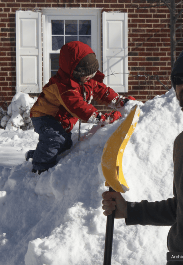
Anyone else sort of in disbelief that we're really tracking this thing? It's been literally 10 years since we've had anything of this magnitude. I am struggling to comprehend the scale of it, lol. Kudos to @NorthArlington101 and @CAPE and many others who were honking about this post jan-15th window, with multiple possible threats. Awkwardly cropped this photo to avoid self doxxing via several means but here's me and my oldest (then 2, now-12 year old) the day after the 2016 storm. He's climbing a mountain I made from unburying one car which was parked on the street. That pile was taller than me and I'm not short. Needless to say, he's hyped up for this potential storm, because he doesn't remember 2016. hope we all get jackpotted
-
Indeed. A fear for northern areas for sure. While the northern crew was gallivanting in oodles of snow in Feb 2014, we lowlanders were getting spittle and dryslot. Different storm, but I like when I see that 32 degree line well SE of me
-
I know it's the ICON, but to illustrate a point, I am amazed with the temps that these models are spitting out. Feels like forever since we've had cold snow in the metropolitan areas. Temps in the mid-teens all the way to Richmond during the storm... though a cutoff on a sharp gradient through a Cape May--->Salisbury access where east flirts with freezing.
-
The totals for metro Atlanta are absolutely bonkers. They gotta pray this is overdone at this point
-
For once I agree - we need only one person doing PBP. the CMC and GFS were a disaster to read/follow this AM.
-
pivotal has them 12z snow, 10:1
-
Anybody else buying up the local supply of ice melt and snow shovels? Today's the day. People gonna lose their minds starting Thurs if this holds
-
Yeah, I know there are lots of caveats with ice maps. But holy smokes.
-
FYI weenie alert for weenies - pivotal weather offers a one week free trial of their geographically zoomed, detailed maps (and access to 06z and 18z euro detail maps). I just signed up. Best week of the year to do that lol, but it does require a credit card. Something I'll be watching over the next 48-72 hours... 850mb and 700mb temperature and wind direction, if and when the low transfers. This image is from the 06z euro, the low is popping off the NC coast. Can the cold press win? If we're gonna get the juice, we may flirt with the heat.
-
I had that thought too. At that point we're calling Gov. Moore to airlift @Jebmanin to shovel us out. Godspeed Jeb Ok that's my banter for the day. Going to lurk mode... Looking forward to today's runs.
-
If this thing holds, Montgomery County school children (like my middle schooler) will be annoyed. They have off Monday for an end of quarter teacher grading day. I think the teachers have to report in though, so they will be happy.
-
the EPS maps that stormyclearweather posted suggest a north tick of precip IMO (from 12z - 18z)
-
Weren't we complaining about euro overdoing cold at range (D6+) earlier this winter? Apologies if I made that up. Not trying to deb, but I thought I remembered discussion of that.
-
Sorry. Too hype. I will respect the rules and keep memes to a minimum. Been waiting for the right moment to use that one and may have been too soon.
-

Appreciating Each Other/Poster Compliments
Paleocene replied to SnowenOutThere's topic in Mid Atlantic
I appreciate everyone on this forum for keeping things interesting all year round. Even when I'm not actively posting, I'm reading. I lurked for years before an account. This is a positive place! I do have one exception. There's that one guy that says emoji reactions are bad and good working class people don't use them. Or something hilarious like that. I'm going to keep karma farming memes in the LR to see if I can get a rise out of them via high numbers of emoji reactions -
at this range we should do a PBP of the GEFS to see if that baja upper low gets stuck. it doens't on the ai
-
Decent afternoon snow TV in Silver Spring, sticking to roofs and grills and such. Even a bit on the grass. Trace?
-
Pretty good day. Hoping for a good HH
-
Thanks. I was in Gettysburg at the time and I have little to no memory of that (college days). One inch fits me not remembering. But then we got annihilated in the twin HECS/MECS
-
You have a snow map for that? What was the northern cutoff
-
Good will you stop posting
-
Those are rookie numbers. We need twenty members with 30" or more for goonfest 2026
-
Maybe I'm off base here but I think our biggest indicator is whether or not Bob Chill is posting. He comes when there are legit threats inside 120 hours (or maybe even shorter, 72). Unsurprisingly he hasn't been here the last last 3-4 weeks since the good December pattern ended. If and when he reappears, we're in business.
-
Divorce happens. Fortunately you still love your kids. That's what matters. Speaking from experience. Back to snow talk
-
@ravensrule


