EastKnox
-
Posts
161 -
Joined
-
Last visited
Content Type
Profiles
Blogs
Forums
American Weather
Media Demo
Store
Gallery
Everything posted by EastKnox
-
December 8-10 Storm Discussion
EastKnox replied to Holston_River_Rambler's topic in Tennessee Valley
6z Euro.thumb.png.065a8815b17e4364392544376d56f6ff.png)
-
December 8-10 Storm Discussion
EastKnox replied to Holston_River_Rambler's topic in Tennessee Valley
I wonder how much of that is ZR? -
December 8-10 Storm Discussion
EastKnox replied to Holston_River_Rambler's topic in Tennessee Valley
Wider look through 162. Sent from my Moto G (5) Plus using Tapatalk -
December 8-10 Storm Discussion
EastKnox replied to Holston_River_Rambler's topic in Tennessee Valley
It was pretty much done at 114. I'll check again though. Sent from my Moto G (5) Plus using Tapatalk -
December 8-10 Storm Discussion
EastKnox replied to Holston_River_Rambler's topic in Tennessee Valley
Hth Sent from my Moto G (5) Plus using Tapatalk -
December 8-10 Storm Discussion
EastKnox replied to Holston_River_Rambler's topic in Tennessee Valley
looking good for NE TN at 126 -
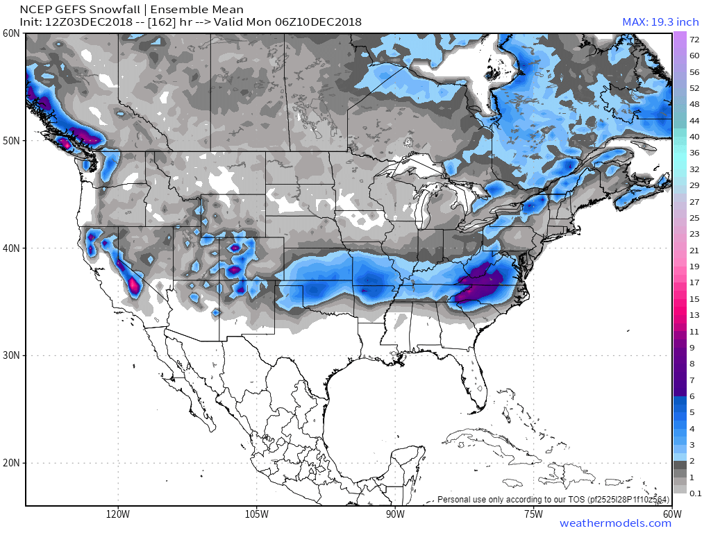
December 2018 Pattern And Forecast Discussion
EastKnox replied to AMZ8990's topic in Tennessee Valley
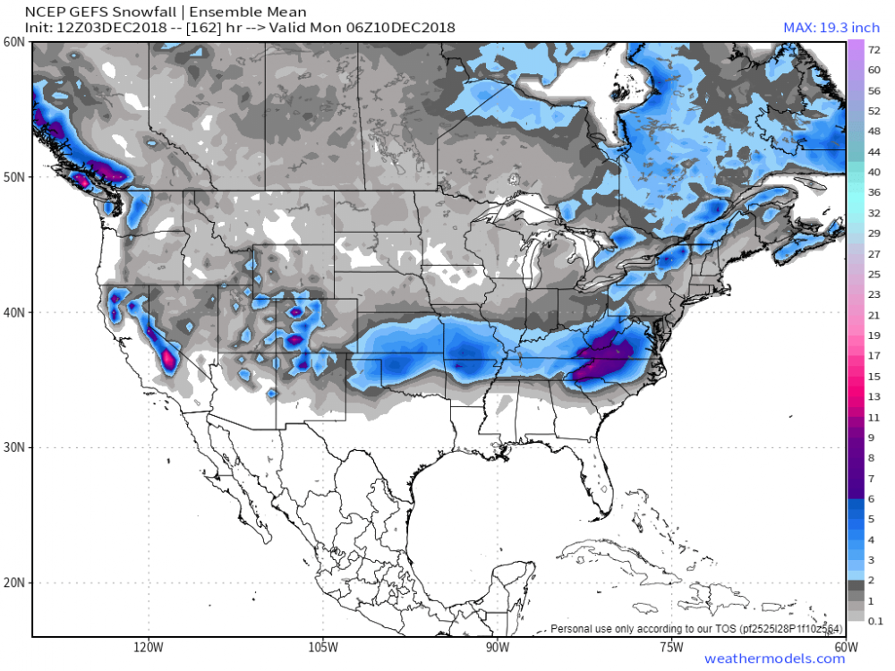
Here are a couple of GEFS images.
-
December 2018 Pattern And Forecast Discussion
EastKnox replied to AMZ8990's topic in Tennessee Valley
Watching the Euro like I'm watching a sports event. Haha. Looks like the 500mb is coming in a little deeper this run and closing off @144. But it also looks like the HP is sliding east. -
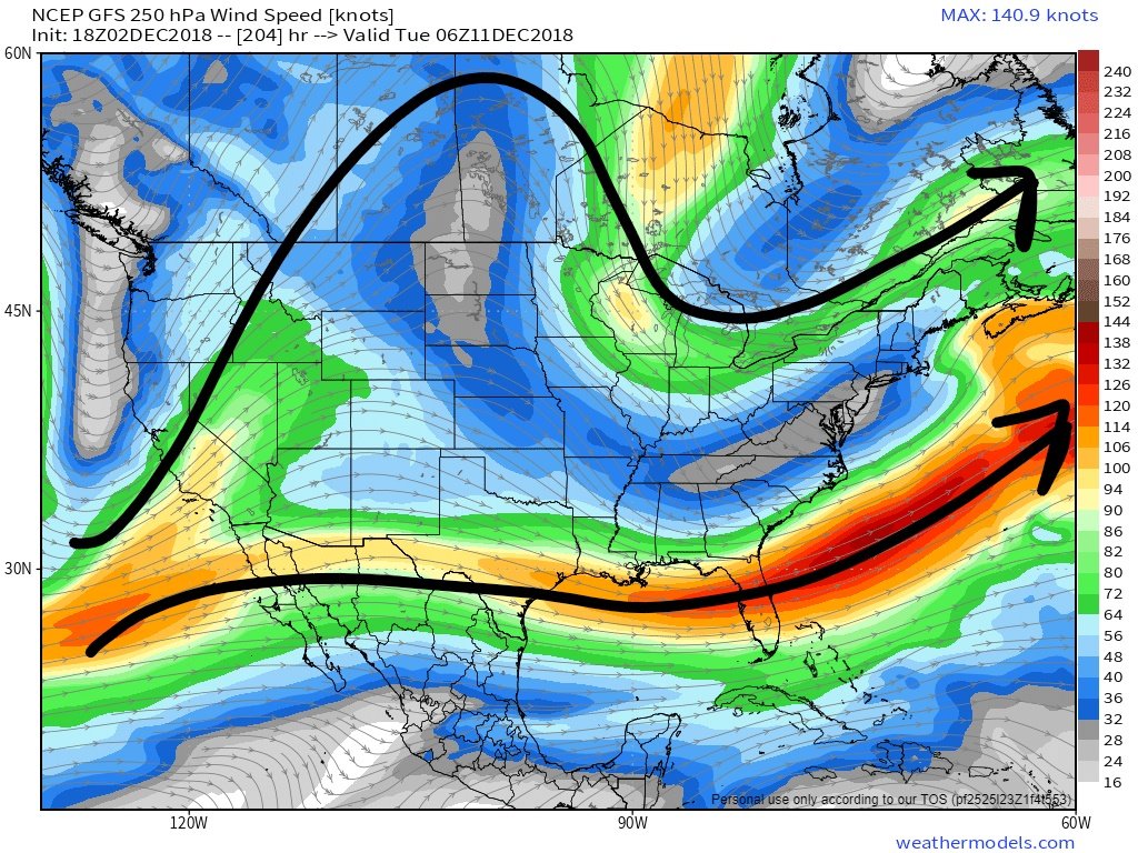
I have started this thread in order to have a place to ask questions about weather phenomena and features we see in models. In particular, I'll see some discussion happening about an upcoming weather event, but may not understand all of what I'm reading. I don't want to muck up the main discussion with general questions so I thought that a separate thread could be helpful for us with less knowledge. Of course, this isn't an atmospheric sciences course condensed into a forum thread, but maybe a few tidbits of info will be shared that we can benefit from. I'll start with one that relates to our current situation. I hear a lot of about split flow of the polar and subtropical jets. What is the best way to identify the split flow? Have I identified it correctly in the 250 mb winds chart below, or would you look elsewhere? (500 mb) and do you look for certain heights (like 540 dm in the 500mb chart) to identify the polar jet?

-
A question to the regular posters and those with more weather knowledge than me...which is practically everyone. Would it be in poor taste to start a sort of "education" thread where one could ask for explanations of certain weather phenomena? Not expecting to replace study and research, but sometimes some things are posted that are obviously over my head and I do my best to scour the internet for explanations. This could be a topic to allow some questions and maybe even a place to post good articles/webpages as we run across them. Thoughts?
-
I'll agree there. We need better data at longer and longer lead times (for the more populous areas) to make the best decisions.
-
No, not saying this was a miss, I'm referring to the situation that causes people to question evacuating in the future. I'm just asking folks to acknowledge that needless evacuations end up hurting too. They cause distrust in those making the evacuation decision and may ultimately save lives in this storm and cost them in another.
-
This is true, but we can't stick our heads in the sand and ignore the flip side - why do people let there guard down? Is it because they evacuated the last storm or two or three and the forecasts were wrong? Do they get desensitized to the hype and then swing too far the other direction? When there is a mandatory evacuation, people lose time at work and then incur the burden of the cost of the evacuation. Most families can't afford it, but make it happen because the government says so. When the storm is over and it wasn't a near miss, but a huge miss, people second guess the next time.
-
Major Hurricane Florence: STORM MODE THREAD
EastKnox replied to stormtracker's topic in Tropical Headquarters
Looks like a little southerly shear at the moment.
-
Looks like he actually joined in 2010, so maybe he does read more and post less?? He may be bitter due to the missed flight and all, but it shouldn't erase the validity of one of his points...desensitizing of the public after many "cry wolf" situations. A coworker of mine who telecommutes from the area evacuated as requested on Tuesday at 12 noon. After seeing some irresponsible social media posts AND official media dubbing this the "storm of a lifetime," they decided to move even farther inland. I urged them to follow the NHC and their recommendations rather than watch the sensational news stories. And from the fact that a normal 4 hour trip took them 10 hours, I'm guessing many others did the same. If they go back home next week after losing time from work and spending money on a one week hotel stay only to find nothing happened, they'll be more hesitant to act the next time. I have family living in Beaufort that began packing as soon as the governor ordered their evacuation. They got on the road early to beat the traffic only to find out that the evacuation was cancelled the next morning. They then had to immediately turn around to get back to work. I wonder if they'll hesitate the next time an evacuation order is issued. Most of us posting on this forum understand the difficulties in forecasting this stuff and know that when "storm of a lifetime" was thrown around on Tuesday, that it could very well be that or not. The general public is too trusting of the media who frequently leave out pertinent info so that the viewer will draw the most sensational conclusion. As the population of these coastlines continues to increase, it makes the decisions even harder for authorities. Our current technology doesn't allow us to pinpoint with confidence until about 24-36 hours out, but with the population increasing, that isn't enough time to get everyone out of harm's way. We're between a rock and a hard place and the sensationalizing media rarely helps.
-
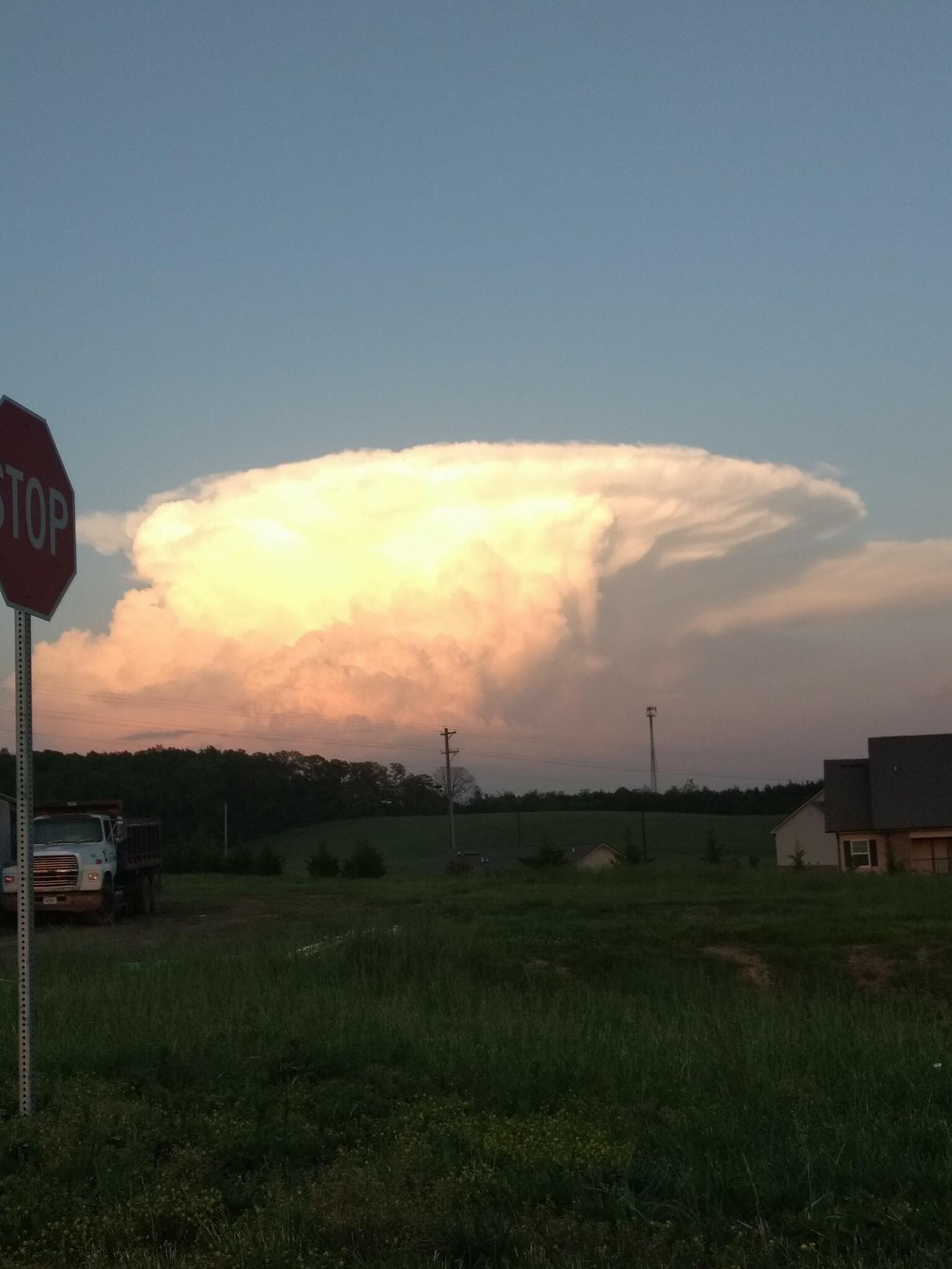
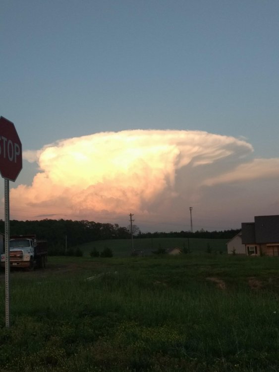
Another pic of the storm in Greene County yesterday.
- 225 replies
-
- 5
-

-

-
- mountain snow
- thunderstorms
- (and 5 more)
-
I don't know if the attached video will be viewable, but current radar is interesting to me- west to east motion on the plateau with south to north motion in the Apps. Screen Record 04 (Converted).mov
- 225 replies
-
- 2
-
-
- mountain snow
- thunderstorms
- (and 5 more)
-
12z GFS indicating dry air at 700mb leading up to and at 2 pm on Monday. With the sun being more than halfway through partial eclipse, maybe this will suppress the Cu like Jeff indicated. Dew points at the surface are also showing low to mid 60's. I noticed that small windfield vortex in W. Tennessee. Is that what's pulling in the dry air from the north?
-
Thanks Jeff...I really enjoy your write ups. I'm going to be about 5 miles east of the plateau and on Watts Bar Lake north of Spring City. It seems that I'm in a favorable location. Hopefully it pans out. I'm going to watch those model updates and hope for low dew points at the surface and at 700mb.
-
We need an exact repeat of this weekend's weather on the weekend prior to the eclipse!
-
That was originally my plan as well, but I feared that I might find myself in a traffic jam trying to get to one of those spots, so I opted for a location that I could anchor down over the weekend and be waiting on Monday.
-
I'm borrowing my in-laws' camper and setting up on Watt's Bar Lake near Spring City on Friday the 18th. I'm hoping for good weather, but will move from "home base" on the 21st if there is a considerable chance of cloudiness. Hoping the next weeklies gives us some preliminary ideas.
-
I'm hoping to make my way up the Cherohala Skyway to find a spot for viewing. I definitely need to grab a solar filter for my scope before then.
.png.b814acc8af6dcb93cdb4fd3cdeb55112.png)