Newman
-
Posts
2,469 -
Joined
-
Last visited
Content Type
Profiles
Blogs
Forums
American Weather
Media Demo
Store
Gallery
Everything posted by Newman
-

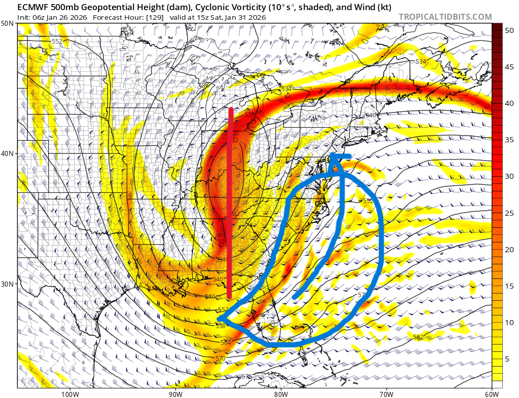
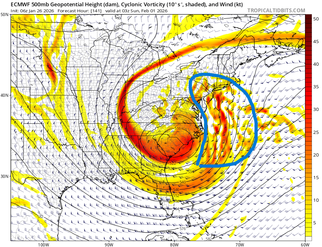
E PA/NJ/DE Winter 2025-26 Obs/Discussion
Newman replied to LVblizzard's topic in Philadelphia Region
Top two pictures are from the 6z Euro from YESTERDAY (1/26) that showed what would've been a top 5 NESIS event. Bottom pictures are from the most recent 18z GFS. From a broader view, you'd think the recent GFS would result in a major snowstorm with a closed off 500mb low about to roll under us. In fact, the confluent vorticity ribbon over northern New England isn't all too different, perhaps a bit further south on the GFS. However, the problem comes down to 6-12 hours of timing. The GFS is 1. 6-12 hours slower in evolution and 2. Just a bit too positively tilted (and slower). What that does is allow the PVA/southern stream energy to escape way out east of the trough before it gets pulled back into New England. Have you seen the GFS seemingly having "convective feedback" issues with multiple lows east of the center? Well, that is why. It doesn't know where the low center should be. The 6z Euro from yesterday though was faster, tilted neutral to negative 6-12 hours sooner, and that phase scooped up that southern stream shortwave/PVA and straight into the Jersey shore. GFS, with the PVA offshore because of a later phase and later tilt neutral/negative: Euro, which had better timing, tilt, etc: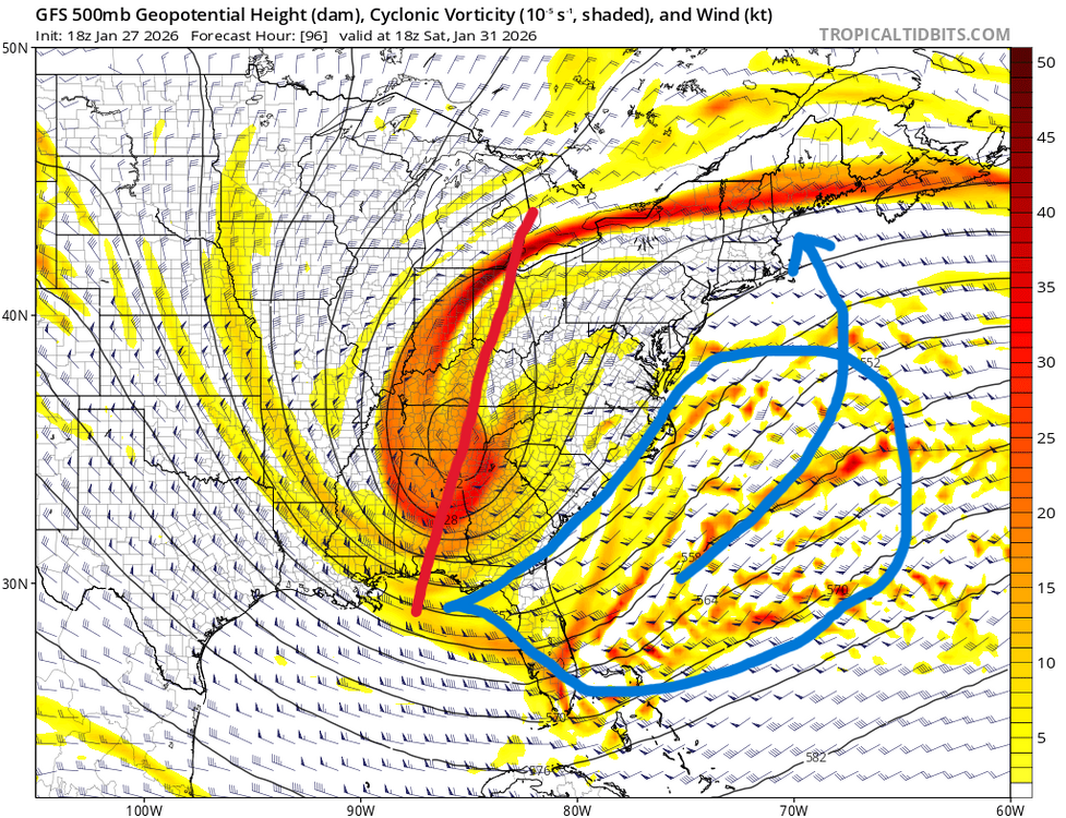


-
E PA/NJ/DE Winter 2025-26 Obs/Discussion
Newman replied to LVblizzard's topic in Philadelphia Region
GEFS looking better at hour 78. More separation of our TPV and better ridging between the two systems already. Not surprised though as the GEFS usually follow the OP. The western ridge also got better.
-
E PA/NJ/DE Winter 2025-26 Obs/Discussion
Newman replied to LVblizzard's topic in Philadelphia Region
GFS... Lol. It's gonna hold or even be better here. -
E PA/NJ/DE Winter 2025-26 Obs/Discussion
Newman replied to LVblizzard's topic in Philadelphia Region
Let's hope 12z was rock bottom with this threat. 18z ICON ensembles much better and the mean sends 0.5" QPF well into southern PA. Yes this is not meant to be taken that seriously, but hey it's a good start to 18z
-
E PA/NJ/DE Winter 2025-26 Obs/Discussion
Newman replied to LVblizzard's topic in Philadelphia Region
A blend of the 12z Allen Iversons (AIs) would put I-95 on the western fringe. -
E PA/NJ/DE Winter 2025-26 Obs/Discussion
Newman replied to LVblizzard's topic in Philadelphia Region
Ridge out west is a bit more amplified on the GFS, better wave separation between our 50/50 and NS shortwave cutting off, and the decaying NAO block is a bit more stout on the GFS forcing the wave more meridional -> pinches off sooner. You're right though, things don't look too dissimilar broadly but it's such a nuanced setup. Looking ahead, you want to see the GFS continue these trends and/or hold them. And need the Euro to adopt greater wave separation with our stretched out TPV. We want subtle ridging to build into New England where the Euro right now has the vorticity ribbon draped and keeping heights too low. -
E PA/NJ/DE Winter 2025-26 Obs/Discussion
Newman replied to LVblizzard's topic in Philadelphia Region
Top 3 CIPS analogs this afternoon based on the 12z GFS: 1. Jan 2016 2. BDB 2010 3. Jan 1996 There's my weenie contribution for the day, because yes we have time to draw this back NW but the Euro remaining put doesn't inspire confidence. -
E PA/NJ/DE Winter 2025-26 Obs/Discussion
Newman replied to LVblizzard's topic in Philadelphia Region
Verbatim, the storm occludes too far SE for the majority of SE PA. Again, if we get similar evolution but the shortwave doesn't dig as far south, this occludes right at our latitude and we get those massive totals that are currently depicted over Richmond. Need to see the Euro at least trend towards this, -
E PA/NJ/DE Winter 2025-26 Obs/Discussion
Newman replied to LVblizzard's topic in Philadelphia Region
12z GFS looking remarkably improved, gonna be a big hit for at least eastern folks -
E PA/NJ/DE Winter 2025-26 Obs/Discussion
Newman replied to LVblizzard's topic in Philadelphia Region
I wonder if we can sacrifice a super wound up, phased, negative tilted system with just having it dig less south and close off closer to our latitude. At least then you get some ULL snows. Certainly not giving up on this one yet, the larger setup is volatile to small changes -
E PA/NJ/DE Winter 2025-26 Obs/Discussion
Newman replied to LVblizzard's topic in Philadelphia Region
GFS is so close now. Our southern energy that phases with our closed off NS energy races out ahead just too much and doesn't get scooped up, so all of that PVA is too far OTS. That's what made the 6z Euro so special, the timing was nearly ideal with the trough turning negative and scooping up that southern energy/PVA and directing it straight into the Jersey shore. Let's see what the other models do here tonight. -
E PA/NJ/DE Winter 2025-26 Obs/Discussion
Newman replied to LVblizzard's topic in Philadelphia Region
The storm almost becomes warm core secluded with intense CAA/N winds on the western side of the system. Plus when it becomes vertically stacked, it occludes and you lose that mid-level WAA. Such an intense system would have an intense thermal contrast and there'd be a CCB/fronto band on the western side that helps to cool the column as well. -
E PA/NJ/DE Winter 2025-26 Obs/Discussion
Newman replied to LVblizzard's topic in Philadelphia Region
I like where we're at. If we see things continue to trend worse over the next 2-3 days, well then yeah this might just go OTS. Let's just hold it here and I'm fairly confident we can back this NW with favorable ticks with the ridge out west and the TPV split. There is absolutely no reason to be cliff jumping, I mean a lot of y'all just got double digit snows yesterday. We just saw very favorable shifts on the GFS suite, Canadian suite, and ICON. Lean on the ensembles for the next 2-3 days. -
E PA/NJ/DE Winter 2025-26 Obs/Discussion
Newman replied to LVblizzard's topic in Philadelphia Region
GFS is exactly where you want it. CMC is just incredible. A 955mb bomb on the benchmark. Sure verbatim its a tad east for some, but look at the trends... this one isn't done correcting yet. -
E PA/NJ/DE Winter 2025-26 Obs/Discussion
Newman replied to LVblizzard's topic in Philadelphia Region
Just for fun before we turn to the 12z runs, end of the Euro had 16-18" of snow fall in 6 hours across Central Jersey. And the storm was just getting started. -
E PA/NJ/DE Winter 2025-26 Obs/Discussion
Newman replied to LVblizzard's topic in Philadelphia Region
I totally agree, verbatim we're looking at HECS outputs from the Euro. I'm not biting yet though, will wait until Thursday 0z for full confidence, and even then there will be shifts in directions that screw New England, or screw the Mid-Atlantic, or screw somebody. I do think a super tucked solution will favor Central PA more where they get a CCB and SE PA might dry slot. But then again, it depends on the exact passage of the 700 and 850mb lows. Nitpicking details though at this stage, we'll worry about dry slots once we reel this in synoptically with confidence -
E PA/NJ/DE Winter 2025-26 Obs/Discussion
Newman replied to LVblizzard's topic in Philadelphia Region
I scanned my KU book haha, here is Jan 1966. Notice how there was an elongated PV stretched under a decaying NAO block. The western side of it separated and then amplified under the block, while the eastern side acted as the 50/50. And then the storm cut off and vertically stacked. The difference between this and the 6z Euro? The Euro has the evolution just a bit further south and east
-
E PA/NJ/DE Winter 2025-26 Obs/Discussion
Newman replied to LVblizzard's topic in Philadelphia Region
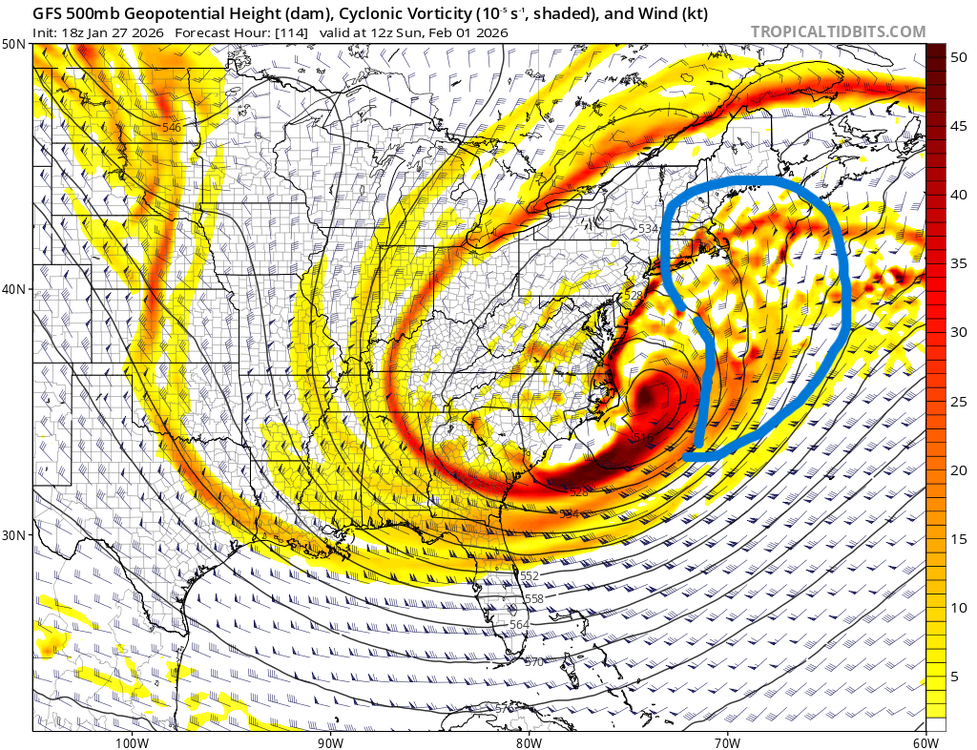
I don't know if Jan 2000 is the best analog verbatim, at least at the upper levels. That one had a southern stream shortwave that got captured by the polar jet and then swung northward up the east coast. https://www.raymondcmartinjr.com/weather/2000/25-Jan-00-500MillibarMaps.html At the surface and as far as sensible impacts go, definitely similarities. But at the upper levels, the 6z Euro output is even more anomalous. January 1966 is actually a pretty dang close analog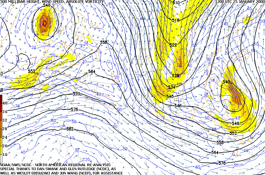
-
E PA/NJ/DE Winter 2025-26 Obs/Discussion
Newman replied to LVblizzard's topic in Philadelphia Region
Wow, just wow. The Euro suite last night and now this morning is a beaut. 24-36 hour storm for many. 970s mb bomb parked right off the Delmarva. CCB just cranks -
E PA/NJ/DE Winter 2025-26 Obs/Discussion
Newman replied to LVblizzard's topic in Philadelphia Region
Just from experience, it feels like an NYC and New England type of storm is brewing but can't rule out we get something crawl up the coast like the 18z Euro -
E PA/NJ/DE Winter 2025-26 Obs/Discussion
Newman replied to LVblizzard's topic in Philadelphia Region
Geez, like a light switch all of the models are showing this one now. No sleep for the weary! -
10" total in Fleetwood. About 8.5" snow and then 1.5" sleet. Now time to see how low we go tomorrow and Tuesday night with clear skies and fresh snowpack. Season total is at 25.2"
-
Up to 9" total sneet Been hella busy down here with our Tornado watch and a few radar confirmed tornadoes
-
Per the fam, about 8.5" in Fleetwood but now mostly pingers with a few flakes mixing in
-
This is the warmest the 12z HRRR gets at KABE. If this is the case, you'll probably mix with sleet, not do a full change over. Under heavy rates you might flip back and forth between all snow, and a snow/sleet mix. So ratios will be more like 6:1 or 7:1 vs a pure sleet 3:1.