

Scarlet Pimpernel
-
Posts
6,790 -
Joined
-
Last visited
Content Type
Profiles
Blogs
Forums
American Weather
Media Demo
Store
Gallery
Posts posted by Scarlet Pimpernel
-
-
5 minutes ago, BristowWx said:
WSWatches or WWAs on Xmas eve....tough to beat that kind of magic
We did have that, for The Storm Which Shall Not Be Named (*ahem* Dec. 2010 *ahem*). Ducking for cover!
Ooops...
 'd by @mappy, sorry about that!!
-
 1
1
-
-
3 minutes ago, MountainGeek said:
A huge chunk of this forum will beat their annual total from last year and we're not even into our prime snow climo period.....I call that a HUGE win regardless of what happens with the rest of this storm. Something GOOD to remember about 2020 at least.....
Very true! Of course, I could piss ice cubes onto sun-scorched blacktop pavement in mid-July and surpass last winter's snow total!! (Not that I've tried that, LOL!!)
And agree, this event is one of the few bright spots of 2020. Nice to have something wintry in December!
-
 1
1
-
-
1 hour ago, Maestrobjwa said:
Happy 250th birthday to THIS dude...the man, the myth, the legend, and one of the greatest and most influential composers of all time, LUDWIG VAN BEETHOVEN!

I am so glad it's Beethoven day (make it a holiday
 )--a perfect remedy for the current snow fail! Listen to some Beethoven today everyone! (Classical WETA 90.9 is playing Beethoven all day today...and I'm lovin' every minute of it!)

Amen!! I've got the entire suite of his symphonies, Cleveland Orchestra recordings with George Szell as conductor. Also another copy of the 9th (my favorite), Cleveland Orchestra with Christoph von Dohnanyi. I was fortunate enough to hear the 9th live two times while in Atlanta in the late '90s, with the Atlanta Symphony. Once was with a guest conductor (can't recall who at the moment), and the other time was with Yoel Levi (their regular conductor/musical director at the time). That included the Atlanta Symphony Chorus, still heavily influenced by the great Robert Shaw.
-
1
-
-
1 minute ago, LeesburgWx said:
I legit laughed out loud at the “Nam would be the new King”
Well...to paraphrase the title of a 1975 movie starring Michael Caine and Sean Connery, maybe that should be "The NAM Who Would Be King"!!

(Actually "The Man Who Would Be King", a very fine movie by the way!!)
-
1
-
-
On a lighter note, all this talk of being "obtuse" makes me think of one of my all-time favorite movies, "Shawshank Redemption"...
-
4
-
-
Just now, ers-wxman1 said:
My apologies. Wrong thread.
No apologies needed...I don't think the particular thread you put that in matters all that much. I knew what you were talking about. What you mentioned could apply to damn near any event around here to be honest, in terms of model hugging, tossing, etc. I'll admit myself to being weenie-ish when it comes to snow (we all are to an extent, aren't we?), but I also have to respect the science and reality of what's being shown, even if it's not favorable.
-
1
-
 1
1
-
-
2 minutes ago, North Balti Zen said:
Dude, they chat about 15-day upper air patterns --- GOOD OR BAD --- in this thread all the time. That is what this thread is for. And everyone understands that it is LONG RANGE and illusory - but if you read through the thread indications of potential periods of blocking or not blocking can be discussed. You are being deliberately obtuse.
If you're referring to @ers-wxman1's comment above, he may have intended that for the other thread about this upcoming event. I don't think he's being "obtuse".
I'd rather have far fewer @Ji-type comments with sarcastic (and whining) posts about how a 240 hour forecast took away his 15" snow or how getting a foot is somehow a fail...and far more @ers-wxman1-type posts that are loaded with useful and informed content, even if a bit jaded at some people's attitudes and occasionally harsh on the reality of marginal setups!
-
2
-
1
-
-
1 minute ago, 40westwx said:
I want you all to be prepared for the greatest succession of model runs in Mid Atlantic snow storm history.. over the next 36 hours we are going to see a slow and steady shift to colder temperatures.. all of you all teetering on the brink will see you 1-3 turn in to 2-4.. then to 6-8 and then.. the ever important 8-14.
This shit is happening
@Jebman, is that you??
-
1
-
3
-
-
13 minutes ago, stormtracker said:
Almost went there, but I'm an admin. Have to set the fucking standard around here for good language and good behavior.
Well, instead of an underline for the "u", you could go for the German umlaut: "Have to set the fücking standard..." Has a nice ring to it when you pronounce the umlaut-u!!
-
Just now, Warm Nose said:
Yeah but ahead of 'wishing really hard' though, so there's still hope!
I think that's the new, modern term for "persistence"!!
-
1 minute ago, H2O said:
Remember that in the list of useful models the UKMET wasn't very high.
Just below Hieroglyphics, I believe?
-
11 minutes ago, Cobalt said:

Can someone smart explain the lp difference here? Seems to be in a more realistic spot given the GEFS support.
Won't claim to be smart (hahaha!). But just eyeballing that, the difference appears to be subtle. Notice at 06Z, there is a western low center right along the Delmarva and another one to the east. The "eastern" one looks stronger (1000 mb), maybe the GFS keyed more on that at that time? At 12Z, the same thing...a "western" and "eastern" center. But in that case, the western center is stronger...in fact quite a bit stronger (992 mb), and the eastern low is farther out and weaker.
-
5 minutes ago, NorthArlington101 said:

Filled out a couple more squares. Might’ve missed an Eskimo Joe “meh.”
Wait...when was there a reference to the DGEX for this event??? Don't recall that offhand...fortunately!!
Oh, and by the way, I think the NAM is just where we want it at this range, it's showing a slight improvement!
-
1
-
-
1 minute ago, WinterWxLuvr said:
Yep that’s what I was thinking.
Of course each one of those stupid shades could be a six inch contour so we could be looking at a range of 0 to 1000”. Who knows. That’s why I love them so much
You get pummeled according to that legend-less map, and there's a hint of the @psuhoffman fringe zone in there too! (All in fun and joking, PSU, but you know that!!).
-
7 minutes ago, Eskimo Joe said:
As you near an event, the OP and ENS will not diverge as much.
1 minute ago, CAPE said:Yeah that's the general idea lol. At this range we can still see some differences, but going forward the op runs are where it's at. Probably around this time tomorrow.
That's kind of what I was thinking. Maybe continue giving ensembles weight up to say, nearly 48 hours before the event (so sometime tomorrow for this event). Then almost exclusively deterministic thereafter. At least that's what I've gotten from what most have said over the past couple of years.
-
Just now, Maestrobjwa said:
Fixed it for ya pops
")
LOL!!! Well, this helps too...beer goggles for snow!

-
4
-
-
Just now, PhineasC said:
The easy rule is: purple is good, whitish is really good, and bluish is incredible.
LOL yeah, I know...typically I look for where the initial lighter purple is and go from there, hahaha! The green, of course stands out most. Thanks for walking across my lawn!!
-
1
-
-
17 minutes ago, MN Transplant said:
Better than 12z
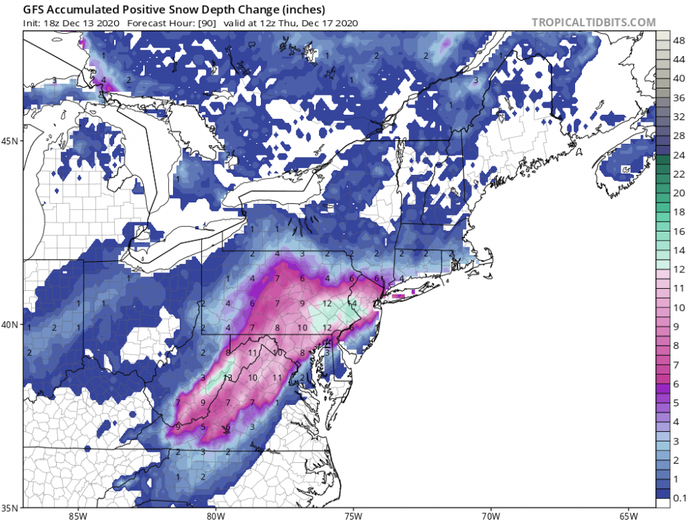
Throwing this out here randomly (not aimed at you, just using this plot as an example!). But damn, I never much liked these all-to-subtle color transitions, especially on the snow maps! My old(er) eyes have a hard time discerning those tight gradient transitions from the light blues to light purples, then darker purples, then pink!! LOL!! Now...get off my lawn you damn whipper-snappers, while I get my magnifying glass out!!

-
1
-
-
1 minute ago, NorthArlington101 said:
GEFS held serve. Beautiful verbatim,
12z:

06z:

Looks quite similar, going by the overall "shape" and coverage. Biggest difference is that the amounts are noticeably bumped up (whatever it's worth, on these maps!)...presumably due to the enhanced CCB at 12Z vs. 06Z?
-
59 minutes ago, snowfan said:
Yoda is a bot programmed to give pbp for every model run of every model.
@yoda might possibly reply: "Mmmmm! Model pbp or model pbp not! There is no bot!"
(ETA: "Mmmmm, poet I am!")
-
37 minutes ago, yoda said:
Really? Does the rain stay mainly on the plain? @MN Transplant bad joke there good sir
"Heavens, what a sound!!"
-
2
-
-
4 minutes ago, WxUSAF said:
I’ve only looked at posts this morning so far, but seems the models runs are all bouncing within a certain range and we pretty much know what that is. I81 crowd probably is shellacked in any scenario. I95 crowd probably mixes in every scenario. Eastern shore down to RIC is mostly rain in every scenario (sorry friends). Everything I see suggest almost all of LWX gets a WSW. I’ll also say that I’ll take my sleet and rain Wednesday evening and say “thank you sir may I have another!?” if it means I get the kind of deform band that is being advertised.
Agree. This is a very good overall summary. And I'll also take this opportunity to thank @MillvilleWx for the amazing discussions (even when on mids...not to be confused with meds!!
) as well as @MN Transplant, @psuhoffman. Thanks for keeping it real and civil, regardless of what each model run shows.
With a little luck where I'm at just on the northwest side of the beltway, it will be more sleety than rain through that time later Wednesday afternoon. I'm intrigued by the after-00Z Wednesday evening into late Wednesday night timeframe as well, if that deform band produces. Nobody around I-95 should be expecting a foot-plus, but a decent warning-level event seems quite possible. Which is far more than many of us have gotten in nearly 2 years.
-
4
-
-
Just now, Scraff said:
King Euro better not rain our snow parade.
Of all the 3 "main" models, the Euro is perhaps the most iffy, so to speak, for the metro areas and southeast. But even with that, it's still been a pretty solid hit or better (depending on location of course)...and not far from the GFS and CMC.
-
1
-
-
Here's how the last couple days of model runs seemed...
--00/12Z GFS: Total beat-down, pummeling, crushed!
--00/12Z CMC: Hold my beer...!
-
2
-


December Medium/Long Range Discussion
in Mid Atlantic
Posted
The JMA 850mb 0C line is *just* a bit outside!